Sveadahl | |
|---|---|
 Sveadahl  Sveadahl | |
| Coordinates: 44°04′27″N 94°44′22″W / 44.07417°N 94.73944°W | |
| Country | United States |
| State | Minnesota |
| County | Watonwan |
| Elevation | 1,073 ft (327 m) |
| Time zone | UTC-6 ( Central (CST)) |
| • Summer ( DST) | UTC-5 (CDT) |
| Area code | 507 |
| GNIS feature ID | 652872 [1] |
Sveadahl is an unincorporated community located in Adrian Township, Watonwan County, Minnesota, United States. [1] The elevation is 1,073 feet. [2]
History
A post office called Sveadahl was established in 1892, and remained in operation until 1907. [3] Sveadahl is a name derived from Swedish meaning "Swedish valley". [4]
References
- ^ a b "Sveadahl". Geographic Names Information System. United States Geological Survey, United States Department of the Interior.
- ^ Minnesota Hometown Locator
- ^ "Watonwan County". Jim Forte Postal History. Retrieved August 14, 2015.
- ^ Upham, Warren (1920). Minnesota Geographic Names: Their Origin and Historic Significance. Minnesota Historical Society. p. 576.
Municipalities and communities of
Watonwan County, Minnesota, United States | ||
|---|---|---|
| Cities | 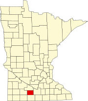 | |
| Townships | ||
|
Unincorporated communities | ||
| Footnotes | ‡This populated place also has portions in an adjacent county or counties | |