This article has multiple issues. Please help
improve it or discuss these issues on the
talk page. (
Learn how and when to remove these template messages)
|
| Super Besse | |
|---|---|
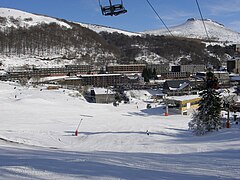
 The station and the foot of the ski slopes | |
| Location | Besse-et-Saint-Anastaise |
| Nearest major city | Clermont-Ferrand |
| Coordinates | 45°30′38.52″N 2°51′24.30″E / 45.5107000°N 2.8567500°E |
| Top elevation | 1,800 m (5,900 ft) |
| Base elevation | 1,350 m (4,430 ft) |
| Trails | 27 |
| Lift system | 23 |
| Lift capacity | 24,000 people/hour |
| Website |
www |
Super Besse is a winter sports resort located in Massif Central, France.

Geography
Super Besse located in the commune of Besse-et-Saint-Anastaise (Parc naturel régional des volcans d'Auvergne in the department of Puy-de-Dôme, Auvergne). Situated approximately 50 km from Clermont-Ferrand, it is located at an altitude of 1350 m on the slopes of Puy de Sancy, Puy de la Perdrix and Puy Ferrand.
Climate
| Climate data for Superbesse, 1287m (1981−2010 normals, 1976−2022 extremes) | |||||||||||||
|---|---|---|---|---|---|---|---|---|---|---|---|---|---|
| Month | Jan | Feb | Mar | Apr | May | Jun | Jul | Aug | Sep | Oct | Nov | Dec | Year |
| Record high °C (°F) | 17.0 (62.6) |
19.1 (66.4) |
19.3 (66.7) |
20.9 (69.6) |
25.7 (78.3) |
33.7 (92.7) |
32.0 (89.6) |
30.6 (87.1) |
27.0 (80.6) |
23.6 (74.5) |
20.6 (69.1) |
17.4 (63.3) |
33.7 (92.7) |
| Mean daily maximum °C (°F) | 2.8 (37.0) |
3.0 (37.4) |
5.2 (41.4) |
7.6 (45.7) |
12.1 (53.8) |
15.8 (60.4) |
18.7 (65.7) |
18.3 (64.9) |
14.8 (58.6) |
11.3 (52.3) |
5.9 (42.6) |
3.8 (38.8) |
9.9 (49.9) |
| Daily mean °C (°F) | −0.1 (31.8) |
−0.1 (31.8) |
1.9 (35.4) |
4.1 (39.4) |
8.3 (46.9) |
11.8 (53.2) |
14.4 (57.9) |
14.1 (57.4) |
10.9 (51.6) |
7.8 (46.0) |
3.0 (37.4) |
0.9 (33.6) |
6.4 (43.5) |
| Mean daily minimum °C (°F) | −3.1 (26.4) |
−3.2 (26.2) |
−1.4 (29.5) |
0.6 (33.1) |
4.6 (40.3) |
7.8 (46.0) |
10.0 (50.0) |
10.0 (50.0) |
7.1 (44.8) |
4.4 (39.9) |
0.0 (32.0) |
−1.9 (28.6) |
2.9 (37.2) |
| Record low °C (°F) | −22.0 (−7.6) |
−20.5 (−4.9) |
−15.0 (5.0) |
−10.5 (13.1) |
−7.0 (19.4) |
−1.0 (30.2) |
2.0 (35.6) |
0.5 (32.9) |
−2.5 (27.5) |
−7.0 (19.4) |
−14.0 (6.8) |
−16.6 (2.1) |
−22.0 (−7.6) |
| Average precipitation mm (inches) | 202.7 (7.98) |
197.5 (7.78) |
178.6 (7.03) |
166.7 (6.56) |
164.2 (6.46) |
152.0 (5.98) |
130.6 (5.14) |
124.2 (4.89) |
159.4 (6.28) |
206.4 (8.13) |
219.6 (8.65) |
221.7 (8.73) |
2,123.6 (83.61) |
| Source: Meteociel [1] | |||||||||||||
Facilities

The on piste skiing consists of 43 km distributed on 27 tracks (5 green, 9 blue, 9 red and 4 black) between 1300 m and 1840 m altitude, on the south-eastern slope of Puy de Sancy. It contains 21 ski lifts. It also includes 125 km of cross-country skiing.
The resort includes:
- 1 funitel with 20 places (new in 2008)
- 4 chair-lifts
- 16 ski-lifts.
Tour de France
Super-Besse hosted the first mountain finish of the 2008 Tour de France. The finish was at an altitude of 1289 m, whereas in previous years the finish was at 1350 m.
Tour de France stage finishes
| Year | Stage | Start of stage | Distance (km) | Category of climb | Stage winner | Yellow jersey |
|---|---|---|---|---|---|---|
| 2011 | 8 | Aigurande | 189 | 3 | ||
| 2008 | 6 | Aigurande | 195.5 | 2 | ||
| 1996 | 13 | Le Puy-en-Velay | 177 | 3 | ||
| 1978 | 13 | Figeac | 221.5 | 3 |
Alejandro Valverde is listed as the winner for the 2008 stage as original stage winner Riccardo Riccò was removed from the classification after testing positive for the banned performance enhancer CERA.
Details of climb
Starting from Besse-et-Saint-Anastaise (1040 m), the climb to Super Besse (1325 m) is 7.2 km long. Over this distance, the climb is 285 m (an average of 3.95%). The maximum gradient is 8.4%.
From the valley at Lomprat the total climb is 11 km at 4.7%.
References
- ^ "Normales et records pour Superbesse (63)". Meteociel. Retrieved April 17, 2024.
