(Redirected from
Strabane (CDR) railway station)
Strabane (CDR) | |
|---|---|
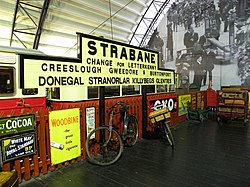
 Station sign in the
Ulster Folk and Transport Museum in
Cultra. | |
| General information | |
| Location | Station Rd. Strabane, County Tyrone Northern Ireland UK |
| Coordinates | 54°49′50″N 7°28′13″W / 54.830478°N 7.470319°W |
| Elevation | 13 ft |
| History | |
| Original company | Donegal Railway Company |
| Post-grouping | County Donegal Railways Joint Committee |
| Key dates | |
| 16 July 1894 | Station opens |
| 1 January 1960 | Station closes |
Strabane (CDR) railway station was one of two terminals serving Strabane, County Tyrone in Northern Ireland.
The Finn Valley Railway operated an Irish Gauge route to Stranorlar from Strabane (GNI) railway station from 7 September 1863. When this route was converted to 3 ft (914 mm) on 16 July 1894 the Donegal Railway Company built Strabane (CDR) railway station adjacent to the existing Great Northern Railway (Ireland) railway station. The two stations were connected by a footbridge.
The station was also later the terminus for the Strabane and Letterkenny Railway which operated from 1909. The station closed on 1 January 1960. [1]
The site is now occupied by an Asda supermarket car park.
Routes
| Preceding station | Disused railways | Following station | ||
|---|---|---|---|---|
| Terminus |
Donegal Railway Company Strabane to Stranorlar 1894-1960 |
Clady | ||
| Ballymagorry |
Donegal Railway Company Londonderry to Strabane 1900-1955 |
Terminus | ||
| Terminus |
Strabane and Letterkenny Railway Strabane to Letterkenny 1909-1960 |
Lifford Halt |
References
- ^ "Strabane (CDJ) station" (PDF). Railscot - Irish Railways. Retrieved 24 May 2008.
Categories:
- Disused railway stations in County Tyrone
- Railway stations opened in 1894
- 1894 establishments in Ireland
- 1960 disestablishments in Northern Ireland
- Railway stations in Northern Ireland opened in the 1890s
- Railway stations in the Republic of Ireland opened in the 1890s
- Railway stations in Northern Ireland closed in 1960
- Railway stations in the Republic of Ireland closed in 1960
- Northern Ireland railway station stubs
- Irish railway station stubs