Stoney Fork, Kentucky | |
|---|---|
 Stoney Fork, Kentucky | |
| Coordinates: 36°49′56″N 83°32′05″W / 36.83222°N 83.53472°W | |
| Country | United States |
| State | Kentucky |
| County | Bell |
| Elevation | 1,112 ft (339 m) |
| Time zone | UTC-5 ( Eastern (EST)) |
| • Summer ( DST) | UTC-4 (EDT) |
| ZIP code | 40988 |
| Area code | 606 |
| GNIS feature ID | 504491 [1] |
Stoney Fork is an unincorporated community in Bell County, Kentucky, United States. Stoney Fork is located on Kentucky Route 221 10.1 miles (16.3 km) east-northeast of Pineville. [2] Stoney Fork has a post office with ZIP code 40988, which opened on November 20, 1946. [3] [4]
References
- ^ "Stoney Fork". Geographic Names Information System. United States Geological Survey, United States Department of the Interior.
- ^ State Primary Road System: Bell County (PDF) (Map). Kentucky Transportation Cabinet. 2012. Retrieved February 23, 2013.
- ^ United States Postal Service (2012). "USPS - Look Up a ZIP Code". Retrieved February 15, 2012.
- ^ "Postmaster Finder - Post Offices by ZIP Code". United States Postal Service. Retrieved February 23, 2013.
Municipalities and communities of
Bell County, Kentucky, United States | ||
|---|---|---|
| Cities | 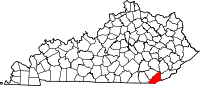 | |
| CDP | ||
|
Other unincorporated communities |
| |
|
post offices (and the creeks they are on) |
| |
| Ghost towns | ||
| Footnotes | ‡This populated place also has portions in an adjacent county or counties | |
|
| This Bell County, Kentucky state location article is a stub. You can help Wikipedia by expanding it. |