Springtown, New Jersey | |
|---|---|
 The
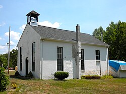
Bethel African Methodist Episcopal Church in Springtown is listed on the
National Register of Historic Places | |
| Coordinates: 39°24′51″N 75°19′54″W / 39.41417°N 75.33167°W | |
| Country | |
| State | |
| County | Cumberland |
| Township | Greenwich |
| Elevation | 11 m (36 ft) |
| Time zone | UTC−05:00 ( Eastern (EST)) |
| • Summer ( DST) | UTC−04:00 (EDT) |
| GNIS feature ID | 880822 [1] |
Springtown is an unincorporated community in Greenwich Township, in Cumberland County, in the U.S. state of New Jersey. [1] [2] [3]
Springtown is located approximately 6 mi (9.7 km) west of Bridgeton, New Jersey.
Springtown, and the nearby community of Othello, were both founded shortly after the American Revolution by African Americans. [4]
History
Legislation enacted in 1786 enabled Quakers living in Greenwich Township to sell tracts of land to " free negros". Many African Americans soon located to Springtown, and the community became a center of abolitionist activity. Harriet Tubman frequented Springtown from 1849 to 1853, and the settlement was an important station on the Underground Railroad, with five of Cumberland County's seven "station masters" living there. [5] [6]
The Bethel African Methodist Episcopal Church in Springtown offered lodging to fugitive slaves traveling north after leaving Delaware and Maryland's Eastern Shore. [5]
References
- ^ a b c U.S. Geological Survey Geographic Names Information System: Springtown
- ^ Locality Search, State of New Jersey. Accessed June 9, 2016.
- ^ Gannett, Henry (January 28, 1895). "A Geographic Dictionary of New Jersey". U.S. Government Printing Office – via Google Books.
- ^ New Jersey, A Guide to Its Present and Past. Best Books. 1939. p. 643. ISBN 9781623760298.
- ^ a b "Aboard the Underground Railroad: Bethel AME Church". National Park Service. Retrieved October 20, 2016.
- ^ Harrison, Charles (2013). Cumberland County, New Jersey: 265 Years of History. History Press. p. 74. ISBN 9781609497767.


