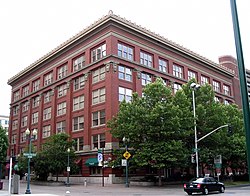
Spokane City Hall Building | |
 The building in 2005 | |
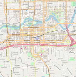
| Location | North 221 Wall Street and West 711 Spokane Falls Blvd., Spokane, Washington |
|---|---|
| Coordinates | 47°39′35″N 117°25′18″W / 47.65972°N 117.42167°W |
| Area | less than one acre |
| Built | 1912 |
| Architect | Julius Zittel |
| Architectural style | Chicago, Commercial Style |
| NRHP reference No. | 85000350 [1] |
| Added to NRHP | February 21, 1985 |
The Spokane City Hall Building is a historic building in Spokane, Washington. It was designed by German-born architect Julius Zittel, and built in 1912. [2] It was used as Spokane's city hall until 1982, when it was replaced with new offices in a former Montgomery Ward department store. [2] [3] The old city hall was listed on the National Register of Historic Places on February 21, 1985. [1]
References
- ^ a b "National Register Information System". National Register of Historic Places. National Park Service. November 2, 2013.
- ^ a b John P. Morrow (November 28, 1983). "National Register of Historic Places Inventory/Nomination: Spokane City Hall Building". National Park Service. Retrieved December 29, 2019. With accompanying pictures
-
^ Craig, John (February 17, 1982).
"City's Mr. Goodwrench: Architect scurries to debug quirks in new City Hall".
Spokane Chronicle. p. 5. Retrieved December 29, 2019 – via
Newspapers.com.

