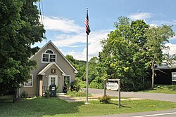
Spencertown, New York | |
|---|---|
 | |
| Coordinates: 42°19′24″N 73°32′45″W / 42.32333°N 73.54583°W | |
| Country | United States |
| State | New York |
| County | Columbia |
| Town | Austerlitz |
| Elevation | 686 ft (209 m) |
| Time zone | UTC-5 ( Eastern (EST)) |
| • Summer ( DST) | UTC-4 (EDT) |
| ZIP code | 12165 |
| Area code | 518 |
| GNIS feature ID | 965990 [1] |
Spencertown is a hamlet in the town of Austerlitz, Columbia County, New York, United States. [1] Its ZIP code is 12165. [2]
The Daniel and Clarissa Baldwin House, Pratt Homestead, Spencertown Academy, and St. Peter's Presbyterian Church and Spencertown Cemetery are listed on the National Register of Historic Places. [3] [4]
Gallery
Notes
- ^ a b "Spencertown, New York". Geographic Names Information System. United States Geological Survey, United States Department of the Interior.
- ^ United States Postal Service (2015). "USPS - Look Up a ZIP Code". Retrieved December 28, 2015.
- ^ "National Register Information System". National Register of Historic Places. National Park Service. July 9, 2010.
- ^ "National Register of Historic Places Listings". Weekly List of Actions Taken on Properties: 6/25/12 through 6/29/12. National Park Service. July 6, 2012.


