South Rhodes
Νότια Ρόδος | |
|---|---|
 South Rhodes Location within Rhodes  | |
| Coordinates: 36°01′N 27°55′E / 36.017°N 27.917°E | |
| Country | Greece |
| Administrative region | South Aegean |
| Regional unit | Rhodes |
| Municipality | Rhodes |
| Area | |
| • Municipal unit | 379.1 km2 (146.4 sq mi) |
| Population (2021)
[1] | |
| • Municipal unit | 3,704 |
| • Municipal unit density | 9.8/km2 (25/sq mi) |
| Time zone | UTC+2 ( EET) |
| • Summer ( DST) | UTC+3 ( EEST) |
| Website | Official website |
South Rhodes ( Greek: Νότια Ρόδος - Nótia Ródos) is a former municipality on the island of Rhodes, in the Dodecanese, Greece. Since the 2011 local government reform it is part of the municipality Rhodes, of which it is a municipal unit. [2]
Geography
The municipal unit comprises the southernmost portion of the island, and is a result of a union of ten former communities:
| Community | Population (2021) [1] | Area (km²) [3] | Localities (main locality shown in italics) |
|---|---|---|---|
|
Apolakkia (Απολακκιά) |
409
|
29.1
|
Apolakkia |
|
Arnitha (Αρνίθα) |
124
|
22.0
|
Arnitha |
|
Asklipieio (Ασκληπιείο) |
765
|
46.6
|
Asklipieio Kiotari |
|
Gennadi (Γεννάδι) |
1,224
|
33.5
|
Gennadi |
|
Istrios (Ίστριος) |
160
|
18.4
|
Istrios |
|
Kattavia (Κατταβιά) |
323
|
97.4
|
Kattavia Agios Pavlos Machairia Plimmyri Prasonisi |
|
Lachania (Λαχανιά) |
139
|
25.4
|
Lachania |
|
Mesanagros (Μεσαναγρός) |
96
|
51.8
|
Mesanagros |
|
Profilia (Προφίλια) |
131
|
15.9
|
Profilia |
|
Vati (Βάτι) |
333
|
39.1
|
Vati |
At the 2021 census, the population was 3,704. It has a land area of 379.050 km², [3] covering about 27 percent of the island's area. The seat of the municipality was in Gennádi.
Gallery
-
 A square in Kattavia
 -
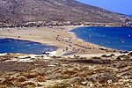 Prasonisi beach
 -
 Church of the Dormition in Asklipieio
 -


References
- ^ a b "Αποτελέσματα Απογραφής Πληθυσμού - Κατοικιών 2021, Μόνιμος Πληθυσμός κατά οικισμό" [Results of the 2021 Population - Housing Census, Permanent population by settlement] (in Greek). Hellenic Statistical Authority. 29 March 2024.
- ^ "ΦΕΚ B 1292/2010, Kallikratis reform municipalities" (in Greek). Government Gazette.
- ^ a b "Population & housing census 2001 (incl. area and average elevation)" (PDF) (in Greek). National Statistical Service of Greece.
External links
Wikimedia Commons has media related to
South Rhodes.
- (in English and Greek) South Rhodes official website
- Logo of South Rodes (dewiki)