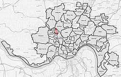
South Cumminsville | |
|---|---|
 | |
| Country | United States |
| State | Ohio |
| City | Cincinnati |
| Population (2020) | |
| • Total | 702 |
| Time zone | UTC-5 ( EST) |
| • Summer ( DST) | UTC-4 (EDT) |
South Cumminsville is one of the 52 neighborhoods of Cincinnati, Ohio. The population was 702 at the 2020 census. [1]
History
This section needs additional citations for
verification. (December 2023) |
South Cumminsville was originally the southern portion of a larger settlement known as Cumminsville. Cumminsville was incorporated in 1865 and annexed into Cincinnati eight years later. In the early 1900s, growth attracted many German Catholics. Cumminsville also attracted a number of African-Americans, who moved to the area of Follett and Dreman avenues. This sub-neighborhood became known as South Cumminsville, according to history books. Boosted by the opening of the Millvale apartments in the 1950s, South Cumminsville evolved into a predominantly African-American community. Many of the newcomers in the northern portions of Cumminsville became to identify themselves with Northside, while South Cumminsville retained its identity.
There was a series of unsolved murders in Cumminsville in the early 1900s. From 1904-1910, five women were killed within a mile of the Spring Grove and Winton Road corner in Cumminsville, earning the neighborhood the nickname "the murder zone" and sparking fear that Cincinnati was experiencing its first serial killer. [2]
Geography
South Cumminsville is bordered by Northside, Camp Washington, Millvale, and Fay Apartments.[ citation needed]
Demographics
| Year | Pop. | ±% | ||
|---|---|---|---|---|
| 1900 | 4,604 | — | ||
| 1910 | 5,360 | +16.4% | ||
| 1920 | 6,100 | +13.8% | ||
| 1930 | 7,136 | +17.0% | ||
| 1940 | 6,641 | −6.9% | ||
| 1950 | 6,464 | −2.7% | ||
| 1960 | 6,866 | +6.2% | ||
| 1970 | 5,237 | −23.7% | ||
| 1980 | 4,908 | −6.3% | ||
| 1990 | 4,367 | −11.0% | ||
| 2000 | 3,914 | −10.4% | ||
| 2010 | 801 | −79.5% | ||
| 2020 | 702 | −12.4% | ||
| ||||
| Numbers before 2010 include both Millvale and South Cumminsville.[ citation needed] | ||||
As of the census of 2020, there were 702 people living in the neighborhood. There were 366 housing units. The racial makeup of the neighborhood was 6.8% White, 83.3% Black or African American, 1.3% Native American, 0.1% Asian, 0.0% Pacific Islander, 2.0% from some other race, and 6.4% from two or more races. 3.4% of the population were Hispanic or Latino of any race. [1]
There were 234 households, out of which 32.1% were families. About 50.4% of all households were made up of individuals. [1]
30.6% of the neighborhood's population were under the age of 18, 50.7% were 18 to 64, and 18.7% were 65 years of age or older. 59.1% of the population were male and 40.9% were female. [1]
According to the U.S. Census American Community Survey, for the period 2016-2020 the estimated median annual income for a household in the neighborhood was $31,288. About 21.3% of family households were living below the poverty line. About 16.8% of adults had a bachelor's degree or higher. [1]
Notable people
- Dave Parker, professional baseball player [3]
References
- ^ a b c d e "South Cumminsville 2020 Statistical Neighborhood Approximation" (PDF). City of Cincinnati. Retrieved 31 December 2023.
- ^ J. T. Townsend
- ^ Schramm, Molly (1 November 2023). "Street in South Cumminsville renamed after Cincinnati native, Reds Hall of Famer Dave Parker". WCPO. Retrieved 7 November 2023.

