This article includes a list of general
references, but it lacks sufficient corresponding
inline citations. (December 2021) |
Songpan County
松潘县 · ཟུང་ཆུ་རྫོང་། · Ssez Sungqu | |
|---|---|
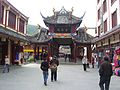
 Terrace in
Huanglong Scenic and Historic Interest Area | |
.png) Location of Songpan County (red) within Ngawa Prefecture (yellow) and Sichuan | |
 Songpan Location of the seat in Sichuan  Songpan Songpan (China) | |
| Coordinates: 32°39′N 103°36′E / 32.650°N 103.600°E | |
| Country | China |
| Province | Sichuan |
| Autonomous prefecture | Ngawa |
| County seat | Jin'an |
| Area | |
| • Total | 8,486 km2 (3,276 sq mi) |
| Elevation | 2,867 m (9,406 ft) |
| Population (2020)
[1] | |
| • Total | 66,937 |
| • Density | 7.9/km2 (20/sq mi) |
| • Major nationalities | Tibetan Han Qiang Hui |
| Time zone | UTC+8 ( China Standard) |
| Postal code | 623300 |
| Area code | 0837 |
| Website |
www |
| Songpan County | |||||||
|---|---|---|---|---|---|---|---|
| Chinese name | |||||||
| Simplified Chinese | 松潘县 | ||||||
| Traditional Chinese | 松潘縣 | ||||||
| |||||||
| Alternative Chinese name | |||||||
| Chinese | 松州 | ||||||
| |||||||
| Tibetan name | |||||||
| Tibetan | ཟུང་ཆུ་རྫོང་། | ||||||
| |||||||
| Qiang name | |||||||
| Qiang | Ssez | ||||||
Songpan County, former Songzhou, is a county of northwestern Sichuan province, China, and is one of the 13 counties administered by the Ngawa Tibetan and Qiang Autonomous Prefecture. It has an area of 8,486 square kilometres (3,276 sq mi), and a population of approximately 68,000 composed of Tibetan, Qiang, Han and Hui populations.
History


The ancient city of Songpan was built during the Tang dynasty and it was later rebuilt during Ming dynasty. Songpan was an important military post. It was also an important economic and trading center for horse and tea exchange between Sichuan, Gansu, Qinghai and Tibet.
During Tang rule, it was the border with the Tibetan Empire. Emperor Songtsen Gampo of Tibet tried to invade Tang China through this gate. Emperor Taizong of Tang offered him Princess Wencheng at Songzhou (now Songpan) in 641. According to Tibetan and Chinese legends, Princess Wencheng then brings with her among other things the Jowo statue to the Tibetan Empire. Throughout the Ming dynasty, the Chinese court was troubled by the frequent invasion of the Songpan area. [2] The area was given to a Tibetan lama friendly with the Chinese court to maintain frontier control while leaving it in local hands.
In August 1935, led by Mao Zedong and Zhou Enlai, the retreating People's Liberation Army marched through the Songpan Grasslands to advance to the northwestern province.
While Songpan can be a charming city in its own right, the countryside surrounding the city offers a variety of tourist attractions. The hills surrounding the city are visual delights of Tibetan cattle herders leading their livestock over rolling grasses, endless valleys, and generally beautiful landscape. All of this can be seen through affordable horseback riding outlets on the outskirts of the city.
Geography and climate
Songpan covers latitudes 32° 06′−33° 09′ N and longitudes 102° 38′−104° 15′ E, and has a total area of 8,608 square kilometres (3,324 sq mi). Neighbouring counties are Pingwu to the east, Beichuan to the southeast, Mao to the south, Hongyuan and Heishui to the southwest, and Jiuzhaigou and Zoigê to the north.
Due to its altitude, Songpan has a humid continental climate ( Köppen Dwb), with cool winters and warm, rainy summers. The monthly 24-hour average temperature ranges from −3.4 °C (25.9 °F) in January to 14.8 °C (58.6 °F) in July, and the annual mean is 6.28 °C (43.3 °F). The high elevation also results in a large diurnal temperature variation, exceeding 17 °C (31 °F) in winter. More than 70% of the 708 mm (27.9 in) of annual precipitation occurs from May to September. With monthly percent possible sunshine ranging from 31% in September to 57% in December, the county seat receives 1,831 hours of bright sunshine annually.
| Climate data for Songpan, elevation 2,881 m (9,452 ft), (1991–2012 normals, extremes 1971–2010) | |||||||||||||
|---|---|---|---|---|---|---|---|---|---|---|---|---|---|
| Month | Jan | Feb | Mar | Apr | May | Jun | Jul | Aug | Sep | Oct | Nov | Dec | Year |
| Record high °C (°F) | 22.3 (72.1) |
21.2 (70.2) |
24.6 (76.3) |
27.8 (82.0) |
35.6 (96.1) |
29.6 (85.3) |
30.5 (86.9) |
29.4 (84.9) |
29.5 (85.1) |
26.7 (80.1) |
21.4 (70.5) |
19.7 (67.5) |
35.6 (96.1) |
| Mean daily maximum °C (°F) | 6.9 (44.4) |
9.2 (48.6) |
12.0 (53.6) |
15.4 (59.7) |
18.1 (64.6) |
20.2 (68.4) |
22.7 (72.9) |
22.6 (72.7) |
19.5 (67.1) |
14.5 (58.1) |
11.2 (52.2) |
8.1 (46.6) |
15.0 (59.1) |
| Daily mean °C (°F) | −3.4 (25.9) |
−0.4 (31.3) |
3.3 (37.9) |
7.0 (44.6) |
10.2 (50.4) |
13.0 (55.4) |
15.1 (59.2) |
14.7 (58.5) |
11.8 (53.2) |
7.0 (44.6) |
1.8 (35.2) |
−2.4 (27.7) |
6.5 (43.7) |
| Mean daily minimum °C (°F) | −10 (14) |
−6.8 (19.8) |
−2.7 (27.1) |
1.2 (34.2) |
4.9 (40.8) |
8.1 (46.6) |
10.0 (50.0) |
9.6 (49.3) |
7.2 (45.0) |
2.6 (36.7) |
−4.0 (24.8) |
−8.8 (16.2) |
0.9 (33.7) |
| Record low °C (°F) | −19.8 (−3.6) |
−18.5 (−1.3) |
−17.4 (0.7) |
−8.7 (16.3) |
−3.1 (26.4) |
−1.8 (28.8) |
0.6 (33.1) |
−0.4 (31.3) |
−2.4 (27.7) |
−8.7 (16.3) |
−18.1 (−0.6) |
−20.7 (−5.3) |
−20.7 (−5.3) |
| Average precipitation mm (inches) | 6.8 (0.27) |
13.2 (0.52) |
34.3 (1.35) |
68.0 (2.68) |
119.4 (4.70) |
119.0 (4.69) |
98.6 (3.88) |
83.7 (3.30) |
104.5 (4.11) |
77.9 (3.07) |
14.4 (0.57) |
3.9 (0.15) |
743.7 (29.29) |
| Average precipitation days (≥ 0.1 mm) | 5.8 | 7.9 | 13.5 | 16.3 | 21.2 | 21.6 | 17.5 | 15.1 | 17.8 | 18.5 | 7.3 | 3.8 | 166.3 |
| Average snowy days | 10.0 | 11.8 | 14.5 | 8.8 | 1.5 | 0.2 | 0 | 0.1 | 0.1 | 3.9 | 7.7 | 6.8 | 65.4 |
| Average relative humidity (%) | 51 | 53 | 58 | 62 | 66 | 71 | 72 | 71 | 73 | 71 | 61 | 53 | 64 |
| Mean monthly sunshine hours | 168.1 | 145.9 | 154.9 | 152.1 | 146.7 | 118.2 | 152.3 | 155.1 | 119.1 | 124.3 | 153.4 | 175.8 | 1,765.9 |
| Percent possible sunshine | 53 | 47 | 41 | 39 | 34 | 28 | 35 | 38 | 33 | 36 | 49 | 57 | 41 |
| Source 1: China Meteorological Administration [3] [4] | |||||||||||||
| Source 2: Weather China [5] | |||||||||||||
Economy and Tourism
The economy of Songpan is dominated by agriculture and livestock raising. In recent years, tourism has become an increasingly important sector, and is actively promoted by the authorities. Additionally, Songpan is popular among foreign students and other Chinese language learners staying in China as the base for treks through the scenic mountains nearby. Apart from the scenic attraction of Huanglong Scenic and Historic Interest Area which is located in the county, Songpan with its strategic location also acts as the gateway to Jiuzhaigou Valley at the north.
Administrative divisions
Songpan County has 7 towns, 9 townships, one ethnic township, and one other township-level division.
| Name | Simplified Chinese | Hanyu Pinyin | Tibetan | Wylie | Administrative division code | |
|---|---|---|---|---|---|---|
| Towns | ||||||
|
Jin'an Town (Jün'an) |
进安镇 | Jìn'ān Zhèn | ཅུན་ཨན་གྲོང་རྡལ། | cun an grong rdal | 513224100 | |
|
Jocanggoin Town (Chuanzhusi) |
川主寺镇 | Chuānzhǔsì Zhèn | གཅོ་ཚང་དགོན་གྲོང་རྡལ། | gco tshang dgon grong rdal | 513224101 | |
|
Qingyun Town (Dosam) |
青云镇 | Qīngyún Zhèn | རྡོ་ཟམ་གྲོང་རྡལ། | rdo zam grong rdal | 513224102 | |
|
Mugê Town (Mao'ergai) |
毛儿盖镇 | Máo'érgài Zhèn | དམུ་དགེ་གྲོང་རྡལ། | dmu dge grong rdal | 513224103 | |
|
Zhenjiangguan Town (Zhênjanggoin) |
镇江关镇 | Zhènjiāngguān Zhèn | ཀྲེན་ཅང་གོན་གྲོང་རྡལ། | kren cang gon grong rdal | 513224104 | |
|
Samar Town (Hongtu) |
红土镇 | Hóngtǔ Zhèn | ས་དམར་གྲོང་རྡལ། | sa dmar grong rdal | 513224105 | |
|
Xiaohe Town (Xaoho) |
小河镇 | Xiǎohé Zhèn | ཞའོ་ཧོ་གྲོང་རྡལ། | zhavo ho grong rdal | 513224106 | |
| Townships | ||||||
|
Anhong Township (Pagta) |
安宏乡 | Ānhóng Xiāng | ཕག་མཐའ་ཡུལ་ཚོ། | phag mthav yul tsho | 513224203 | |
|
Zhenping Township (Zhoinpain) |
镇坪乡 | Zhènpíng Xiāng | ཀྲོན་ཕན་ཡུལ་ཚོ། | kron phan yul tsho | 513224207 | |
|
Minjiang Township (Mainjang) |
岷江乡 | Mínjiāng Xiāng | མན་ཅང་ཡུལ་ཚོ། | man cang yul tsho | 513224208 | |
|
Daxing Township (Daxin) |
大姓乡 | Dàxìng Xiāng | དཱ་ཞིན་ཡུལ་ཚོ། | dā zhin yul tsho | 513224209 | |
|
Baiyang Township (Paiyang) |
白羊乡 | Báiyáng Xiāng | བད་ཡངས་ཡུལ་ཚོ། | bad yangs yul tsho | 513224210 | |
|
Xiaoxing Township (Xaoxin) |
小姓乡 | Xiǎoxìng Xiāng | ཞའོ་ཞིན་ཡུལ་ཚོ། | zhavo zhin yul tsho | 513224213 | |
|
Xainyü Township (Yanyun) |
燕云乡 | Yànyún Xiāng | གཞན་ཡུལ་ཡུལ་ཚོ། | gzhan yul yul tsho | 513224214 | |
|
Huanglong Township (Sêrco) |
黄龙乡 | Huánglóng Xiāng | གསེར་མཚོ་ཡུལ་ཚོ། | gser mtsho yul tsho | 513224219 | |
|
Mangbai Township (Xiabazhai) |
下八寨乡 | Xiàbāzhài Xiāng | སྨང་པའི་ཡུལ་ཚོ། | smang pavi yul tsho | 513224221 | |
| Ethnic Township | ||||||
|
Shili Hui Ethnic Township (Junang) |
十里回族乡 | Shílǐ Huízú Xiāng | བཅུ་ནང་ཧུའེ་རིགས་ཡུལ་ཚོ། | bcu nang huve rigs yul tsho | 513224201 | |
| Other divisions | ||||||
| Songpan Forestry Bureau | 松潘林业局 | Sōngpān Línyèjú | ཟུང་ཆུ་ནགས་ལས་ཅུས། | zung chu nags las cus | 513224401 | |
Transport
See also
Gallery
-
 Street peddlers in Songpan, 2002
 -
 Street peddlers in Songpan, 2002
 -
 Songpan Bridge


References
- ^ "阿坝州第七次全国人口普查公报第二号——县(市)人口情况" (in Chinese). Government of Ngawa Prefecture. 2021-06-11.
- ^ Kapstein, Matthew (2009). Buddhism between Tibet and China. Wisdom Publications.
- ^ 中国气象数据网 – WeatherBk Data (in Simplified Chinese). China Meteorological Administration. Retrieved 30 July 2023.
- ^ 中国气象数据网 (in Simplified Chinese). China Meteorological Administration. Retrieved 30 July 2023.
- ^ 松潘 - 气象数据 -中国天气网 (in Chinese). Weather China. Retrieved 27 November 2022.
External links
| International | |
|---|---|
| National | |