Solomon Township | |
|---|---|
 Solomon Township | |
| Coordinates: 39°13′00″N 100°38′12″W / 39.21667°N 100.63667°W | |
| Country | United States |
| State | Kansas |
| County | Sheridan |
| Area | |
| • Total | 107.58 sq mi (278.6 km2) |
| • Land | 107.54 sq mi (278.5 km2) |
| • Water | 0.04 sq mi (0.1 km2) 0.04% |
| Elevation | 2,907 ft (886 m) |
| Population (
2010) | |
| • Total | 179 |
| • Density | 1.7/sq mi (0.64/km2) |
| GNIS feature ID | 471267 [2] |
Solomon Township is a township in Sheridan County, Kansas, United States. As of the 2010 Census, it had a population of 179. [3]
The community of Angelus is located in the township.
References
- ^ "US Gazetteer files: 2010, 2000, and 1990". United States Census Bureau. February 12, 2011. Retrieved April 23, 2011.
- ^ "Township of Solomon". Geographic Names Information System. United States Geological Survey, United States Department of the Interior.
- ^ "U.S. Census website". United States Census Bureau. Retrieved May 14, 2011.
Municipalities and communities of
Sheridan County, Kansas, United States | ||
|---|---|---|
| Cities | 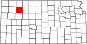 | |
|
Unincorporated communities | ||
| Ghost towns | ||
| Townships | ||
|
| This article about a location in Sheridan County, Kansas is a stub. You can help Wikipedia by expanding it. |