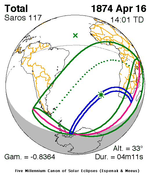
| Solar eclipse of April 16, 1874 | |
|---|---|
 Map | |
| Type of eclipse | |
| Nature | Total |
| Gamma | −0.8364 |
| Magnitude | 1.0569 |
| Maximum eclipse | |
| Duration | 251 s (4 min 11 s) |
| Coordinates | 39°54′S 0°54′W / 39.9°S 0.9°W |
| Max. width of band | 335 km (208 mi) |
| Times ( UTC) | |
| Greatest eclipse | 14:00:53 |
| References | |
| Saros | 117 (61 of 71) |
| Catalog # (SE5000) | 9220 |
A total solar eclipse occurred on Thursday, April 16, 1874. A solar eclipse occurs when the Moon passes between Earth and the Sun, thereby totally or partly obscuring the image of the Sun for a viewer on Earth. A total solar eclipse occurs when the Moon's apparent diameter is larger than the Sun's, blocking all direct sunlight, turning day into darkness. Totality occurs in a narrow path across Earth's surface, with the partial solar eclipse visible over a surrounding region thousands of kilometres wide.
Observations

Related eclipses
It is a part of solar Saros 117.
References
- NASA chart graphics
- Mabel Loomis Todd (1900). Total Eclipses of the Sun. Little, Brown.
.jpg)


Wikimedia Commons has media related to
Solar eclipse of 1874 April 16.