| Snowpatch Spire, The Bugaboos | |
|---|---|
 Snowpatch Spire, with
Pigeon Spire in the background on the right,
Hound's Tooth and
Marmolata Spire on the left. | |
| Highest point | |
| Elevation | 3,084 m (10,118 ft) [1] |
| Prominence | 284 m (932 ft) [2] |
| Parent peak | Howser Spire (3,412 m) [2] |
| Coordinates | 50°44′11″N 116°46′56″W / 50.73639°N 116.78222°W [3] |
| Geography | |
| Country | Canada |
| Province | British Columbia |
| District | Kootenay Land District |
| Protected area | Bugaboo Provincial Park |
| Parent range |
Purcell Mountains The Bugaboos |
| Topo map | NTS 82K10 Howser Creek |
| Geology | |
| Age of rock | 135 Million years ago [4] |
| Type of rock | Granodiorite [4] |
| Climbing | |
| First ascent | August 1940 by Raffi Bedayan and Jack Arnold [5] |
| Easiest route | class 5.8 [6] |
Snowpatch Spire is a mountain peak in British Columbia, Canada. With its first ascent in 1940, it was the last of the Bugaboo Spires to be climbed. [2] It is located southwest of the Conrad Kain hut, between Bugaboo, Vowell and Crescent Glaciers, at the south end of Bugaboo Provincial Park. [7] The mountain's toponym was officially adopted October 29, 1962, by the Geographical Names Board of Canada. [3]
Climate
Based on the Köppen climate classification, Snowpatch Spire is located in a subarctic climate zone with cold, snowy winters, and mild summers. [8] Winter temperatures can drop below −20 °C with wind chill factors below −30 °C.
Routes
Climbing routes on Snowpatch Spire: [9]
- Wildflowers - class 5.9
- Kraus-McCarthy - class 5.9
- Sunshine - class 5.11
- Surf's Up (aka Southwest Ridge) - class 5.9
- Southeast Corner (aka Snowpatch Route) - class 5.8
Gallery
-
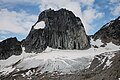 Northeast aspect
 -
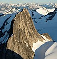 Snowpatch Spire seen from Bugaboo Spire
 -

-
-
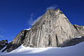
 Howser Spire (upper left), Snowpatch Spire (left of center), Bugaboo Spire (upper right), Eastpost Spire (lower right). Camera pointed west.
 -

-
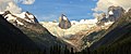 Anniversary Peak (left), Hound's Tooth/Marmolata Spire (centered) in Bugaboo Glacier, and Snowpatch Spire (right). East aspect as viewed from Bugaboo Lodge.


References
- ^ "Snowpatch Spire, British Columbia". Peakbagger.com. Retrieved 2023-02-05.
- ^ a b c "Snowpatch Spire, Peakvisor.com". Retrieved 2023-02-05.
- ^ a b "Snowpatch Spire". Geographical Names Data Base. Natural Resources Canada. Retrieved 2023-02-05.
- ^ a b Mary Caperton Morton (2017), Aerial Geology; A High-Altitude Tour of North America's Spectacular Volcanoes, Canyons, Glaciers, Lakes, Craters, and Peaks, Timber Press, ISBN 9781604698350, p. 42
- ^ Bedayan, Raffi (1941). A Bugaboo No Longer. American Alpine Journal Vol. 4, p. 219 (1941). Retrieved from http://publications.americanalpineclub.org/articles/12194121900/A-Bugaboo-No-Longer.
- ^ "Snowpatch Spire - 10,006' BC". listsofjohn.com. Retrieved 2020-11-10.
- ^ "Snowpatch Spire". BC Geographical Names. Retrieved 2023-02-05.
- ^ Peel, M. C.; Finlayson, B. L.; McMahon, T. A. (2007). "Updated world map of the Köppen−Geiger climate classification". Hydrol. Earth Syst. Sci. 11: 1633–1644. ISSN 1027-5606.
- ^ "Snowpatch Spire Rock Climbing, Mountainproject.com". Retrieved 2023-02-05.
External links
- "Snowpatch Spire". Bivouac.com.
- Snowpatch Spire weather: Mountain-forecast.com
Places adjacent to Snowpatch Spire | ||||||||||||||||
|---|---|---|---|---|---|---|---|---|---|---|---|---|---|---|---|---|
| ||||||||||||||||
|
| This article about a location in the Interior of British Columbia, Canada is a stub. You can help Wikipedia by expanding it. |