You can help expand this article with text translated from
the corresponding article in Dutch. (June 2010) Click [show] for important translation instructions.
|
Slotervaart
Tuinstad Slotervaart | |
|---|---|
Neighborhood of
Amsterdam | |
 Slotervaart as part of Amsterdam | |
| Country | Netherlands |
| Province | North Holland |
| Municipality | Amsterdam |
| Borough | Nieuw-West |
| Time zone | UTC+1 ( CET) |
| Area code | 020 |
Slotervaart (short for Tuinstad Slotervaart) is a neighborhood in the far western part of Amsterdam, Netherlands. The area is named after the canal Slotervaart; the first houses were built in 1955.
Just outside the residential area there is a hospital, the Slotervaartziekenhuis (since 1976), [1] and the Netherlands Cancer Institute (NKI) (since 1979). [2]
Since 1990 Slotervaart was a part of the urban district of Slotervaart-Overtoomse Veld, which was renamed in 2004 as shortly Slotervaart. In 2010 however this borough was merged with surrounding boroughs into the larger borough Amsterdam Nieuw-West.
-
 Bridge over Slotervaart canal
 -
 Apartment blocks Sloterhof
 -
 Apartment blocks, Pieter Calandlaan
 -
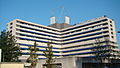 Slotervaartziekenhuis


References
- ^ Website Slotervaartziekenhuis Archived 2013-02-22 at archive.today
- ^ Website NKI
52°21′N 4°50′E / 52.350°N 4.833°E
|
| This North Holland location article is a stub. You can help Wikipedia by expanding it. |