| Skhodnya | |
|---|---|
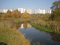
 Skhodnya River in
Zelenograd (Large City Pond) | |
| Native name | Сходня ( Russian) |
| Location | |
| Country | Russia |
| Physical characteristics | |
| Mouth | Moskva |
• coordinates | 55°49′24″N 37°24′44″E / 55.8234°N 37.4122°E |
| Length | 47 km (29 mi) |
| Basin size | 255 km2 (98 sq mi) |
| Basin features | |
| Progression | Moskva→ Oka→ Volga→ Caspian Sea |
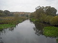
The Skhodnya ( Russian: Сходня, IPA: [ˈsxodʲnʲə]) is a river in the northwest of Moscow and Moscow Oblast, Russia. It is the second-largest tributary of the Moskva, after the Yauza. It is 47 kilometres (29 mi) long (of which 5 km in Moscow proper), and has a drainage basin of 255 square kilometres (98 sq mi). [1] The Skhodnya originates near the village of Alabushevo (part of Zelenograd) and flows into the Moskva River near the Tushino Airfield. The Skhodnya is connected with a derivational canal, which supplies water from the Volga through the Khimki Reservoir (with the help of the Skhodnenskaya hydroelectric plant) to Moscow for sanitary irrigation.
Gallery
-
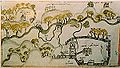 Plan 1692 (Drawing of land along the river Skhodnya near the village Kurkino)
 -

-

-

-
-
-


References
- ^ «Река СХОДНЯ», Russian State Water Registry
|
| This Moscow location article is a stub. You can help Wikipedia by expanding it. |
|
| This article related to a river in Russia is a stub. You can help Wikipedia by expanding it. |