| Sinopah Mountain | |
|---|---|
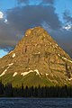
 Sinopah Mountain at right rises dramatically above the western end of
Two Medicine Lake | |
| Highest point | |
| Elevation | 8,276 ft (2,523 m) [1] |
| Prominence | 191 ft (58 m) [1] |
| Coordinates | 48°27′48″N 113°24′44″W / 48.46333°N 113.41222°W [2] |
| Geography | |
 Sinopah Mountain Location in Montana  Sinopah Mountain Location in the United States | |
| Location | Glacier County, Montana, U.S. |
| Parent range | Lewis Range |
| Topo map | USGS Mount Rockwell, MT |
| Climbing | |
| Easiest route | Scramble |
Sinopah Mountain (8,276 feet (2,523 m)) is located in the Lewis Range, Glacier National Park in the U.S. state of Montana. [3] Sinopah Mountain rises prominently to the west of Two Medicine Lake. Sinopah means, ""kit fox" in Blackfeet, (who) was the Indian wife of Hugh Monroe (Rising Wolf) and daughter of Lone Walker, a powerful Blackfeet chief." [4]
Geology
Like other mountains in Glacier National Park, the peak is composed of sedimentary rock laid down during the Precambrian to Jurassic periods. Formed in shallow seas, this sedimentary rock was initially uplifted beginning 170 million years ago when the Lewis Overthrust fault pushed an enormous slab of precambrian rocks 3 mi (4.8 km) thick, 50 miles (80 km) wide and 160 miles (260 km) long over younger rock of the cretaceous period. [5]
Climate
Based on the Köppen climate classification, the peak is located in an alpine subarctic climate zone with long, cold, snowy winters, and cool to warm summers. [6] Temperatures can drop below −10 °F with wind chill factors below −30 °F.
Gallery
-
 Sinopah and Two Medicine Lake
 -
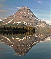
 Sinopah reflected in Two Medicine Lake
 -
 At sunrise
 -
-
 Sinopah and Two Medicine Lake
 -
 Sinopah


See also
References
- ^ a b "Sinopah Mountain, Montana". Peakbagger.com. Retrieved August 2, 2017.
- ^ "Sinopah Mountain". Geographic Names Information System. United States Geological Survey, United States Department of the Interior. Retrieved August 2, 2017.
- ^ Mount Rockwell, MT (Map). TopoQwest (United States Geological Survey Maps). Retrieved August 2, 2017.
- ^ "Historic Place Names". National Park Service. Retrieved August 2, 2017.
-
^ Gadd, Ben (2008). "Geology of the Rocky Mountains and Columbias".
{{
cite journal}}
: Cite journal requires|journal=( help) - ^ Peel, M. C.; Finlayson, B. L.; McMahon, T. A. (2007). "Updated world map of the Köppen−Geiger climate classification". Hydrol. Earth Syst. Sci. 11: 1633–1644. ISSN 1027-5606.
External links
- Weather forecast: Sinopah Mountain
|
| This Glacier County, Montana state location article is a stub. You can help Wikipedia by expanding it. |