Shoshone, Nevada | |
|---|---|
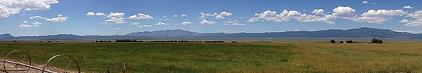
_about_1.7_miles_north_of_the_end_of_pavement_in_Shoshone,_Nevada.JPG) View along
SR 894 southbound in Shoshone | |
 Shoshone Location within the state of Nevada | |
| Coordinates: 38°51′14.4″N 114°23′31.8″W / 38.854000°N 114.392167°W | |
| Country | United States |
| State | Nevada |
| County | White Pine |
| Time zone | UTC-8 ( Pacific (PST)) |
| • Summer ( DST) | UTC-7 (PDT) |
Shoshone is a rural, unincorporated community in White Pine County, Nevada. It is at the south end of State Route 894, off of U.S. Route 93, just west of Great Basin National Park. The community consists of approximately nine ranches situated one to three miles apart in a long valley. The historic mine site of Minerva is located in Shoshone. [1] [2]
-
 Ranches in Shoshone
_about_1.1_miles_north_of_the_end_of_pavement-cropped.jpg)
References
- ^ "White Pine County Fire Plan - 18.0: Shoshone". Retrieved August 10, 2014.
- ^ "Minerva Nevada History". Retrieved August 10, 2014.
External links
-
 Media related to
Shoshone, Nevada at Wikimedia Commons
Media related to
Shoshone, Nevada at Wikimedia Commons
38°51′14.4″N 114°23′31.8″W / 38.854000°N 114.392167°W
|
| This White Pine County, Nevada state location article is a stub. You can help Wikipedia by expanding it. |