| Shamkirchay reservoir | |
|---|---|
 Shamkirchay reservoir | |
| Location | Shamkir District |
| Coordinates | 40°40′47″N 46°01′45″E / 40.67972°N 46.02917°E |
| Type | reservoir |
| Primary inflows | Shamkirchay |
| Primary outflows | Shamkirchay |
| Basin countries | Azerbaijan |
| Built | 2014 |
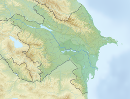
Shamkirchay reservoir [1] [2]( Azerbaijani: Şəmkirçay su anbarı) is an artificial reservoir in the Shamkir district of Azerbaijan. It is located on the slope of the Lesser Caucasus [1] on the Shamkirchay river. The volume of the reservoir is 164.5 million m³ [3] [4] (according to other sources - 164 million m³ [5] [6]). Useful volume considered - 156.3 million m³. [4]
The reservoir was commissioned in 2014. [4] [6] It is used for the irrigation of 70 thousand hectares of agricultural land, and also serves as a source of water for Shamkir and Ganja cities. [4] [5] [6] It also helps to protect the lower course of Kura from floods. [6]
The hydroelectric power plant located in the reservoir has a capacity of 24.4 MW. [4]
The climate in the vicinity of the reservoir is moderately warm, typical for dry steppes. [7] The average annual temperature is 12.9 °C, [7] the average July temperature is 23-26 °C, the maximum can reach 37-40 °C. [1] In winter, temperatures stay near freezing. [1] There are registered 350-600 mm of precipitation falls annually [7] (according to other sources - 240-390mm [1]). Evaporation makes 700-1100 mm. [7] The average annual air humidity is 67%. [7]
The soils in the reservoir basin are predominantly (80% of the area) gray-brown (chestnut), have a thickness of the fertile layer of 40-50 cm. [1]
See also
References
- ^ a b c d e f Садыхов Р. (2020). Агроэкологические свойства буро-коричневых (каштановых) почв бассейна Шамкирчайского водохранилища (PDF). Ryazan: Вестник Рязанского государственного агротехнологического университета имени П. А. Костычева. p. 43-49.
- ^ под ред. Г. И. Донидзе Шамкирча́й (1999). Шамкирча́й // Словарь названий гидрографических объектов России и других стран — членов СНГ (PDF). Moscow: Картгеоцентр — Геодезиздат. p. 438. ISBN 5-86066-017-0. Archived from the original (PDF) on 2016-03-06. Retrieved 2023-03-24.
-
^ Иманов Ф. А., Мамедов В. Г. — Екатеринбург, 2019. — С. 78—81. (2019).
Развитие систем водоснабжения и канализации в Азербайджане в начале XXI века (PDF).
Yekaterinburg: Чистая вода России. XV международный научно-практический симпозиум и выставка. Сборник материалов. p. 78—81.
{{
cite book}}
: CS1 maint: multiple names: authors list ( link) CS1 maint: numeric names: authors list ( link) - ^ a b c d e Иманов Ф. А., Алиева И. С. (2019). Оценка влияния антропогенных факторов на годовой сток рек Азербайджана (PDF). Водной хозяйство России. p. 20—31.
- ^
a
b Иманов Ф. А., Мамедов В. Г. (2019).
Развитие систем водоснабжения и канализации в Азербайджане в начале XXI века // Чистая вода России. XV международный научно-практический симпозиум и выставка. Сборник материалов (PDF).
Yekaterinburg. p. 78—81.
{{
cite book}}
: CS1 maint: location missing publisher ( link) - ^ a b c d Иманов Ф. А. (2016). Водные ресурсы и их использование в трансграничном бассейне р. Куры (PDF). Saint Petersburg: Свое издательство. p. 101—102.
- ^ a b c d e Садыхов Р. (2016). Влияние "магистральных каналов" нового Шамкирчайского водохранилища на почвенно-экологические условия бассейна. Успехи современной науки. p. 10—13.
