Semporna District
Daerah Semporna | |
|---|---|
 Semporna District Council office. | |
 Seal | |
 | |
| Coordinates: 4°29′00″N 118°37′00″E / 4.48333°N 118.61667°E | |
| Country | |
| State | |
| Division | Tawau |
| Capital | Semporna |
| Government | |
| • District Officer | A.M. Ibnu Haji A.K. Baba |
| Area | |
| • Total | 1,145 km2 (442 sq mi) |
| Population (2010) | |
| • Total | 133,164 |
| Website |
ww2 www |

The Semporna District ( Malay: Daerah Semporna) is an administrative district in the Malaysian state of Sabah, part of the Tawau Division which includes the districts of Kunak, Lahad Datu, Semporna and Tawau. The capital of the district is in Semporna Town.
Demographics
According to the last census in 2010, the population of Semporna district is estimated to be around 133,164 inhabitants. [1] As in other districts of Sabah, there are a significant number of illegal immigrants from the nearby southern Philippines, mainly from the Sulu Archipelago and Mindanao.
Climate
| Climate data for Semporna | |||||||||||||
|---|---|---|---|---|---|---|---|---|---|---|---|---|---|
| Month | Jan | Feb | Mar | Apr | May | Jun | Jul | Aug | Sep | Oct | Nov | Dec | Year |
| Mean daily maximum °C (°F) | 29.6 (85.3) |
29.7 (85.5) |
30.2 (86.4) |
30.9 (87.6) |
31.4 (88.5) |
31.3 (88.3) |
31.3 (88.3) |
31.5 (88.7) |
31.3 (88.3) |
31.2 (88.2) |
30.7 (87.3) |
30.1 (86.2) |
30.8 (87.4) |
| Daily mean °C (°F) | 26.2 (79.2) |
26.3 (79.3) |
26.6 (79.9) |
27.0 (80.6) |
27.3 (81.1) |
27.2 (81.0) |
27.0 (80.6) |
27.1 (80.8) |
27.0 (80.6) |
27.0 (80.6) |
26.8 (80.2) |
26.5 (79.7) |
26.8 (80.3) |
| Mean daily minimum °C (°F) | 22.9 (73.2) |
23.0 (73.4) |
23.1 (73.6) |
23.2 (73.8) |
23.3 (73.9) |
23.1 (73.6) |
22.8 (73.0) |
22.8 (73.0) |
22.8 (73.0) |
22.9 (73.2) |
23.0 (73.4) |
23.0 (73.4) |
23.0 (73.4) |
| Average rainfall mm (inches) | 201 (7.9) |
136 (5.4) |
135 (5.3) |
149 (5.9) |
210 (8.3) |
183 (7.2) |
160 (6.3) |
163 (6.4) |
124 (4.9) |
180 (7.1) |
194 (7.6) |
190 (7.5) |
2,025 (79.8) |
| Source: Climate-Data.org [2] | |||||||||||||
Gallery
-
 Semporna Town Mosque.
 -
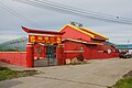 Sam Shen Temple.
 -
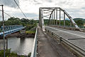 Pegagau Bridge.
 -
 Balimbang Asal.
 -
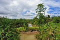 Gading River.


See also
References
- ^ "Population by ethnic group, Local Authority area and state, Malaysia" (PDF). Department of Statistics, Malaysia. 2010. Archived from the original (PDF) on 27 February 2012. Retrieved 5 November 2017.
- ^ "Climate: Semporna". Climate-Data.org. Retrieved 30 October 2020.
Further reading
- Treacher, W. H (1891). "British Borneo: sketches of Brunai, Sarawak, Labuan, and North Borneo". University of California Libraries. Singapore, Govt. print. dept. p. 190.
- Rutter, Owen (1922). "British North Borneo - An Account of its History, Resources and Native Tribes". Cornell University Libraries. Constable & Company Ltd, London. p. 157.
- Tregonning, K. G. (1965). A History Of Modern Sabah (North Borneo 1881–1963). University of Malaya Press.
External links
![]() Media related to
Semporna District at Wikimedia Commons
Media related to
Semporna District at Wikimedia Commons
- (in Malay) Semporna District Council
- (in Malay) Semporna District Office
Capital:
Kota Kinabalu | |||||||||||
| Topics | |||||||||||
| Society | |||||||||||
|
Administrative divisions |
| ||||||||||
|
| This Sabah location article is a stub. You can help Wikipedia by expanding it. |