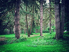
| Seaquest State Park | |
|---|---|
 | |
| Location | Cowlitz, Washington, United States |
| Coordinates | 46°17′54″N 122°49′05″W / 46.29833°N 122.81806°W [1] |
| Area | 505 acres (204 ha) |
| Elevation | 600 ft (180 m) [1] |
| Established | 1945 |
| Named for | Alfred L. Seaquest |
| Operator | Washington State Parks and Recreation Commission |
| Website | Seaquest State Park |
Seaquest State Park is a public recreation area located on the western flank of Silver Lake in Cowlitz County, Washington. [2] The 505-acre (204 ha) state park is home to the Mount St. Helens Visitor Center, which offers displays on the Mount St. Helens volcanic eruption of 1980. [3] Mount St. Helens itself is 30 miles (48 km) east of the park.
Activities and amenities
Park activities include camping, seven miles (11 km) of hiking trails (including one mile (1.6 km) of ADA-accessible trail), picnicking, bird watching, and horseshoes. The park has a mile-long shoreline on Silver Lake, a shallow lowland lake with wetlands trail and boardwalk, [2] boat launch, and fishing. [4]
References
- ^ a b "Seaquest State Park". Geographic Names Information System. United States Geological Survey, United States Department of the Interior.
- ^ a b "Seaquest State Park". Washington State Parks and Recreation Commission. Retrieved February 11, 2016.
- ^ "Mount St. Helens Visitor Center". Washington State Parks and Recreation Commission. Retrieved February 11, 2016.
- ^ "Silver Lake". Fishing & Shellfishing. Washington Department of Fish and Wildlife. Retrieved February 11, 2016.
External links
Wikimedia Commons has media related to
Seaquest State Park.
- Seaquest State Park Washington State Parks and Recreation Commission
- Seaquest State Park Map Washington State Parks and Recreation Commission

