Sarapuí | |
|---|---|
Municipality | |
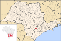
 Location in São Paulo state | |
| Coordinates: 23°38′26″S 47°49′29″W / 23.64056°S 47.82472°W | |
| Country | |
| Region | Southeast Brazil |
| State | São Paulo |
| Metropolitan Region | Sorocaba |
| Area | |
| • Total | 352.53 km2 (136.11 sq mi) |
| Elevation | 590 m (1,940 ft) |
| Population (2020
[1]) | |
| • Total | 10,390 |
| • Density | 29/km2 (76/sq mi) |
| Time zone | UTC−3 ( BRT) |
Sarapuí is a municipality in the state of São Paulo in Brazil. It is part of the Metropolitan Region of Sorocaba. [2] The population is 10,390 (2020 est.) in an area of 352.53 km². [3] The elevation is 590 m.
References
- ^ IBGE 2020
-
^
"Governo do Estado de São Paulo, Lei Complementar nº 1.241, de 8 de maio de 2014". Archived from the original on 18 October 2014. Retrieved 2015-09-29.
{{
cite web}}
: CS1 maint: bot: original URL status unknown ( link) - ^ Instituto Brasileiro de Geografia e Estatística


