Sanderson, Florida | |
|---|---|
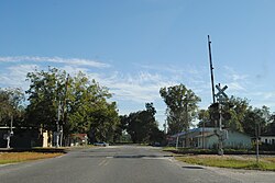
 Southbound on Baker CR 229 at the Tallahassee Subdivision Railroad Crossing. | |
| Coordinates: 30°15′08″N 82°16′22″W / 30.25222°N 82.27278°W | |
| Country | United States |
| State | Florida |
| County | Baker |
| Elevation | 157 ft (48 m) |
| Time zone | UTC-5 ( Eastern (EST)) |
| • Summer ( DST) | UTC-4 (EDT) |
| ZIP code | 32087
[1] |
| Area code | 904 |
| GNIS feature ID | 306352 [2] |
Sanderson is a town in Baker County, Florida, United States. The main road through Sanderson is U.S. Route 90, which is intersected by County Roads 229 and 127. Sanderson is also the headquarters of the Baker County Road Department. The town was named after John Pease Sanderson.
Sanderson is home to a cannabis cultivation facility, as well as several other small manufacturing concerns, due to the towns easy access to I10.
References
- ^ "Sanderson ZIP Code". zipdatamaps.com. 2022. Retrieved November 30, 2022.
- ^ "Sanderson". Geographic Names Information System. United States Geological Survey, United States Department of the Interior.
External links

