-
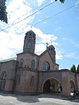 San Isidro Labrador Church
 -
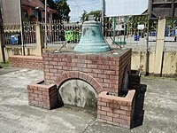 M.R.P.F. Paulino Escalada 1836 bells
 -
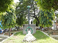 Central Park
 -
 Barangay Malapit Hall
 -
 Nueva Ecija University of Science and Technology
 -
 The Crispulo Sideco (also known as Kapitang Pulong) house was built in the 19th century. Built in the Floral period in the Philippine colonial architecture, ogee arches, filigreed wooden panels, grilles wrought in curlicues and floral and foliate designs abound in the house as basic structural elements or as ornaments.
San Isidro | |
|---|---|
| Municipality of San Isidro | |
 Municipal hall | |
 Seal | |
 Map of Nueva Ecija with San Isidro highlighted | |
.svg) San Isidro Location within the
Philippines | |
| Coordinates: 15°18′35″N 120°54′25″E / 15.3097°N 120.9069°E | |
| Country | Philippines |
| Region | Central Luzon |
| Province | Nueva Ecija |
| District | 4th district |
| Barangays | 9 (see Barangays) |
| Government | |
| • Type | Sangguniang Bayan |
| • Mayor | Florentino C. Tinio |
| • Vice Mayor | John Carlo A. Patiag |
| • Representative | Emerson D. Pascual |
| • Municipal Council | Members |
| • Electorate | 33,813 voters ( 2022) |
| Area | |
| • Total | 56.49 km2 (21.81 sq mi) |
| Elevation | 21 m (69 ft) |
| Highest elevation | 35 m (115 ft) |
| Lowest elevation | 12 m (39 ft) |
| Population (2020 census)
[3] | |
| • Total | 54,372 |
| • Density | 960/km2 (2,500/sq mi) |
| • Households | 12,828 |
| Economy | |
| • Income class | 2nd municipal income class |
| • Poverty incidence | 4.63 |
| • Revenue | ₱ 181.6 million (2020) |
| • Assets | ₱ 568.2 million (2020) |
| • Expenditure | ₱ 173.5 million (2020) |
| • Liabilities | ₱ 282.2 million (2020) |
| Service provider | |
| • Electricity | Nueva Ecija 1 Electric Cooperative (NEECO 1) |
| Time zone | UTC+8 ( PST) |
| ZIP code | 3106 |
| PSGC | |
| IDD : area code | +63 (0)44 |
| Native languages | Kapampangan Tagalog Ilocano |
San Isidro, officially the Municipality of San Isidro ( Tagalog: Bayan ni San Isidro, Kapampangan: Balen ning San Isidro), is a 2nd class municipality in the province of Nueva Ecija, Philippines. According to the 2020 census, it has a population of 54,372 people. [3]
The municipality is bounded by Gapan to the east, the municipalities of San Leonardo and Jaen to the north, San Antonio to the west, Cabiao to the south-west, San Miguel, Bulacan, to the southeast and Candaba, Pampanga, to the south.
San Isidro became the capital of the Philippines during the First Republic while President Emilio Aguinaldo was moving north to avoid being captured by American forces.
History
San Isidro was the capital of Nueva Ecija from 1852 to 1912. [5] San Isidro, along with its origin Gapan, Aliaga, Cabiao, and San Antonio were transferred from Pampanga to Nueva Ecija in 1848. After the first cry against the Spanish colonial government was made in 1896, there were 2,000 revolutionary soldiers under General Mariano Llanera who sieged San Isidro. [6]
On March 29, 1899, General Emilio Aguinaldo declared San Isidro as the capital of the Philippines [5] after the revolutionary capital Malolos, Bulacan was captured by the Americans. However, this was short-lived. General Frederick Funston planned the capture of Aguinaldo to end the Philippine–American War, in San Isidro.
The Wright Institute, established in 1903 in San Isidro, was the first high school established outside Manila during the American period. [6]
The town was occupied by Japanese troops in 1942, during World War II. The combined U.S. and Philippine Commonwealth ground forces liberated San Isidro and defeated the Japanese forces in 1945 during the end of the war.[ citation needed]
Contemporary period
On September 11, 1989, Mayor Enrique Lorenzo was on his way back from Manila to San Isidro with his wife Aurora, their driver and one of their security personnel when they were ambushed by four gunmen along the Sta. Mesa Bridge. [7] Aurora and the two other companions died from their gunshot wounds while Mayor Lorenzo survived the attempted assassination with only his left shoulder wounded. [7]
Geography
Barangays
San Isidro is divided into nine barangays. Each barangay consists of puroks and some have sitios.
- Alua
- Calaba
- Malapit
- Mangga
- Poblacion
- Pulo
- San Roque
- Santo Cristo
- Tabon
Climate
| Climate data for San Isidro, Nueva Ecija | |||||||||||||
|---|---|---|---|---|---|---|---|---|---|---|---|---|---|
| Month | Jan | Feb | Mar | Apr | May | Jun | Jul | Aug | Sep | Oct | Nov | Dec | Year |
| Mean daily maximum °C (°F) | 29 (84) |
30 (86) |
31 (88) |
34 (93) |
33 (91) |
31 (88) |
30 (86) |
29 (84) |
29 (84) |
30 (86) |
30 (86) |
29 (84) |
30 (87) |
| Mean daily minimum °C (°F) | 20 (68) |
20 (68) |
20 (68) |
22 (72) |
24 (75) |
24 (75) |
24 (75) |
24 (75) |
24 (75) |
23 (73) |
22 (72) |
21 (70) |
22 (72) |
| Average precipitation mm (inches) | 4 (0.2) |
4 (0.2) |
5 (0.2) |
11 (0.4) |
66 (2.6) |
99 (3.9) |
127 (5.0) |
113 (4.4) |
99 (3.9) |
84 (3.3) |
35 (1.4) |
14 (0.6) |
661 (26.1) |
| Average rainy days | 2.2 | 1.9 | 3.2 | 5.3 | 16.1 | 20.8 | 23.5 | 22.8 | 22.2 | 16.5 | 8.9 | 3.5 | 146.9 |
| Source: Meteoblue [8] | |||||||||||||
Demographics
|
| |||||||||||||||||||||||||||||||||||||||||||||||||||
| Source: Philippine Statistics Authority [9] [10] [11] [12] | ||||||||||||||||||||||||||||||||||||||||||||||||||||
Religion
Majority of populace is Roman Catholic. Other religious groups have churches and places of worship.
Economy
Poverty Incidence of San Isidro
Graphs are unavailable due to technical issues. There is more info on
Phabricator and on
MediaWiki.org. |
Primarily depends on rice & vegetable farming, poultry and piggery.
As of 2017, based on Commission on Audit of the Philippines, San Isidro reached their income of P129,676,820.86; assets of P494,469,351.35; liabilities of P229,800,110.14 and allotments of P135,154,456.00. [20]
Tourism
- Carron Dreampark is an amusement and theme park in Barangay Santo Cristo, and was opened on November 17, 2012.
- JF Sports Complex & Resort in Barangay Poblacion.
- YES Cookery in Barangay Poblacion
Education
- Nueva Ecija University of Science and Technology, San Isidro Campus: started as a vocational course at the Wright Institute in San Isidro, Nueva Ecija where young Filipinos were trained in woodworking and basic telegraphy. This vocational course lasted until S.Y. 1927-1928 when the general secondary education course was transferred to Cabanatuan. On June 9, 1929, the school was renamed Nueva Ecija Trade School (NETS) in accordance with Vocational Education Act 3377 of 1929. The NETS was based in San Isidro, Nueva Ecija, offering vocational opportunities to the youth of the province. The first and only vocational course being offered then was woodworking. That course was an addition to the existing secondary curriculum inherited from the Wright Institute.
- General de Jesus College: formerly known as General de Jesus Academy, is a private school located in the Poblacion, San Isidro, Nueva Ecija, the Philippines. It was founded in 1946.
- Holy Rosary Colleges Foundation: private school at Calaba, San Isidro, Nueva Ecija.
Gallery


References
- ^ Municipality of San Isidro | (DILG)
- ^ "2015 Census of Population, Report No. 3 – Population, Land Area, and Population Density" (PDF). Philippine Statistics Authority. Quezon City, Philippines. August 2016. ISSN 0117-1453. Archived (PDF) from the original on May 25, 2021. Retrieved July 16, 2021.
- ^ a b Census of Population (2020). "Region III (Central Luzon)". Total Population by Province, City, Municipality and Barangay. Philippine Statistics Authority. Retrieved July 8, 2021.
- ^ "PSA Releases the 2018 Municipal and City Level Poverty Estimates". Philippine Statistics Authority. December 15, 2021. Retrieved January 22, 2022.
- ^ a b Navasero, Mandy (September 29, 2001). "Mayor Sonia Lorenzo and historic San Isidro". Philippine Daily Inquirer. Retrieved January 20, 2016.
- ^ a b "San Isidro History". Official Website of Municipal Government of San Isidro, Nueva Ecija. San Isidro, Nueva Ecija Municipal Government. Retrieved January 20, 2016.
- ^ a b Ignacio, Bert (September 12, 1989). "Nueva Ecija mayor ambushed on Manila bridge". Manila Standard. Kagitingan Publications, Inc. p. 9. Retrieved December 31, 2022.
- ^ "San Isidro: Average Temperatures and Rainfall". Meteoblue. Retrieved May 4, 2020.
- ^ Census of Population (2015). "Region III (Central Luzon)". Total Population by Province, City, Municipality and Barangay. Philippine Statistics Authority. Retrieved June 20, 2016.
- ^ Census of Population and Housing (2010). "Region III (Central Luzon)" (PDF). Total Population by Province, City, Municipality and Barangay. National Statistics Office. Retrieved June 29, 2016.
-
^ Censuses of Population (1903–2007).
"Region III (Central Luzon)".
Table 1. Population Enumerated in Various Censuses by Province/Highly Urbanized City: 1903 to 2007.
National Statistics Office.
{{
cite encyclopedia}}
: CS1 maint: numeric names: authors list ( link) - ^ "Province of Nueva Ecija". Municipality Population Data. Local Water Utilities Administration Research Division. Retrieved December 17, 2016.
- ^ "Poverty incidence (PI):". Philippine Statistics Authority. Retrieved December 28, 2020.
- ^ "Estimation of Local Poverty in the Philippines" (PDF). Philippine Statistics Authority. November 29, 2005.
- ^ "2003 City and Municipal Level Poverty Estimates" (PDF). Philippine Statistics Authority. March 23, 2009.
- ^ "City and Municipal Level Poverty Estimates; 2006 and 2009" (PDF). Philippine Statistics Authority. August 3, 2012.
- ^ "2012 Municipal and City Level Poverty Estimates" (PDF). Philippine Statistics Authority. May 31, 2016.
- ^ "Municipal and City Level Small Area Poverty Estimates; 2009, 2012 and 2015". Philippine Statistics Authority. July 10, 2019.
- ^ "PSA Releases the 2018 Municipal and City Level Poverty Estimates". Philippine Statistics Authority. December 15, 2021. Retrieved January 22, 2022.
- ^ "Annual Audit Report". Commission on Audit. Retrieved October 20, 2018.
External links
Wikimedia Commons has media related to
San Isidro, Nueva Ecija.
- San Isidro Official Website
- Philippine Standard Geographic Code
- Philippine Census Information
- Local Governance Performance Management System
Places adjacent to San Isidro, Nueva Ecija | |
|---|---|
| Municipalities | |
|---|---|
| Component cities | |
| International | |
|---|---|
| National | |