San Ildefonso | |
|---|---|
| Municipality of San Ildefonso | |
 Welcome Arch | |
 Flag  Seal | |
 Map of Bulacan with San Ildefonso highlighted | |
.svg) San Ildefonso Location within the
Philippines | |
| Coordinates: 15°04′44″N 120°56′31″E / 15.07889°N 120.94194°E | |
| Country | Philippines |
| Region | Central Luzon |
| Province | Bulacan |
| District | 3rd district |
| Founded | 1875 |
| Named for | Saint Ildefonsus |
| Barangays | 36 (see Barangays) |
| Government | |
| • Type | Sangguniang Bayan |
| • Mayor | Fernando S. Galvez Jr. |
| • Vice Mayor | Rocky G. Sarmiento |
| • Representative | Lorna C. Silverio |
| • Municipal Council | Members |
| • Electorate | 76,231 voters ( 2022) |
| Area | |
| • Total | 128.71 km2 (49.70 sq mi) |
| Elevation | 19 m (62 ft) |
| Highest elevation | 51 m (167 ft) |
| Lowest elevation | 7 m (23 ft) |
| Population (2020 census)
[3] | |
| • Total | 115,713 |
| • Density | 900/km2 (2,300/sq mi) |
| • Households | 29,301 |
| Economy | |
| • Income class | 1st municipal income class |
| • Poverty incidence | 5.54 |
| • Revenue | ₱ 512.8 million (2020) |
| • Assets | ₱ 1,222 million (2020) |
| • Expenditure | ₱ 460.7 million (2020) |
| • Liabilities | ₱ 642.3 million (2020) |
| Utilities | |
| • Electricity | Meralco |
| Time zone | UTC+8 ( PST) |
| ZIP code | 3010 |
| PSGC | |
| IDD : area code | +63 (0)44 |
| Native languages | Tagalog Kapampangan |
San Ildefonso, officially the Municipality of San Ildefonso ( Tagalog: Bayan ng San Ildefonso) is a 1st class municipality in the province of Bulacan, Philippines. According to the 2020 census, it has a population of 115,713 people. [3]
With the continuous expansion of Metro Manila, the municipality is the northernmost part of Manila's built-up area.
San Ildefonso is 43 kilometers (27 mi) from Malolos and 66 kilometers (41 mi) from Manila.
History

The early inhabitants called this town Bulak because of the abundant 'kapok' trees ('bulak' in vernacular) growing on the hill where the town is now.
Bulak was then a barrio of San Rafael. There were only about 3,000 inhabitants. The early inhabitants were people from neighboring towns and provinces who preferred to settle in this place because of its good agricultural prospects.
When the Spaniards came, the name Bulak was changed to Hacienda San Juan de Dios because 15,500 hectares of grazing and farming grounds were claimed by the friars. The people were told to pay tribute. Proceeds from the rentals were used to finance the operation of the San Juan de Dios Hospital in Manila. The Spanish friars, though antagonistic toward the Filipinos, admired the beauty of the natural scenery. They changed the name to Hacienda Buenavista (which means beautiful scenery in Spanish).
As the population grew, a chapel was constructed under the parochial jurisdiction of San Rafael. In 1809, Father Juan dela Rosa was named the first Filipino priest of the town. He held the position until 1811. He was responsible for changing the name Bulak to San Ildefonso in honor of Alfonso XII, then the king of Spain, and San Ildefonso, its patron saint. By the time it was given this name, a tribunal was created finally making it a town in 1877. Between 1903 and 1906, San Ildefonso was merged with San Miguel due to its low income and inability to finance its expenditures in operating the local government. [5]
As years went by, more and more people were induced to live in the town. The growth of population promoted an increase of income. The town became capable of meeting its expenses so it ceased being a barrio of San Miguel and became once again an independent town. [6]
During the Japanese occupation of the Philippines in 1942 the mansion Bahay na Pula of the Ilusorio family was confiscated by the Imperial Japanese Army and used as barracks and became a place where local so-called comfort women were forced to work. [7]
Geography
Barangays
San Ildefonso is politically subdivided into 36 barangays. Each barangay consist of 7 puroks and some have sitios.
There are 6 urban and 30 rural barangays.
| PSGC | Barangay | Population | ±% p.a. | |||
|---|---|---|---|---|---|---|
| 2020 [3] | 2010 [8] | |||||
| 031419001 | Akle | 3.7% | 4,330 | 3,320 | 2.69% | |
| 031419002 | Alagao | 3.0% | 3,506 | 3,119 | 1.18% | |
| 031419003 | Anyatam | 3.6% | 4,169 | 3,887 | 0.70% | |
| 031419006 | Bagong Barrio | 1.9% | 2,150 | 2,087 | 0.30% | |
| 031419007 | Basuit | 1.8% | 2,068 | 1,961 | 0.53% | |
| 031419008 | Bubulong Munti | 1.9% | 2,245 | 2,078 | 0.78% | |
| 031419009 | Bubulong Malaki | 1.8% | 2,069 | 1,984 | 0.42% | |
| 031419010 | Buhol na Mangga | 1.2% | 1,402 | 1,302 | 0.74% | |
| 031419011 | Bulusukan | 1.7% | 1,948 | 1,814 | 0.72% | |
| 031419012 | Calasag | 3.1% | 3,578 | 3,237 | 1.01% | |
| 031419013 | Calawitan | 3.0% | 3,435 | 2,824 | 1.98% | |
| 031419014 | Casalat | 1.6% | 1,811 | 1,629 | 1.06% | |
| 031419015 | Gabihan | 2.9% | 3,393 | 3,298 | 0.28% | |
| 031419016 | Garlang | 1.0% | 1,183 | 1,082 | 0.90% | |
| 031419017 | Lapnit | 2.7% | 3,134 | 3,110 | 0.08% | |
| 031419018 | Maasim | 3.3% | 3,774 | 2,907 | 2.64% | |
| 031419019 | Makapilapil | 1.9% | 2,234 | 2,697 | −1.87% | |
| 031419020 | Malipampang | 5.1% | 5,897 | 5,525 | 0.65% | |
| 031419021 | Matimbubong | 2.2% | 2,583 | 2,563 | 0.08% | |
| 031419022 | Nabaong Garlang | 1.7% | 1,914 | 1,790 | 0.67% | |
| 031419023 | Palapala | 5.3% | 6,087 | 5,348 | 1.30% | |
| 031419024 | Pasong Bangkal | 0.7% | 839 | 744 | 1.21% | |
| 031419025 | Pinaod | 6.3% | 7,283 | 6,545 | 1.07% | |
| 031419026 | Poblacion | 3.5% | 4,080 | 3,644 | 1.14% | |
| 031419027 | Pulong Tamo | 1.7% | 1,987 | 1,813 | 0.92% | |
| 031419028 | San Juan | 4.4% | 5,149 | 4,337 | 1.73% | |
| 031419029 | Santa Catalina Bata | 1.3% | 1,502 | 1,177 | 2.47% | |
| 031419030 | Santa Catalina Matanda | 2.3% | 2,620 | 2,497 | 0.48% | |
| 031419031 | Sapang Dayap | 1.3% | 1,483 | 1,447 | 0.25% | |
| 031419032 | Sapang Putik | 3.4% | 3,946 | 3,935 | 0.03% | |
| 031419033 | Sapang Putol | 1.7% | 1,988 | 2,073 | −0.42% | |
| 031419034 | Sumandig | 2.0% | 2,257 | 1,966 | 1.39% | |
| 031419035 | Telapatio | 0.9% | 1,020 | 903 | 1.23% | |
| 031419036 | Upig | 2.2% | 2,524 | 2,225 | 1.27% | |
| 031419037 | Umpucan | 2.1% | 2,423 | 1,787 | 3.09% | |
| 031419038 | Mataas na Parang | 2.1% | 2,460 | 2,345 | 0.48% | |
| Total | 115,713 | 95,000 | 1.99% | |||
Climate
| Climate data for San Ildefonso, Bulacan | |||||||||||||
|---|---|---|---|---|---|---|---|---|---|---|---|---|---|
| Month | Jan | Feb | Mar | Apr | May | Jun | Jul | Aug | Sep | Oct | Nov | Dec | Year |
| Mean daily maximum °C (°F) | 28 (82) |
29 (84) |
31 (88) |
33 (91) |
32 (90) |
31 (88) |
30 (86) |
29 (84) |
29 (84) |
30 (86) |
30 (86) |
28 (82) |
30 (86) |
| Mean daily minimum °C (°F) | 20 (68) |
20 (68) |
21 (70) |
22 (72) |
24 (75) |
24 (75) |
24 (75) |
24 (75) |
24 (75) |
23 (73) |
22 (72) |
21 (70) |
22 (72) |
| Average precipitation mm (inches) | 6 (0.2) |
4 (0.2) |
6 (0.2) |
17 (0.7) |
82 (3.2) |
122 (4.8) |
151 (5.9) |
123 (4.8) |
124 (4.9) |
99 (3.9) |
37 (1.5) |
21 (0.8) |
792 (31.1) |
| Average rainy days | 3.3 | 2.5 | 11.7 | 6.6 | 17.7 | 22.2 | 25.2 | 23.7 | 23.2 | 17.9 | 9.2 | 5.2 | 168.4 |
| Source: Meteoblue [9] | |||||||||||||
Demographics
| Year | Pop. | ±% p.a. |
|---|---|---|
| 1903 | 5,326 | — |
| 1918 | 9,190 | +3.70% |
| 1939 | 16,395 | +2.79% |
| 1948 | 18,288 | +1.22% |
| 1960 | 26,140 | +3.02% |
| 1970 | 34,559 | +2.83% |
| 1975 | 39,593 | +2.76% |
| 1980 | 44,931 | +2.56% |
| 1990 | 59,598 | +2.87% |
| 1995 | 69,319 | +2.87% |
| 2000 | 79,956 | +3.11% |
| 2007 | 93,438 | +2.17% |
| 2010 | 95,000 | +0.61% |
| 2015 | 104,471 | +1.83% |
| 2020 | 115,713 | +2.03% |
| Source: Philippine Statistics Authority [10] [8] [11] [12] | ||
In the 2020 census, the population of San Ildefonso, Bulacan, was 115,713 people, [3] with a density of 900 inhabitants per square kilometer or 2,300 inhabitants per square mile.
Economy
Graphs are unavailable due to technical issues. There is more info on
Phabricator and on
MediaWiki.org. |
|
|
Education
Public Schools
Elementary Education
The town has numerous public schools offering elementary and high school education. Some of the elementary public schools are:
- South District
| No | Name |
|---|---|
| 1 | Pinaod ES |
| 2 | Malipampang ES |
| 3 | Maasim ES |
| 4 | Palapala ES |
| 5 | Gabihan ES |
| 6 | Akle ES |
| 7 | Sapang Putik ES |
| 8 | Basuit ES |
| 9 | Upig ES |
| 10 | Bagong Baryo Es |
| 11 | Alagao ES |
| 12 | Matimbubong ES |
| 13 | Casalat ES |
| 14 | Sitio Pag- Asa ES |
| 15 | Narra ES |
| 16 | Sitio Biga ES |
| 17 | Pasong Bangkal ES (Satellite School) |
- North District
| No | Name |
|---|---|
| 1 | San Ildefonso ES |
| 2 | Anyatam ES |
| 3 | Bubulong Malaki ES |
| 4 | Bubulong Munti ES |
| 5 | Bulusukan ES |
| 6 | Calawitan ES |
| 7 | Makapilapil ES |
| 8 | Pulong Tamo ES |
| 9 | Sumandig ES |
| 10 | Santa Catalina Mat. ES |
| 11 | Umpucan ES |
| 12 | Nabaong Garlang ES |
| 13 | Calasag ES |
| 14 | Lapnit ES |
| 15 | San Juan ES |
| 16 | Mataas na Parang ES |
| 17 | Buhol na Mangga ES |
| 18 | Garlang ES |
| 19 | Santa Catalina Bata ES |
| 20 | Telapatio PS |
Secondary Education
Some of the public high schools are:
| No | Name |
|---|---|
| 1 | San Ildefonso National High School |
| 2 | Calawitan National High School |
| 3 | Akle High School |
| 4 | Santa Catalina High School |
| 5 | Upig High school |
Tertiary and College Education
Some of the tertiary schools are:
| No | Name |
|---|---|
| 1 | Bulacan Agricultural State College |
Private Schools
Some of the private schools offering education
| No | Name | Nursery & Kindergarten | Elementary | Secondary | Senior High School | Tertiary / College |
|---|---|---|---|---|---|---|
| 1 | AMG Skilled Hands Technological College (ASHTEC) | Yes | Yes | Yes | ||
| 2 | Motessori De San Ildefonso | Yes | Yes | Yes | ||
| 3 | Saint Paul School of San Ildefonso | Yes | ||||
| 4 | Saint John School | Yes | Yes | Yes | ||
| 5 | Liceo De Buenavista | Yes | Yes | |||
| 6 | Goldenville School of Montessori | Yes | Yes | Yes | ||
| 7 | Veritas Learning Center | Yes | ||||
| 8 | Solagracia Alliance School, Inc. | Yes |
Notable personalities
- Yuka Saso – 2021 U.S. Women's Open Golf Champion. Filipino Japanese amateur golfer. Two-time Asian Games gold medalist in individual and team events.
- Paula Carla Galvez-Tan – former town Mayor (2010-2013, 2016-2022) who grew popularity because of her efforts during the COVID-19 pandemic
- Cardozo Luna – politician; Undersecretary of Department National Defence.
- Joyce Ching – Filipino-Chinese actress
Gallery
-
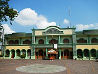 Municipal hall
 -
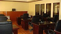 Sanguniang Bayan Session Hall
 -
 San Ildefonso (MPS) - PNP Police Regional Office 1
 -
 St. Ildephonsus of Toledo Church (Poblacion)


References
- ^ Municipality of San Ildefonso | (DILG)
- ^ "2015 Census of Population, Report No. 3 – Population, Land Area, and Population Density" (PDF). Philippine Statistics Authority. Quezon City, Philippines. August 2016. ISSN 0117-1453. Archived (PDF) from the original on May 25, 2021. Retrieved July 16, 2021.
- ^ a b c d Census of Population (2020). "Region III (Central Luzon)". Total Population by Province, City, Municipality and Barangay. Philippine Statistics Authority. Retrieved 8 July 2021.
- ^ "PSA Releases the 2018 Municipal and City Level Poverty Estimates". Philippine Statistics Authority. 15 December 2021. Retrieved 22 January 2022.
- ^ Act No. 932 (8 October 1903), "An Act Reducing the Twenty-five Municipalities of the Province of Bulacan to Thirteen", Senate of the Philippines Legislative Digital Resources, retrieved July 3, 2023
- ^ "Bulacan, Philippines: San Ildefonso, Bulacan: History".
- ^ "The house where the Philippines' forgotten 'comfort women' were held". BBC News. 16 June 2016.
- ^ a b Census of Population and Housing (2010). "Region III (Central Luzon)" (PDF). Total Population by Province, City, Municipality and Barangay. National Statistics Office. Retrieved 29 June 2016.
- ^ "San Ildefonso: Average Temperatures and Rainfall". Meteoblue. Retrieved 12 May 2020.
- ^ Census of Population (2015). "Region III (Central Luzon)". Total Population by Province, City, Municipality and Barangay. Philippine Statistics Authority. Retrieved 20 June 2016.
-
^ Censuses of Population (1903–2007).
"Region III (Central Luzon)".
Table 1. Population Enumerated in Various Censuses by Province/Highly Urbanized City: 1903 to 2007.
National Statistics Office.
{{
cite encyclopedia}}
: CS1 maint: numeric names: authors list ( link) - ^ "Province of Bulacan". Municipality Population Data. Local Water Utilities Administration Research Division. Retrieved 17 December 2016.
- ^ "Poverty incidence (PI):". Philippine Statistics Authority. Retrieved December 28, 2020.
- ^ "Estimation of Local Poverty in the Philippines" (PDF). Philippine Statistics Authority. 29 November 2005.
- ^ "2003 City and Municipal Level Poverty Estimates" (PDF). Philippine Statistics Authority. 23 March 2009.
- ^ "City and Municipal Level Poverty Estimates; 2006 and 2009" (PDF). Philippine Statistics Authority. 3 August 2012.
- ^ "2012 Municipal and City Level Poverty Estimates" (PDF). Philippine Statistics Authority. 31 May 2016.
- ^ "Municipal and City Level Small Area Poverty Estimates; 2009, 2012 and 2015". Philippine Statistics Authority. 10 July 2019.
- ^ "PSA Releases the 2018 Municipal and City Level Poverty Estimates". Philippine Statistics Authority. 15 December 2021. Retrieved 22 January 2022.
Further reading
- De los Reyes, Angelo J.; De los Reyes, Aloma Monte (1983). Bulac noon, San Ildefonso ngayon. San Ildefonso, Bulacan: Normine Printing House.
External links
- Philippine Standard Geographic Code
- San Ildefonso municipal website
- 2007 Philippine Census Information
Places adjacent to San Ildefonso, Bulacan | ||||||||||||||||
|---|---|---|---|---|---|---|---|---|---|---|---|---|---|---|---|---|
| ||||||||||||||||
| Municipalities | |
|---|---|
| Component cities | |