(Redirected from
Saint-Sulpice, Tarn)
Saint-Sulpice-la-Pointe | |
|---|---|
.png) An aerial view of Saint-Sulpice | |
.svg) Coat of arms | |
 Saint-Sulpice-la-Pointe  Saint-Sulpice-la-Pointe | |
| Coordinates: 43°46′30″N 1°41′14″E / 43.775°N 1.6872°E | |
| Country | France |
| Region | Occitania |
| Department | Tarn |
| Arrondissement | Castres |
| Canton | Les Portes du Tarn |
| Intercommunality | Tarn-Agout |
| Government | |
| • Mayor (2020–2026) | Raphaël Bernardin [1] |
| Area 1 | 23.99 km2 (9.26 sq mi) |
| Population (2021)
[2] | 9,576 |
| • Density | 400/km2 (1,000/sq mi) |
| Time zone | UTC+01:00 ( CET) |
| • Summer ( DST) | UTC+02:00 ( CEST) |
| INSEE/Postal code |
81271 /81370 |
| Elevation | 95–195 m (312–640 ft) (avg. 112 m or 367 ft) |
| 1 French Land Register data, which excludes lakes, ponds, glaciers > 1 km2 (0.386 sq mi or 247 acres) and river estuaries. | |
Saint-Sulpice-la-Pointe (French pronunciation: [sɛ̃ sylpis la pwɛ̃t], before 2013: Saint-Sulpice; Languedocien: Sant Somplesi) [3] is a commune in the Tarn department in southern France. During World War 2 a concentration camp was built in this town.
Population
| Year | Pop. | ±% p.a. |
|---|---|---|
| 1968 | 2,841 | — |
| 1975 | 3,342 | +2.35% |
| 1982 | 3,877 | +2.14% |
| 1990 | 4,354 | +1.46% |
| 1999 | 4,801 | +1.09% |
| 2007 | 7,612 | +5.93% |
| 2012 | 8,327 | +1.81% |
| 2017 | 9,117 | +1.83% |
| Source: INSEE [4] | ||
Transport
Saint-Sulpice station has rail connections to Toulouse, Rodez, Aurillac and Castres.
Remarkable places and monuments
-
 Town hall
 -
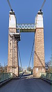 The suspension bridge over the Agout.
 -
 War memorial.
 -
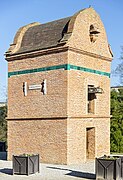 Dovecote from 1810
 -
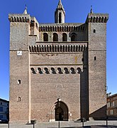 Church Notre-Dame
 -
 View of the nave
_-_Mairie.jpg)
_-_le_pont_suspendu_sur_l%27Agout.jpg)
_-_Monument_aux_Morts.jpg)
_-_Pigeonnier_de_1810.jpg)
_-_Eglise_Notre-Dame_-_Clocher-mur.jpg)
_-_Eglise_Notre-Dame_-_Interieur.jpg)
See also
References
- ^ "Répertoire national des élus: les maires" (in French). data.gouv.fr, Plateforme ouverte des données publiques françaises. 13 September 2022.
- ^ "Populations légales 2021". The National Institute of Statistics and Economic Studies. 28 December 2023.
- ^ Décret n° 2013-986 5 November 2013 (in French)
- ^ Population en historique depuis 1968, INSEE
Wikimedia Commons has media related to
Saint-Sulpice-la-Pointe.
| International | |
|---|---|
| National | |
|
| This Tarn geographical article is a stub. You can help Wikipedia by expanding it. |