This section contains an unencyclopedic or excessive gallery of images. |
You can help expand this article with text translated from
the corresponding article in French. (December 2017) Click [show] for important translation instructions.
|
Saint-Maurice | |
|---|---|
 | |
| Motto(s): Labeur, Valeur, Fraternité ("Labour, Value, Fraternity") | |
 Location within Les Chenaux RCM. | |
 Saint-Maurice Location in central Quebec. | |
| Coordinates: 46°28′N 72°32′W / 46.467°N 72.533°W [1] | |
| Country | |
| Province | |
| Region | Mauricie |
| RCM | Les Chenaux |
| Constituted | July 1, 1855 |
| Government | |
| • Mayor | Gérard Bruneau |
| • Federal riding | Saint-Maurice—Champlain |
| • Prov. riding | Champlain |
| Area | |
| • Total | 90.90 km2 (35.10 sq mi) |
| • Land | 91.34 km2 (35.27 sq mi) |
| There is an apparent contradiction between two authoritative sources | |
| Population (2016)
[3] | |
| • Total | 3,286 |
| • Density | 36/km2 (90/sq mi) |
| • Pop 2011-2016 | |
| • Dwellings | 1,345 |
| Time zone | UTC−5 ( EST) |
| • Summer ( DST) | UTC−4 ( EDT) |
| Postal code(s) | |
| Area code | 819 |
| Highways | |
| Website |
www |
Saint-Maurice is a parish municipality in the Mauricie region of the province of Quebec in Canada.
History
The hagiotoponym refers to Saint Maurice.
The territory of Saint-Maurice was colonized in the early 1830s when the place was still part of the Seigneurie of Saint-Maurice. The Catholic parish was founded in 1837 and detached from the Parish of Cap-de-la-Madeleine. The territory of the original parish was much larger than that which exists today, as it also included the Saint-Louis-de-France neighborhood in Trois-Rivières and a part of the current parish of Notre-Dame-du-Mont-Carmel.
The parish municipality of Saint-Maurice was officially incorporated in 1855 during the original municipal division of Quebec. In 1858, the village of Fermont splitted from Saint-Maurice but was ultimately re-annexed in 1939 following the closure of the Radnor forges, the only company that supported it, and by the same token the exodus of its entire population.
In 1859, another large part of the municipality was taken away for the creation of the municipality of Notre-Dame-du-Mont-Carmel witch also included parts of the municipality of Cap-de-la-Magdeleine (today part of Trois-Rivières).
In 1904, following repeated requests from citizens living in the west of Saint-Maurice who were too far from the village and the church, a new city, Saint-Louis, was created and detached from the territory of Saint- Maurice. Saint-Louis will be renamed Saint-Louis-de-France in 1969 and will finally be annexed to Trois-Rivières in 2002. Before 1904, Saint-Maurice was therefore bounded to the west by the Saint-Maurice River and it is this natural boundary that gave its name to the territory.
Originally part of the county of Champlain, Saint-Maurice was incorporated into the regional county municipality of Francheville in 1982. In 2002, during the municipal reorganization of the region, it was included in the regional county municipality of Les Chenaux .
The church of Saint-Maurice has one of Casavant Frères' oldest organs, the opus 50, built in 1894 and still in use. With mechanical action, it has 2 keyboards and a pedal for around twenty games.
Demographics
In the 2021 Census of Population conducted by Statistics Canada, Saint-Maurice had a population of 3,432 living in 1,360 of its 1,409 total private dwellings, a change of 4.4% from its 2016 population of 3,286. With a land area of 91.36 km2 (35.27 sq mi), it had a population density of 37.6/km2 (97.3/sq mi) in 2021. [4]
Population trend: [5]
- Population in 2016: 3286 (2011 to 2016 population change: 18.4%)
- Population in 2011: 2775 (2006 to 2011 population change: 17.2%)
- Population in 2006: 2338
- Population in 2001: 2292
- Population in 1996: 2295
- Population in 1991: 2195
Mother tongue:
- English as first language: 1.1%
- French as first language: 97.4%
- English and French as first language: 0.2%
- Other as first language: 0.9%
Education
The Central Quebec School Board operates anglophone public schools, including:
- Mauricie English Elementary School in Trois-Rivières [6]
- Three Rivers Academy in Trois-Rivières [7]
Photos
Saint-Maurice, Quebec
- Heart of the municipality
-
 Church of Saint-Maurice,Thomas-Caron Street
 -
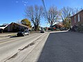
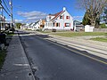 Private residences, businesses, Notre-Dame Street
 -
 Private residences, businesses, Notre-Dame Street
 -
 Cemetery, de l'Église Street


Tourbière du Lac à la Tortue Lac-à-la-Tortue Ecological Reserve [8] [9]
- The peat bog, unprotected and protected areas
-
 Private forest road
 -
 Sign, rang Saint-Félix
 -
 Protected area rang Saint-Félix


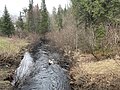
- Rivière au Lard (rivière Champlain)
-
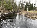
![Rang St-Félix, from bridge des Ours (01578)[10]](https://upload.wikimedia.org/wikipedia/commons/thumb/b/b4/Saint_Maurice_006.jpg/120px-Saint_Maurice_006.jpg) Rang St-Félix, from bridge des Ours (01578) [10]
Rang St-Félix, from bridge des Ours (01578) [10] -
 Rang St-Felix, from bridge des Ours (01578)
 -
![Rang St-Alexis, from bridge 01576[11]](https://upload.wikimedia.org/wikipedia/commons/thumb/2/21/Saint_Maurice_020.jpg/120px-Saint_Maurice_020.jpg) Rang St-Alexis, from bridge 01576 [11]
Rang St-Alexis, from bridge 01576 [11] -
 Private forest road
 -
![From bridge P-01574[3], rang Ste-Marguerite](https://upload.wikimedia.org/wikipedia/commons/thumb/f/f3/Saint_Maurice_028.jpg/120px-Saint_Maurice_028.jpg) From bridge P-01574, [12] rang Ste-Marguerite
From bridge P-01574, [12] rang Ste-Marguerite -
 From bridge P-01574, rang Ste-Marguerite
![Rang St-Félix, from bridge des Ours (01578)[10]](/info/en/?search=File:Saint_Maurice_006.jpg)

![Rang St-Alexis, from bridge 01576[11]](/info/en/?search=File:Saint_Maurice_020.jpg)

![From bridge P-01574[3], rang Ste-Marguerite](/info/en/?search=File:Saint_Maurice_028.jpg)

References
- ^ "Banque de noms de lieux du Québec: Reference number 57222". toponymie.gouv.qc.ca (in French). Commission de toponymie du Québec.
- ^ a b "Répertoire des municipalités: Geographic code 37230". www.mamh.gouv.qc.ca (in French). Ministère des Affaires municipales et de l'Habitation.
- ^ a b "Census Profile, 2016 Census - Saint-Maurice, Paroisse (Municipalité de) [Census subdivision], Quebec and Saint-Raymond [Population centre], Quebec". February 8, 2017.
- ^ "Population and dwelling counts: Canada, provinces and territories, and census subdivisions (municipalities), Quebec". Statistics Canada. February 9, 2022. Retrieved August 29, 2022.
- ^ Statistics Canada: 1996, 2001, 2006, 2011, 2016 census
- ^ "Home - Mauricie English Elementary School - Liferay".
- ^ "Three Rivers Academy - CQSB - Liferay".
- ^ "Tourbière du Lac à la Tortue". Commission de toponymie Quebec (in French). Government of Quebec. September 21, 2023. Retrieved October 29, 2023.
- ^ Louis-Martin Pilote, NCC (March 28, 2019). "In the depths of the Lac-Ã -la-Tortue bog". Science Borealis. Retrieved October 29, 2023.
- ^ Ministère des Transports et de la Mobilité durable Québec (May 5, 2023). "Inventaire et inspection des structures". Retrieved May 5, 2023.
- ^ Ministère des Transports et de la Mobilité durable Québec (May 5, 2023). "Inventaire et inspection des structures". Retrieved May 5, 2023.
- ^ Ministère des Transports et de la Mobilité durable Québec (May 10, 2023). "Inventaire et inspection des structures" (aspx). Retrieved May 10, 2023.
Places adjacent to Saint-Maurice, Quebec | |
|---|---|
| Municipalities | |
|---|---|
| Parishes | |
| International | |
|---|---|
| National | |
| Geographic | |