Saint-Léonard
St. Leonard | |
|---|---|
 | |
 Coat of arms | |
 Saint-Léonard Location of Saint-Léonard in New Brunswick | |
| Coordinates: 47°09′45″N 67°55′30″W / 47.1625°N 67.925°W | |
| Country | Canada |
| Province | New Brunswick |
| County | Madawaska |
| Parish | Saint-Léonard |
| Town | Vallée-des-Rivières |
| Settled | 1789 |
| Town Status | 1920 |
| Electoral Districts Federal | Madawaska—Restigouche |
| Provincial | Restigouche-La-Vallée |
| Area | |
| • Land | 5.34 km2 (2.06 sq mi) |
| Elevation | 150 to 171 m (492 to 561 ft) |
| Population (2021)
[1] | |
| • Total | 1,322 |
| • Density | 247.8/km2 (642/sq mi) |
| • Change 2016–21 | |
| Time zone | UTC-4 ( AST) |
| • Summer ( DST) | UTC-3 ( ADT) |
| Postal code(s) | |
| Area code |
|
| Dwellings | 603 |
| Median Income* | $48,512 CDN |
| NTS Map | 021O04 |
| GNBC Code | DAADY |
| Website | www.saint-leonard.ca |
| |
Saint-Léonard is a former town in Madawaska County, New Brunswick, Canada. [2] It held town status prior to 2023 and is now part of the town of Vallée-des-Rivières.
History
Saint-Léonard was once a popular town during Prohibition in the United States as it was easy to smuggle alcohol to Van Buren.
The town's economy is driven by potato farming and a J.D. Irving Limited sawmill. Saint-Léonard is officially bilingual but it is predominantly a Francophone community.
On June 30, 2008, a truck carrying 12 million bees overturned near Saint-Léonard. This accident was the first of its kind in New Brunswick. [3]
On 1 January 2023, Saint-Léonard amalgamated with the village of Sainte-Anne-de-Madawaska and parts of four local service districts to form the new town of Vallée-des-Rivières. [4] [5] The community's name remains in official use. [6]
Geography
It is located on the east bank of the Saint John River opposite Van Buren, Maine, to which it is connected via the Saint Leonard–Van Buren Bridge.
Climate
The town has a warm-summer humid continental climate ( Köppen: Dfb), even for this type of climate the warm season can be milder for a non-coastal city like Saint John, because the Great Lakes and Appalachians hold much of the heat. that come from the Gulf of Mexico and the interior of the United States. But winters are substantially cold with spring and fall with pleasant temperatures. [7]
| Climate data for Saint-Léonard ( Saint-Léonard Aerodrome), elevation: 241 m or 791 ft, 1981-2010 normals, extremes 1985-present | |||||||||||||
|---|---|---|---|---|---|---|---|---|---|---|---|---|---|
| Month | Jan | Feb | Mar | Apr | May | Jun | Jul | Aug | Sep | Oct | Nov | Dec | Year |
| Record high humidex | 12.2 | 13.0 | 16.8 | 29.1 | 33.8 | 41.3 | 42.3 | 41.9 | 38.6 | 30.6 | 21.9 | 13.4 | 42.3 |
| Record high °C (°F) | 11.7 (53.1) |
14.4 (57.9) |
17.7 (63.9) |
28.1 (82.6) |
34.6 (94.3) |
34.0 (93.2) |
34.2 (93.6) |
34.6 (94.3) |
33.4 (92.1) |
26.7 (80.1) |
18.7 (65.7) |
13.17 (55.71) |
34.6 (94.3) |
| Mean daily maximum °C (°F) | −7.1 (19.2) |
−5.5 (22.1) |
0.7 (33.3) |
8.1 (46.6) |
16.6 (61.9) |
21.6 (70.9) |
24.0 (75.2) |
23.1 (73.6) |
18.0 (64.4) |
10.3 (50.5) |
3.0 (37.4) |
−3.9 (25.0) |
9.1 (48.3) |
| Daily mean °C (°F) | −12.6 (9.3) |
−11.3 (11.7) |
−4.9 (23.2) |
2.9 (37.2) |
10.0 (50.0) |
15.1 (59.2) |
18.0 (64.4) |
16.8 (62.2) |
12.0 (53.6) |
5.4 (41.7) |
−1.2 (29.8) |
−8.6 (16.5) |
3.5 (38.2) |
| Mean daily minimum °C (°F) | −18.1 (−0.6) |
−17.0 (1.4) |
−10.4 (13.3) |
−2.5 (27.5) |
3.4 (38.1) |
8.6 (47.5) |
11.9 (53.4) |
10.4 (50.7) |
5.8 (42.4) |
0.4 (32.7) |
−5.3 (22.5) |
−13.2 (8.2) |
−2.2 (28.1) |
| Record low °C (°F) | −38.8 (−37.8) |
−33.4 (−28.1) |
−33.6 (−28.5) |
−19.3 (−2.7) |
−5.6 (21.9) |
−2.6 (27.3) |
2.7 (36.9) |
−0.2 (31.6) |
−6.3 (20.7) |
−9.6 (14.7) |
−23.2 (−9.8) |
−33.9 (−29.0) |
−38.8 (−37.8) |
| Record low wind chill | −46 | −43 | −42 | −30 | −11 | −4 | 0 | 0 | −8 | −13 | −28 | −42 | −46 |
| Average precipitation mm (inches) | 91.5 (3.60) |
67.5 (2.66) |
77.5 (3.05) |
77.1 (3.04) |
87.4 (3.44) |
98.2 (3.87) |
119.3 (4.70) |
101.4 (3.99) |
94.9 (3.74) |
100.4 (3.95) |
98.3 (3.87) |
90.5 (3.56) |
1,104 (43.47) |
| Average rainfall mm (inches) | 24.3 (0.96) |
9.4 (0.37) |
20.9 (0.82) |
50.2 (1.98) |
84.7 (3.33) |
98.2 (3.87) |
119.3 (4.70) |
101.4 (3.99) |
94.9 (3.74) |
92.4 (3.64) |
65.0 (2.56) |
31.5 (1.24) |
792.2 (31.2) |
| Average snowfall cm (inches) | 78.2 (30.8) |
64.4 (25.4) |
59.6 (23.5) |
26.0 (10.2) |
2.2 (0.9) |
0.0 (0.0) |
0.0 (0.0) |
0.0 (0.0) |
0.0 (0.0) |
6.7 (2.6) |
32.3 (12.7) |
65.5 (25.8) |
334.9 (131.9) |
| Average precipitation days (≥ 0.2 mm) | 16.1 | 12.5 | 13.0 | 13.9 | 15.0 | 14.7 | 15.9 | 13.9 | 13.2 | 15.2 | 14.8 | 15.3 | 173.5 |
| Average rainy days (≥ 0.2 mm) | 3.3 | 1.8 | 4.6 | 9.5 | 14.7 | 14.7 | 15.9 | 13.9 | 13.2 | 14.1 | 8.6 | 4.3 | 118.6 |
| Average snowy days (≥ 0.2 cm) | 15.3 | 12.1 | 10.7 | 6.3 | 0.85 | 0 | 0 | 0 | 0.04 | 2.1 | 8.4 | 13.9 | 69.69 |
| Average relative humidity (%) | 74.7 | 71.3 | 67.8 | 57.7 | 50.2 | 55.4 | 59.8 | 58.7 | 60.6 | 64.3 | 75.6 | 77.8 | 64.5 |
| Source: Environment Canada [8] | |||||||||||||
-
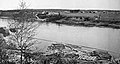 Saint-Léonard, 1918
 -
 Saint-Leonard railroad station
.jpg)

Demographics
In the 2021 Census of Population conducted by Statistics Canada, Saint-Léonard had a population of 1,322 living in 567 of its 625 total private dwellings, a change of 1.7% from its 2016 population of 1,300. With a land area of 5.34 km2 (2.06 sq mi), it had a population density of 247.6/km2 (641.2/sq mi) in 2021. [1]
|
Mother tongue language (2006) [13]
| ||||||||||||||||||||||||||||||||||||||||||||||||
Education
It has a single school, École Grande-Rivière.
Notable people
See also
References
- ^ a b c "Census Profile of Saint-Léonard, Town (TV)". Statistics Canada. 6 December 2022. Retrieved 21 January 2023.
- ^ New Brunswick Provincial Archives - Saint-Léonard
- ^ "Lorry carrying 12m bees overturns". BBC News Online. 2008-07-01. Retrieved 2008-07-01.
- ^ "Local Governments Establishment Regulation – Local Governance Act". Government of New Brunswick. 12 October 2022. Retrieved 21 January 2023.
- ^ "RSC 1 Northwest Regional Service Commission". Government of New Brunswick. Retrieved 21 January 2023.
- ^ "Proposed entity names reflect strong ties to nature and history" (Press release). Irishtown, New Brunswick: Government of New Brunswick. 25 May 2022. Retrieved 21 January 2023.
- ^ "St. Leonard, New Brunswick Köppen Climate Classification (Weatherbase)". Weatherbase. Retrieved 2019-08-08.
- ^ "Canadian Climate Normals 1981-2010 Station Data - Climate - Environment and Climate Change Canada". climate.weather.gc.ca. Environment and Climate Change Canada. 2013-09-25. Retrieved 2019-08-08.
- ^ Statistics Canada: 1996, 2001, 2006, 2011 census
- ^ [1], Census 1941-1951
- ^ Statistics Canada Population and dwelling counts, for Canada, provinces and territories, and census subdivisions (municipalities), 2011 and 2006 censuses
- ^ "Census Profile, 2016 Census: Saint-Léonard, Town". Statistics Canada. Retrieved August 13, 2019.
- ^ 2006 Statistics Canada Community Profile: Saint-Léonard, New Brunswick
External links
Places adjacent to Saint-Léonard, New Brunswick | |
|---|---|
Subdivisions of
New Brunswick | |
|---|---|
| Cities | |
| Towns |
|
| Villages | |
| Regional municipality | |
| Rural communities | |
| Rural districts |
|
| Other administrative divisions | |
| International | |
|---|---|
| National | |