Saint-Donat Airfield | |
|---|---|
| Part of Twelfth Air Force | |
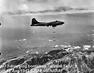
 301st Bombardment Group B-17F attacking Tervi, Italy, on 11 August 1943. | |
| Coordinates | 36°06′38.66″N 005°59′19.72″E / 36.1107389°N 5.9888111°E |
| Type | Military airfield |
| Site information | |
| Controlled by | United States Army Air Forces |
| Site history | |
| Built | 1942 |
| In use | 1942-1943 |
Location of Saint-Donat Airfield, Algeria
Saint-Donat Airfield was a World War II military airfield in Algeria, located near Tadjenanet in Mila Province; approximately 63 km southwest of Constantine. It was used by the United States Army Air Force Twelfth Air Force as a heavy bomber ( B-17 Flying Fortress) airfield during the North African Campaign. Known units assigned to the field were:
- 301st Bombardment Group, 6 March-6 August 1943, B-17 Flying Fortress
Due to the limited amount of aerial photography available, it is not possible to precisely determine the location and condition of the airfield today.
See also
References
![]() This article incorporates
public domain material from the
Air Force Historical Research Agency
This article incorporates
public domain material from the
Air Force Historical Research Agency
- Maurer, Maurer. Air Force Combat Units of World War II. Maxwell AFB, Alabama: Office of Air Force History, 1983. ISBN 0-89201-092-4.
- Maurer, Maurer, ed. (1982) [1969]. Combat Squadrons of the Air Force, World War II (PDF) (reprint ed.). Washington, DC: Office of Air Force History. ISBN 0-405-12194-6. LCCN 70605402. OCLC 72556.
- USAFHRA search for Saint-Donat Airfield
External links
