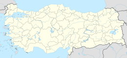
Native name: Sıçan Adası | |
|---|---|
| Geography | |
| Location | Mediterranean Sea |
| Coordinates | 36°48′09″N 30°35′20″E / 36.80250°N 30.58889°E |
| Administration | |
| İl (province) | Antalya Province |
Sıçan Island ( Turkish: Sıçan Adası) is an islet in the Gulf of Antalya. In the history the islet had a number of names. According to Prof. Mustafa Adak, the oldest name of the islet was Lyrnateia. During the Roman Empire era it was called Attelebussa (grasshopper) . Italian seamen of the Medieval Ages used the name Renathia. Evliya Çelebi the famous Ottoman Empire traveler of the 17th century called the island Güvercin (dove) and Kuş (bird). In the 19th century its name was Rasat (observation) [1]
The islet faces a small fishing port to the west of Antalya at 36°48′09″N 30°35′22″E / 36.80250°N 30.58944°E. Its distance to the mainland ( Anatolia) to north west is less than 100 metres (330 ft). Its surface area is about 0.04 kilometres (0.025 mi).There is a ramp from west to east of the islet and the east side is a high cliff. [1] The uninhabited islet is attractive for the divers. The maximum depth in the sandy west coast is 8 metres (26 ft). But the depth in the east coast is 22 metres (72 ft). [2] There is also an underwater cave in the east.
