PhotosLocation


Roskow Latitude and Longitude:

52°28′00″N 12°43′59″E / 52.46667°N 12.73306°E / 52.46667; 12.73306
From Wikipedia, the free encyclopedia
Roskow
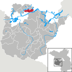
Location of Roskow within Potsdam-Mittelmark district
Bad Belzig Beelitz Beetzsee Beetzseeheide Bensdorf Borkheide Borkwalde Brück Buckautal Golzow Görzke Gräben Havelsee Kleinmachnow Kloster Lehnin Linthe Linthe Michendorf Mühlenfließ Niemegk Nuthetal Päwesin Planebruch Planetal Rabenstein Rosenau Roskow Schwielowsee Seddiner See Stahnsdorf Teltow Treuenbrietzen Wenzlow Werder (Havel) Wiesenburg Wollin Wusterwitz Ziesar Groß Kreutz Brandenburg
Roskow is located in Germany
Roskow
Roskow
Roskow is located in Brandenburg
Roskow
Roskow
Coordinates: 52°28′00″N 12°43′59″E / 52.46667°N 12.73306°E / 52.46667; 12.73306
Country Germany
State Brandenburg
District Potsdam-Mittelmark
Municipal assoc. Beetzsee
Subdivisions3 Ortsteile
Government
 •  Mayor (2019–24) Thomas Schulz [1]
Area
 • Total38.78 km2 (14.97 sq mi)
Elevation
27 m (89 ft)
Population
 (2022-12-31) [2]
 • Total1,186
 • Density31/km2 (79/sq mi)
Time zone UTC+01:00 ( CET)
 • Summer ( DST) UTC+02:00 ( CEST)
Postal codes
14778
Dialling codes033831
Vehicle registrationPM

Roskow is a municipality in the Potsdam-Mittelmark district, in Brandenburg, Germany.

Demography
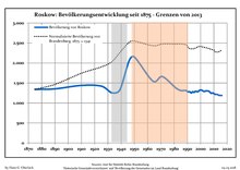
Development of population since 1875 within the current Boundaries (Blue Line: Population; Dotted Line: Comparison to Population development in Brandenburg state; Grey Background: Time of Nazi Germany; Red Background: Time of communist East Germany)
Roskow: Population development
within the current boundaries (2013) [3]
Year Pop. ±% p.a.
1875 1,341—    
1890 1,354+0.06%
1910 1,440+0.31%
1925 1,422−0.08%
1933 1,256−1.54%
1939 1,327+0.92%
1946 2,056+6.45%
1950 2,150+1.12%
1964 1,547−2.32%
1971 1,663+1.04%
1981 1,385−1.81%
1985 1,312−1.34%
1989 1,314+0.04%
1990 1,282−2.44%
1991 1,281−0.08%
1992 1,278−0.23%
1993 1,250−2.19%
1994 1,283+2.64%
1995 1,265−1.40%
1996 1,293+2.21%
Year Pop. ±% p.a.
1997 1,286−0.54%
1998 1,282−0.31%
1999 1,313+2.42%
2000 1,325+0.91%
2001 1,318−0.53%
2002 1,297−1.59%
2003 1,289−0.62%
2004 1,304+1.16%
2005 1,302−0.15%
2006 1,298−0.31%
2007 1,274−1.85%
2008 1,243−2.43%
2009 1,253+0.80%
2010 1,233−1.60%
2011 1,215−1.46%
2012 1,217+0.16%
2013 1,208−0.74%
2014 1,191−1.41%
2015 1,189−0.17%
2016 1,188−0.08%

References

  1. ^ Landkreis Potsdam-Mittelmark Wahl der Bürgermeisterin / des Bürgermeisters, accessed 2 July 2021.
  2. ^ "Bevölkerungsentwicklung und Bevölkerungsstandim Land Brandenburg Dezember 2022" (PDF). Amt für Statistik Berlin-Brandenburg (in German). June 2023.
  3. ^ Detailed data sources are to be found in the Wikimedia Commons. Population Projection Brandenburg at Wikimedia Commons