| Rosetta Head South Australia | |
|---|---|
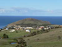
 Rosetta Head, west side | |
 Rosetta Head | |
| Coordinates | 35°35′29″S 138°36′14″E / 35.59139°S 138.60389°E |
| Postcode(s) | 5211 |
| Elevation | 97 m (318 ft) [1] |
| LGA(s) | City of Victor Harbor |
Rosetta Head, known as Kongkengguwar by the Ramindjeri people but more commonly known as The Bluff, is a headland located on the south coast of Fleurieu Peninsula in Encounter Bay, South Australia, within the local government area of the City of Victor Harbor. It is a prominent landmark on the coast, about 77 kilometres (48 miles) south of the state capital of Adelaide, and currently used as a recreational reserve.
Description
Rosetta Head is located in the suburb of Encounter Bay about 3.9 kilometres (2.4 miles) south-west by south of the centre of Victor Harbor and about 77 kilometres (48 miles) south of Adelaide. [2] When viewed from a platform such as a ship, it appears as being "a grassy mound, 97 metres (318 feet) high, cliffy on its E[ast] side, and covered with granite boulders; it is steep-to on its E[ast] and S[outh] sides." [3] Its southern tip is considered by Australian authorities as being the western extent of Encounter Bay. [4] On its northern side, there is a small wharf which is connected to the adjoining urban area by a road and which adjoins a body of water is known as Rosetta Harbor. On its southern side, there is a small cove called Petrel Cove. [1]
Formation, geology and oceanography
Rosetta Head as a headland was formed when the sea reached its present level 7,500 years ago after sea levels started to rise at the start of the Holocene. As a landform, it is a large domed inselberg which is considered to be "the most prominent feature along Encounter Bay coastline" and whose form is due to its origins via the geological processes of metamorphism and intrusion followed by two phases of erosion; firstly via the action of a northward-moving glacier during the Permian which created the distinctive dome shape and then by wave action from the south due to the sea level rise during the Holocene. When viewed from the adjoining coastline, it is considered to be a typical example of a glacial terrain known as a roche moutonnee. [5] [6] [7] [8] Geologically, Rosetta Head is the result of the intrusion of molten granite (known as Encounter Bay Granite) into a grey metamorphic rock (known as the Kanmantoo group), which was subsequently elevated as part of a mountain-building event known as the Delamerian Orogeny between 475 and 500 million years ago. [7] The water adjoining the base of Rosetta Head drops to a maximum depth of 12.8 metres (42 feet) within a distance of 100 metres (330 feet) of its shore. [1]
History
Aboriginal occupation
Although traditional ownership of Encounter Bay has long been ascribed to the Ramindjeri clan of the Ngarrindjeri people, [9] linguist Rob Amery of the University of Adelaide suggested in a 1998 paper that Kaurna traditional lands "may have extended as far eastward as Encounter Bay and that the occupation of Encounter Bay by the Ramindjeri in the late 1830s may have been a response to the activities of whalers in the area". He also notes that the "Encounter Bay people" mentioned in 1836 by Colonel Light and his party at Rapid Bay in 1836 spoke the Kaurna language. [10]
European discovery and use
Rosetta Head was the site of a whaling station, with its peak used as a look-out point to locate whales. The station was established in 1837 and operated until the early 1860s. [11] [12] [13] The wharf, an adjacent sea wall and the connecting road were completed in 1856 by the SA Government to assist whaling industry activity. The wharf was known as the "Lilliputian Jetty" due to its relatively small size, i.e. 12.7 metres (42 feet) wide by 4.6 metres (15 feet) deep. [14] A mine was established on Rosetta Head in 1863 to search for copper and other minerals until the abandonment of the venture in 1866. [15] A tablet set into a granite boulder located near Rosetta Head's summit was unveiled on 8 April 1902 by the Governor of South Australia, The Right Honourable Hallam, Baron Tennyson, KCMG to commemorate the centenary of the meeting of the European explorers, Matthew Flinders and Nicolas Baudin, in nearby waters. [16]
Naming
The Ramindjeri language name for Encounter Bay was Ramong, [17] [18] although some sources ascribe this name to The Bluff only. [19] The name Kongkengguwar is however more commonly ascribed to The Bluff. [20] [21] [22] [23]
Rosetta Head was given its modern name in 1839 after Rosetta French, the wife of George Fife Angas reportedly by George Gawler, the second Governor of South Australia. [11] [24] The use of the name "The Bluff" which is the most commonly used name for the headland is attributed to whalers operating in the locality prior to the adoption of the name Rosetta Head. [25] [26]
Heritage listings
Rosetta Head was listed on the now-defunct Register of the National Estate on 21 October 1980. [27] It was listed on the South Australian Heritage Register on 1 September 1983. [28]
Current land use
Rosetta Head is used as a public recreation reserve which is managed by the City of Victor Harbor. A walking trail ascends to the summit where views of the adjoining coastline including the Victor Harbor urban area and the nearby islands are available as well as the opportunity to observe southern right whales in the nearby waters between the months of May and November. As of 2007, a proposal existed to connect the Rosetta Head walking trail to the Heysen Trail to its west via a trail following the coastline. [15] [29] [30] A sandy beach on the north side of Rosetta Head is notable as a site for swimming while the wharf is used for recreational fishing. A sandy beach on the south side of the head at Petrel Cove is known for its surfing and surf fishing but is considered to be a hazardous location for swimming. The sea around Rosetta Head is a popular site for recreational diving and is notable as a place to see Leafy sea dragons. [31] [32] [33]
Gallery
-
 Painting of Encounter Bay by George French Angas circa 1846 depicting Rosetta Head from the east.
 -
 Plaque unveiled on 8 April 1902 to commemorate the meeting of Matthew Flinders and Nicolas Baudin in 1802.
 -
 View of Victor Harbor from Rosetta Head.
 -
 View of coastline west of Rosetta Head.
 -
 View of Rosetta Head from the north.
.jpg)
.jpg)


References
- ^ a b c South Australia. Department of Marine and Harbors (1985), The Waters of South Australia a series of charts, sailing notes and coastal photographs, Dept. of Marine and Harbors, South Australia, pp. Charts 10, ISBN 978-0-7243-7603-2
- ^ "Suburbs Map - District" (PDF). City of Victor Harbor. Retrieved 31 July 2015.
- ^ Sailing Directions (Enroute), Pub. 175: North, West, and South Coasts of Australia (PDF). Sailing Directions. United States National Geospatial-Intelligence Agency. 2017. p. 227.
- ^ "Seas and Submerged Lands (Historic Bays) Proclamation 2006". Commonwealth of Australia. Retrieved 29 July 2014.
- ^ Robinson, A. C.; Armstrong, D. M., eds. (1999). A Biological Survey of Kangaroo Island, South Australia, 1989 & 1990 (PDF). Adelaide, SA: Heritage and Biodiversity Section, Department for Environment, Heritage and Aboriginal Affairs, South Australia. p. 26. ISBN 0-7308-5862-6. Retrieved 1 May 2014.
- ^ "Rosetta Head, Franklin Pde, Encounter Bay, SA, Australia (Register of the National Estate (Non-statutory archive))". Department of the Environment. 21 October 1980. Retrieved 29 June 2014.
- ^
a
b Noel Hiern, Field Guide Subcommittee, Geological Society of Australia (South Australian Division) (2012).
"Geological trail VICTOR HARBOR, A self-drive geological trail" (PDF). Government of South Australia, Department for Manufacturing, Innovation, Trade, Resources and Energy. pp. 2–3. Archived from
the original (PDF) on 11 April 2013. Retrieved 15 August 2014.
{{
cite web}}
: CS1 maint: multiple names: authors list ( link) - ^ "Geological Sites, The Bluff". City of Victor Harbor. Retrieved 16 August 2014.
- ^ "Map of Indigenous Australia". AIATSIS. Retrieved 17 November 2020.
- ^ Amery, Rob (2016). Warraparna Kaurna!: Reclaiming an Australian language (PDF). University of Adelaide Press. p. 5. doi: 10.20851/kaurna. ISBN 978-1-925261-25-7. Retrieved 17 November 2020.
- ^ a b Webb, Lucy (10 October 1936). "Historic Victor Harbor". The Mail. p. 10. Retrieved 29 June 2014.
- ^ "South Australian Company". South Australian Gazette and Colonial Register. 3 June 1837. p. 4. Retrieved 16 August 2014.
- ^ "The Romantic South, some early history, part III". The Register. 15 September 1928. p. 5. Retrieved 16 August 2014.
- ^ Collins, Neville C (2005), The jetties of South Australia : past and present, Neville Collins, p. 192, ISBN 978-0-9580482-2-4
- ^ a b "The Bluff Summit Walk" (PDF). City of Victor Harbor. Archived (PDF) from the original on 5 May 2005. Retrieved 29 June 2014.
- ^ "The meeting of Flinders and Baudin, Commemorated at the Bluff, An interesting event". The Register. 9 April 1902. p. 6. Retrieved 24 July 2014.
- ^ "Ramindjeri". Mobile Language Team. 17 November 2020. Retrieved 17 November 2020.
- ^ "Ramindjeri (SA)". South Australian Museum. Retrieved 17 November 2020.
- ^ "Encounter Bay (1840-1848)". German Missionaries in Australia. Griffith University. Retrieved 17 November 2020.
- ^ "Places". Great Southern Reef. Retrieved 17 November 2020.
- ^ Victor Harbor Council (20 June 2017). "Development Plan". Government of South Australia.
- ^ "The Romantic South, some early history, part IV". The Register. 22 September 1928. p. 5. Retrieved 16 August 2014.
- ^ "Kongkengguwar". Gazetteer of Australia online. Geoscience Australia, Australian Government.
- ^ "Commemoration Address". The Register. 15 April 1927. p. 8. Retrieved 16 August 2014.
- ^ Newland, Simpson (2 December 1893). "Paving the way, A romance of the Australian bush, Part 1 - On the coast". South Australian Chronicle. p. 10. Retrieved 15 August 2014.
- ^ "'Paving the way', The romance of Victor Harbor". The Register. 19 September 1924. p. 11. Retrieved 16 August 2014.
- ^ "Rosetta Head, Franklin Pde, Encounter Bay, SA, Australia - listing on the now-defunct Register of the National Estate (Place ID 7472)". Australian Heritage Database. Australian Government. 21 October 1980. Retrieved 27 January 2019.
-
^
"The Bluff Historic Site". Government of South Australia. 1 September 1983. Retrieved 11 January 2019.
Quote - "The Bluff (Rosetta Head) Historic Site, including the Jetty & Whaling Station Site"
- ^ "City of Victor Harbor Reserves" (PDF). City of Victor Harbor. Retrieved 14 August 2014.
- ^ City of Victor Harbor Recreation and Open Space Study: Recreation and Open Space Strategic Directions Report Volume 2 – FINAL DRAFT (PDF). Suter Planners. February 2007. p. 51.
- ^ "Petrel Cove, unpatrolled beach". Surf Life Saving Australia. Retrieved 16 August 2014.
- ^ "Rosetta Head, unpatrolled beach". Surf Life Saving Australia. Retrieved 14 August 2014.
- ^ Neville Coleman; Nigel Marsh. "Victor Harbour (sic)". Underwater Australia. Neville Coleman. Archived from the original on 2 February 2013. Retrieved 14 August 2014.