| Robinson Peak | |
|---|---|
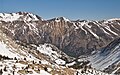
 South aspect | |
| Highest point | |
| Elevation | 10,793 ft (3,290 m) [1] |
| Prominence | 393 ft (120 m) [1] |
| Parent peak | Eagle Peak (11,847 ft) [2] |
| Isolation | 1.55 mi (2.49 km) [2] |
| Coordinates | 38°09′57″N 119°23′11″W / 38.1659487°N 119.3864829°W [3] |
| Naming | |
| Etymology | Moses Robinson [4] |
| Geography | |
 Robinson Peak Location in California  Robinson Peak Robinson Peak (the United States) | |
| Location | Mono County, California, U.S. |
| Parent range | Sierra Nevada |
| Topo map | USGS Buckeye Ridge |
| Geology | |
| Mountain type | Fault block |
| Climbing | |
| Easiest route | class 2 [2] North slope |
Robinson Peak is a mountain with an elevation of 10,793 feet (3,290 m) located in the Sierra Nevada mountain range, in Mono County of northern California, United States. [3] The summit is situated on the boundary of Hoover Wilderness, on land managed by Humboldt–Toiyabe National Forest. The peak is set above the west end of Twin Lakes, two miles east of Victoria Peak, and 1.5 mile southeast of line parent Eagle Peak. Precipitation runoff from this mountain drains into tributaries of Robinson and Buckeye Creeks, which are within the Walker River drainage basin. Topographic relief is significant as the summit rises approximately 3,700 feet (1,100 meters) above Robinson Creek in 1.5 mile.
History
The peak is named in association with Robinson Creek, which in turn is named for Moses Robinson, an early pioneer who operated a sawmill there in the 1860s. [5] The toponym has been officially adopted by the United States Board on Geographic Names. [3]
The first ascent of the summit was likely made by the 1905–09 USGS survey team of George Davis, A. H. Sylvester, and Pearson Chapman, but the first documented ascent was made August 22, 1946, by K. Hargreaves, H. F. Watty, R. F. Dickey, Jr., and Ken Crowley. [6]
Climate
According to the Köppen climate classification system, Robinson Peak is located in an alpine climate zone. [7] Most weather fronts originate in the Pacific Ocean, and travel east toward the Sierra Nevada mountains. As fronts approach, they are forced upward by the peaks ( orographic lift), causing moisture in the form of rain or snowfall to drop onto the range.
See also
Gallery
-
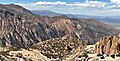
 Robinson Peak (centered), Eagle Peak in upper left.
 -
 South aspect
 -
 Eagle Peak centered in the distance with Robinson Peak to the right.
 -
 View from The Incredible Hulk with Eagle Peak in upper left corner, Robinson Peak centered, and Sawmill Ridge to right of Robinson.

.jpg)


References
- ^ a b "Robinson Peak, California". Peakbagger.com. Retrieved 2022-06-16.
- ^ a b c "Robinson Peak - 10,793' CA". listsofjohn.com. Retrieved 2022-06-15.
- ^ a b c "Robinson Peak". Geographic Names Information System. United States Geological Survey, United States Department of the Interior. Retrieved 2022-06-15.
- ^ Peter Browning, 1986, Place Names of the Sierra Nevada: From Abbot to Zumwalt, ISBN 0-89997-119-9, p. 185.
- ^ Erwin G. Gudde (2010), California Place Names: The Origin and Etymology of Current Geographical Names, University of California Press, ISBN 9780520266193, p, 319.
- ^ Swift, Robert L.; Nelson, David A. (1954). "A Climber's Guide to the High Sierra".
- ^ "Climate of the Sierra Nevada". Encyclopædia Britannica.
External links
- Weather forecast: Robinson Peak
Places adjacent to Robinson Peak (California) | ||||||||||||||||
|---|---|---|---|---|---|---|---|---|---|---|---|---|---|---|---|---|
| ||||||||||||||||