Robbins, Virginia | |
|---|---|
Ghost town | |
 Robbins  Robbins | |
| Coordinates: 36°48′13″N 82°57′45″W / 36.80361°N 82.96250°W | |
| Country | United States |
| State | Virginia |
| County | Lee |
| Elevation | 1,781 ft (543 m) |
| Time zone | UTC-5 ( Eastern (EST)) |
| • Summer ( DST) | UTC-4 (EDT) |
| GNIS feature ID | 1496563 [1] |
Robbins is a ghost town in Lee County, Virginia, United States.
The community has the name of Charles Robbins, a pioneer settler. [2]
References
- ^ U.S. Geological Survey Geographic Names Information System: Robbins, Virginia
- ^ Tennis, Joe (2004). Southwest Virginia Crossroads: An Almanac of Place Names and Places to See. The Overmountain Press. p. 18. ISBN 978-1-57072-256-1.
Municipalities and communities of
Lee County, Virginia, United States | ||
|---|---|---|
| Towns | 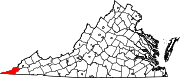 | |
| CDPs | ||
|
Unincorporated communities |
| |
| Ghost town | ||
|
| This Lee County, Virginia state location article is a stub. You can help Wikipedia by expanding it. |