| Rink Glacier | |
|---|---|
| Kangilliup Sermia Rink Isbræ | |
 Photograph of Rink Glacier | |
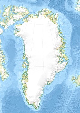
| Location | Avannaata, Greenland |
| Coordinates | 71°45′N 051°40′W / 71.750°N 51.667°W |
| Terminus |
Karrat Fjord,
Baffin Bay, North Atlantic Ocean |
Rink Glacier ( Danish: Rink Isbræ; Greenlandic: Kangilliup Sermia) is a glacier in Avannaata, Greenland.
This glacier is named in honor of Hinrich Johannes Rink, Danish geologist and Greenlandic researcher.
Geography
The Rink Glacier is the largest glacier on the west coast of Greenland. Its terminus is in the Karrat Fjord, Nordost Bay, Baffin Bay, North Atlantic Ocean. [1]
It drains an area of 30,182 km2 (11,653 sq mi) of the Greenland Ice Sheet with a flux (quantity of ice moved from the land to the sea) of 12.1 km3 (2.9 cu mi) per year, as measured for 1996. [2] As reported by Anker Weidick and Ole Bennike in 2007, it is ranked second or third in iceberg production in western Greenland. [3] It is also the swiftest moving and highest surface ice in the world. [4]
See also
References
- ^ "Rink Isbræ". Mapcarta. Retrieved 10 February 2017.
- ^ Rignot E., Kanagaratnam P. (2006). "Changes in the velocity structure of the Greenland Ice Sheet". Science. 311 (5763): 986–990. Bibcode: 2006Sci...311..986R. doi: 10.1126/science.1121381. PMID 16484490. S2CID 22389368.
- ^ "Rink Glacier, NW Greenland". osu.edu. February 6, 2009. Archived from the original on 7 July 2010. Retrieved 18 July 2010.
- ^ "Popular Science". Popular Science. 123 (6). Bonnier Corporation: 25. Dec 1933. ISSN 0161-7370.
