Rijsenhout | |
|---|---|
Village | |
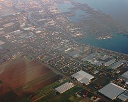
 Aerial photo with a view of Rijsenhout and the Westeinderplassen | |
 | |
 The town centre (darkgreen) and the statistical district (lightgreen) of Rijsenhout in the municipality of Haarlemmermeer. | |
| Coordinates: 52°16′N 4°42′E / 52.267°N 4.700°E | |
| Country | Netherlands |
| Province | North Holland |
| Municipality | Haarlemmermeer |
| Population (January
2008
[1]) | |
| • Total | 4,103 |
| Time zone | UTC+1 ( CET) |
| • Summer ( DST) | UTC+2 ( CEST) |
Rijsenhout is a village in the Dutch province of North Holland. It is a part of the municipality of Haarlemmermeer, and lies about 6 km southeast of Hoofddorp. In 2001, the village of Rijsenhout had 3072 inhabitants. The built-up area of the town was 0.63 km², and contained 1237 residences. [2] The wider statistical area of Rijsenhout has a population of around 4540. [3]
References
- ^ Aantal inwoners per woonkern Archived 2006-12-12 at the Wayback Machine. Ons-Haarlemmermeer.nl, 5 november 2008
- ^ Statistics Netherlands (CBS), Bevolkingskernen in Nederland 2001 "CBS - Bevolkingskernen in Nederland 2001". Archived from the original on March 19, 2006. Retrieved January 24, 2007.. Statistics are for the continuous built-up area.
- ^ Statistics Netherlands (CBS), Gemeente Op Maat 2004: Haarlemmermeer [1][ permanent dead link].
