Rhodesdale, Maryland | |
|---|---|
 Rhodesdale | |
| Coordinates: 38°34′34″N 75°50′10″W / 38.57611°N 75.83611°W | |
| Country | |
| State | |
| County | |
| Elevation | 12 m (39 ft) |
| Time zone | UTC-5 ( Eastern (EST)) |
| • Summer ( DST) | UTC-4 (EDT) |
| ZIP code | 21659 |
| Area code(s) | 410, 443, and 667 |
| GNIS feature ID | 586815 [1] |
Rhodesdale is an unincorporated community in Dorchester County, Maryland, United States. [1] Rhodesdale is located at the intersection of Maryland routes 14 and 331, north of Vienna and west of Brookview.
References
Municipalities and communities of
Dorchester County, Maryland, United States | ||
|---|---|---|
| City | 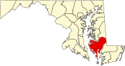 | |
| Towns | ||
| CDPs | ||
|
Other communities | ||
| Footnotes | ‡This populated place also has portions in an adjacent county or counties | |