Relizane Province
ولاية غليزان | |
|---|---|
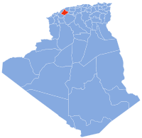
 Map of Algeria highlighting Relizane | |
| Coordinates: 35°44′N 0°33′E / 35.733°N 0.550°E | |
| Country | |
| Capital | Relizane |
| Government | |
| • PPA president | Mr. Benaouda Bettayeb ( RND) |
| • Wāli | Mr. Boukarabila Djelloul |
| Area | |
| • Total | 4,870 km2 (1,880 sq mi) |
| Population (2008)
[1] | |
| • Total | 733,060 |
| • Density | 150/km2 (390/sq mi) |
| Time zone | UTC+01 ( CET) |
| Area Code | +213 (0) 46 |
| ISO 3166 code | DZ-48 |
| Districts | 13 |
| Municipalities | 38 |

Relizane ( Arabic: ولاية غليزان) is a province ( wilaya) of Algeria. Relizane is the capital. Other localities include Bendaoud, Bouzegza, Hamri, Kalaa, Mazouna and Zemmoura. The Wilaya of Relizane massacres of 4 January 1998 happened in Relizane.
History
The province was created from Mostaganem Province in 1984.
Administrative divisions
The province is divided into 13 districts ( daïras), which are further divided into 38 communes or municipalities.
Districts (daïras)
Communes
- Aïn Rahma
- Ain Tarik
- Ammi Moussa
- Belassel Bouzegza
- Bendaoud
- Beni Dergoun
- Beni Zentis
- Dar Ben Abdellah
- Djidioua
- El Guettar
- El H'Madna
- El Hamri
- El Hassi
- El Matmar
- El Ouldja
- Had Echkalla
- Kalaa
- Lahlef
- Mazouna
- Mediouna
- Mendes
- Merdja Sidi Abed
- Ouarizane
- Oued Essalem
- Oued Rhiou
- Ouled Aiche
- Ouled El Djemaa
- Ouled Sidi Mihoub
- Ramka
- Relizane
- Sidi Khettab
- Sidi Lazreg
- Sidi M'Hamed Ben Ali
- Sidi M'Hamed Benaouda
- Sidi Saada
- Souk El Had
- Yellel
- Zemmoura
References
Wikimedia Commons has media related to
Relizane Province.
- ^ Office National des Statistiques, Recensement General de la Population et de l’Habitat 2008 Archived 2008-07-24 at the Wayback Machine Preliminary results of the 2008 population census. Accessed on 2008-07-02.

