Ravensdale
Gleann na bhFiach | |
|---|---|
Townland | |

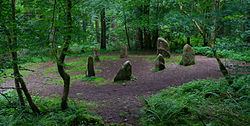
Standing stones in Ravensdale Forest | |
| Coordinates: 54°03′08″N 6°20′23″W / 54.0522°N 6.3397°W | |
| Country | Ireland |
| Province | Leinster |
| County | County Louth |
| Government | |
| • Dáil Éireann | Louth |
| Time zone | UTC+0 ( WET) |
| • Summer ( DST) | UTC-1 ( IST ( WEST)) |
| Area code(s) | 042, +353 42 |
| Irish grid reference | J088131 |

Ravensdale ( Irish: Gleann na bhFiach) [1] is a village, townland and electoral division [2] located at the foothills of the Cooley Mountains on the Cooley Peninsula in the north of County Louth in Ireland. Bordering with the townland of Doolargy ( Irish: An Dúleargaidh), Ravensdale is approximately 8 km to the north of Dundalk. The dual carriageway between Dublin and Belfast runs nearby, and the R174 connects it with Jenkinstown.
A number of public buildings in Ravensdale village, including a now-disused courthouse, former school and Saint Mary's Roman Catholic Church, were originally built in the mid-19th century. [3] [4] [5]
Ravensdale is part of the ecclesiastical parish of Ballymacscanlon and Lordship; however, the northern part of Ravensdale is part of the parish area of Jonesborough and Dromintee.[ citation needed]
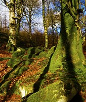
Ravensdale, which is situated beside Bellurgan, contains a number of wooded areas.[ citation needed] The Ravensdale Forest nature trail is located in the wooded demesne of the former seat of the Barons Clermont, which straddles the border between County Armagh in Northern Ireland and County Louth in the Republic of Ireland. Ravensdale Park, also known as Ravensdale Castle, the 19th-century country house itself, was one of a number of such country houses destroyed during the Irish revolutionary period. Burned in 1921, [6] the stonework of the house was later dismantled and reused during the construction of Church of St. Brigid, Glassdrummond in 1927.
The Flurry River, which flows through the area before entering Dundalk Bay at Bellurgan, was in past times a trout and salmon fishery.[ citation needed]
References
- ^ "Gleann na bhFiach / Ravensdale". logainm.ie. Placenames Database of Ireland. Retrieved 18 January 2024.
- ^ "Ravensdale Electoral Division, Co. Louth". townlands.ie. Retrieved 18 January 2024.
- ^ "Ravensdale Courthouse, Doolargy, Ravensdale, Louth". buildingsofireland.ie. National Inventory of Architectural Heritage. Retrieved 18 January 2024.
- ^ "Ravensdale School, Doolargy, Ravensdale, Louth". buildingsofireland.ie. National Inventory of Architectural Heritage. Retrieved 18 January 2024.
-
^
"Saint Mary's Roman Catholic Church, Doolargy, Louth". buildingsofireland.ie. National Inventory of Architectural Heritage. Retrieved 18 January 2024.
built c. 1840 [..] Saint Mary's Roman Catholic church is a modest structure located on the outskirts of Ravensdale
- ^ "1840 – Ravensdale Park, Dundalk, Co. Louth". archiseek.com. 17 August 2015. Retrieved 18 January 2024.
