 Rapenburgwal looking towards the
Montelbaanstoren | |
 | |
| Location | Amsterdam |
|---|---|
| Postal code | 1011 |
| Coordinates | 52°22′17″N 4°54′26″E / 52.371520°N 4.907275°E |
| Southeast end | Uilenburgergracht |
| To | Oudeschans |
The Rapenburgwal (Dutch pronunciation: [ˈraːpə(m)ˌbʏr(ə)xʋɑl]) is a secondary canal in Amsterdam in the east of the Amsterdam-Centrum district, in the Lastage neighborhood.
Location
The canal forms the northeast border of the island of Uilenburg. It is connected to Oudeschans and Uilenburgergracht, which delimit the northwest and the southeast of the island. It is crossed in its center section by Bridge 281, Peperbrug, which connects Nieuwe Uilenburgerstraat on Uilenburg island to Peperstraat on Marken (Valkenburg) island.
A 1737 map shows that the canal once ran further east to the Markengracht, which was back-filled in 1968 during construction of the IJtunnel.
-
 Detail of 1737 map, looking south. In the center a square of canals with Uilenburgergracht running across it. Clockwise from left, Markengracht (SE), Houtkopersburgwal (SW), Monkelbaansburgwal ( Oudeschans) (NW), Rapenburgwal (NE).
 -
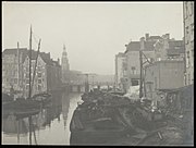 The Rapenburgwal towards Oudeschans with the Montelbaan tower. Foreground Peperbrug (bridge 281). (1900)
 -
 Rapenburgwal from the bridge at the Montelbaanstoren
 -
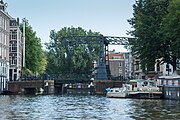 Peperbrug from Rapenwal (2016)
_Markengracht.jpg)


See also
Wikimedia Commons has media related to
Rapenburgwal.
Notes
Excludes
former canals that have since been filled in | ||
| Amstel sections | .jpg) | |
| Inner City | ||
| Lastage | ||
| Grachtengordel | ||
| Jordaan | ||
| Plantage | ||
| Westelijke Eilanden | ||
| Oostelijke Eilanden | ||