| Ramkot Fort | |
|---|---|
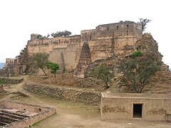
 View of Ramkot Fort | |
|
| |
| General information | |
| Location | Dadyal, Mirpur district, Azad Jammu and Kashmir |
| Construction started | 16th century AD |
Ramkot Fort ( Urdu: قلعہ رام کوٹ, romanized: Qila Ram Kot) is a medieval fort in Mirpur, Azad Kashmir. [1] [2] The fort is accessible via three routes from Dina, Dadayal, and Mirpur, with 440 stairs leading to the main gate, which is built on a sloped rock for defensive purposes. [3]
History
The fort was constructed in 1186 during the Ghurid dynasty by Sultan Ghiyas-ud-din, according to the information board at the entrance but that fort is no longer in existence.". [3] In the late 14th century, the fort was under control of Jasrat, a Punjabi Khokhar chieftain. At this fort Khokhars clashed with the armies of amir Timur in 1398. [4] However, the current structure probably dates to the 16th century builted by Kashmir Sultanate. [5] [6]
A temple with a large red Shivalinga, brought from the Ganges River, suggests a significant Hindu population once resided in the area. [3] The presence of Hindu mythological figure Ram Chandra's birthplace in nearby Pharwala may explain the fort's name. [3] However, British geologist and historian Frederick Drew attributes the fort's construction to a Gakhar named Taghlu, contradicting the information board. [3] The fort underwent renovation during the reign of Gakhar Queen Mango, whose daughter married Aurangzeb Alamgir's son. [3] During the Sikh era, the fort was handed over to the Dogras. [3]
Ramkot Fort held strategic importance, as one of the four ancient routes to Srinagar passed through it. [3] The nearby Mangla Fort, attributed to Queen Mangla, daughter of King Porus, is closely associated with the famous battle between Raja Porus and Alexander the Great in 326 BC. [3] The area is also significant for being the birthplace of Ram Chandra in 1500 BC and, much later, Mian Muhammad Bakhsh, author of Saif-ul-Malook. [3]
Architecture
The main gate, constructed with red bricks, contrasts with the stone used elsewhere, suggesting possible destruction and reconstruction. [3] A smaller gate at the back was likely used for escape. [3]
The fort's interior features two large ponds for rainwater collection, essential due to its elevation and previous location at the confluence of the Jhelum and Poonch rivers. [3] Collapsed rooms, raw iron deposits, and the superintendent's residence are found within the complex. [3] The fort also includes a slope for hauling cannons, with a donated cannon on the rampart. [3]
Gallery
-
 Landscape view
 -
 Bird's eye view
 -
 Courtyard


See also
- List of UNESCO World Heritage Sites in Pakistan
- List of forts in Pakistan
- List of museums in Pakistan
References
- ^ "Fort forlorn and forsaken | Footloose". The News International.
- ^ "Ramkot Fort: Centuries-old Kashmiri heritage site on the verge of destruction". The Express Tribune. January 29, 2012.
- ^ a b c d e f g h i j k l m n o "منگلا ڈیم کے قریب رامائن کے رام چندر سے منسوب قلعہ" [Fort attributed to Ram Chander of Ramayana near Mangla Dam]. Independent Urdu. February 19, 2021.
- ^ Panikkar, Ayyappa (1997). Medieval Indian Literature: Surveys and selections. Sahitya Akademi. p. 72. ISBN 978-81-260-0365-5.
- ^ Ali, Aown (July 3, 2015). "Ramkot Fort: The crumbling giant of Azad Kashmir". DAWN.COM.
- ^ "Ramkot Fort, Mirpur, Pakistan". Asian Architecture.
| Azad Kashmir |  | |
|---|---|---|
| Balochistan | ||
| Gilgit-Baltistan | ||
| Punjab |
| |
| Sindh | ||
| Khyber Pakhtunkhwa | ||