-
 Church at Râmeț Monastery
 -
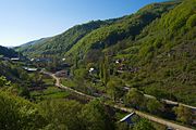 Valea Mănăstirii
 -
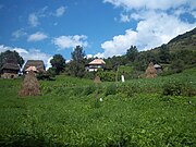 Valea Poienii
Râmeț | |
|---|---|
 Râmeț Monastery | |
 Location in Alba County | |
 Râmeț Location in Romania | |
| Coordinates: 46°18′N 23°32′E / 46.300°N 23.533°E | |
| Country | Romania |
| County | Alba |
| Government | |
| • Mayor (2020–2024) | Vasile Raica [1] ( PSD) |
| Area | 79.44 km2 (30.67 sq mi) |
| Elevation | 473 m (1,552 ft) |
| Highest elevation | 805 m (2,641 ft) |
| Population (2021-12-01)
[2] | 426 |
| • Density | 5.4/km2 (14/sq mi) |
| Time zone | EET/ EEST (UTC+2/+3) |
| Postal code | 517590 |
| Area code | (+40) 02 58 |
| Vehicle reg. | AB |
| Website |
www |
Râmeț ( German: Einsiedel; Hungarian: Remete) is a commune located in Alba County, Transylvania, Romania. It is composed of thirteen villages: Boțani, Brădești (Fenyősremete), Cheia (Remeteiszoros), Cotorăști, Florești, Olteni (Szabaderdő), Râmeț, Valea Făgetului, Valea Inzelului, Valea Mănăstirii (Remetekolostor), Valea Poienii, Valea Uzei and Vlădești.
Tourist attractions include:
- The Romanian Orthodox Râmeț Monastery, with the old church dating to the 14th century.
- Nature reserve "Cheile Râmeților" (40 ha).
- Nature reserve "Cheile Pravului" (3 ha), in Cheia.
- Nature reserve "Cheile Piatra Bălții" (2 ha), in Cheia.
- Nature reserve "Cheile Mănăstirii" (15 ha), in Valea Mănăstirii.
- Nature reserve "Vânătările Ponorului", near the Bedeleu peak in the Trascău Mountains.
References
- ^ "Results of the 2020 local elections". Central Electoral Bureau. Retrieved 6 June 2021.
- ^ "Populaţia rezidentă după grupa de vârstă, pe județe și municipii, orașe, comune, la 1 decembrie 2021" (XLS). National Institute of Statistics.


|
| This Alba County location article is a stub. You can help Wikipedia by expanding it. |