 | |
| Location | Peru, Cusco Region, Anta Province, Chinchaypujio District |
|---|---|
| Region | Andes |
| Coordinates | 13°36′49.8″S 72°15′45.1″W / 13.613833°S 72.262528°W |
| Type | Temple |
| Length | 1,109 m |
| Width | 1,109 m |
| Area | 7.12Ha |
| History | |
| Cultures | Inca Empire |
| Site notes | |
| Archaeologists | Max Uhle, Ken Heffernan |
| Public access | yes |
Qullmay is an Inca Empire archeological site with multiple buildings along a Granite cliff, assumed to be used for both administrative and religious practices. [1] [2] It is located in the Cusco Region, Anta Province, Chinchaypujio District at 3,436 m altitude. [3] Qollmay is 4 km North-West (about a 25-minute drive on dirt road) from Chinchaypujio, on the way to the campesino community of Sumaru.
First excavated by Max Uhle in 1905 and registered by Ken Heffernan in 1986, it has been classified in 6 sectors [3] and features about a dozen foundations, half a dozen well preserved walls and one well preserved walled-off natural cavern with Inca-style stonework inside, located within sector 1. This cavernous building is thought to be the most important one in the whole site. [1] Adjacent to it is a rock formation reminiscent of a Birth canal, speculated to be the site of fertility rituals.[ citation needed]
The site is embedded within Inca-made, rectangular terraces, now overgrown with grass. [2]
-
 Qollmay Archaeological Site as seen from above
 -
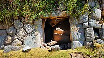 Outside of the main cave entrance
 -
 Inside of the Qollmay main building cave
 -
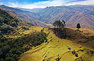 Archaeological Site as seen from above, with entire footprint of other buildings and remains.
 -
 The unpaved Serpentine Road from Chinchaypujio to Qollmay
 -
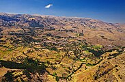 Chinchaypujio as seen from Qollmay.


See also
Further reading
References
- ^ a b "Arte rupestre Chinchaypucyo y las pinturas rupestres de Pumawasi, Provincia de Anta, Cusco Peru". www.rupestreweb.info. Retrieved 2019-08-14.
- ^ a b Silva Gonzales, José Carlos (2008). "Declaration of the Archeological Site Qollmay (Spanish)" (PDF). Geo Patrimonio Cusco. Retrieved 2019-08-14.
- ^ a b Silva Gonzales, José Carlos. "Deliminations of Qollmay" (PDF). Geopatrimonio Cusco. Retrieved 2019-08-14.
|
| This Peruvian geography article is a stub. You can help Wikipedia by expanding it. |
|
| This article about the history of Peru is a stub. You can help Wikipedia by expanding it. |
|
| This South American archaeology article is a stub. You can help Wikipedia by expanding it. |