Highway 25 | ||||
|---|---|---|---|---|
| Ruta 25 | ||||
| Avenida Juan Ponce de León | ||||
.png) | ||||
| Route information | ||||
| Maintained by Puerto Rico DTPW | ||||
| Length | 11.1 km [1] [2] (6.9 mi) | |||
| Major junctions | ||||
| South end | ||||
| ||||
| North end | Calle Fortaleza / Calle Recinto Sur in San Juan Antiguo | |||
| Location | ||||
| Country | United States | |||
| Territory | Puerto Rico | |||
| Municipalities | San Juan | |||
| Highway system | ||||
| ||||
| ||||

Avenida Juan Ponce de León, coextensive as Puerto Rico Highway 25 (PR-25) along its entire length, is one of the main thoroughfares in San Juan, Puerto Rico. [3]
Route description
It is a mostly three-lane, one-way road. It runs from Old San Juan to Río Piedras pueblo [4] and, for most of its length, it is a three- or four-lane road traversing the Isleta de San Juan corridor. The section running through Río Piedras pueblo is the only section that is not a multi-lane roadway.
-
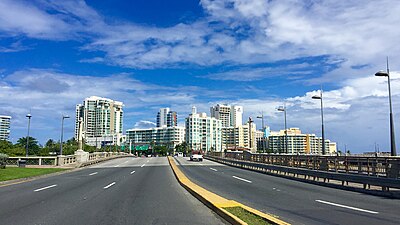 The road as it crosses over the Guillermo Esteves Bridge
 -

.jpg)
.jpg)
Urban landscape
Institutional, cultural and other notable buildings predominate along the thoroughfare and it is considered[ by whom?] as one of the main arteries in shopping errands, community participation, cultural activities and of personnel training of the city, [5] it also constitutes an attraction for its architecture. [6]
A stretch of Avenida Ponce de León has been designated as the arts district. [7] It starts in Miramar and continues towards Hato Rey for 4 miles.
-
 Casino de Puerto Rico,
1 Avenida Juan Ponce de León -
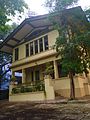
 Casa de España, Puerta de Tierra
 -
 Nuestra Señora de la Providencia
 -
-

-
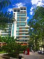 Ciudadela in Santurce
 -
 Plaza de la Convalecencia in Río Piedras Pueblo


Major intersections
The entire route is located in San Juan.
| Location | km [1] [2] [8] | mi | Destinations | Notes | |||
|---|---|---|---|---|---|---|---|
| Monacillo Urbano | 0.0 | 0.0 | Southern terminus of PR-8838 | ||||
| 1.2 | 0.75 | Southern terminus of Avenida Juan Ponce de León | |||||
| 1.8 | 1.1 | Avenida José de Diego (unsigned) | |||||
| El Cinco | 2.7 | 1.7 | |||||
| 3.0 | 1.9 | Seagull intersection; former PR-8839 | |||||
| 3.3 | 2.1 | Northern terminus of PR-8838 | |||||
| Gap in route | |||||||
|
El Cinco–
Pueblo– Hato Rey Sur tripoint | 0.0 | 0.0 | Clockwise terminus of PR-3 and western terminus of PR-847 | ||||
| Gap in route | |||||||
| Pueblo– Hato Rey Sur line | 11.1 | 6.9 | PR-3 west to PR-1 north | Southern terminus of PR-25; PR-3 westbound exit and PR-1 northbound entrance; unsigned | |||
| Universidad– Hato Rey Sur line | 10.0– 9.9 | 6.2– 6.2 | Diamond interchange | ||||
| Hato Rey Central– Hato Rey Norte line | 8.8 | 5.5 | PR-1 / PR-Calle Betances | Inbound access only; PR-1 north traffic joins PR-25 north traffic along Avenida Juan Ponce de León north | |||
| 8.4 | 5.2 | Northern terminus of PR-41 | |||||
| 8.05 | 5.00 | ||||||
| 7.7 | 4.8 | Avenida Quisqueya ( PR-40) | Inbound access only; western terminus of PR-40; eastbound access via Calle Bolivia (km 7.8) | ||||
| Caño Martín Peña | 7.0 | 4.3 | Puente de Martín Peña [9] | ||||
| Santurce | 6.85 | 4.26 | PR-1 north traffic splits onto Expreso Luis Muñoz Rivera north | ||||
| 6.5 | 4.0 | Western terminus of PR-36 | |||||
| 5.7 | 3.5 | Avenida José Fidalgo Díaz (unsigned) | |||||
| 5.2 | 3.2 | PR-37 (Avenida José de Diego / Calle Doctor Manuel Fernández Pavía) | No turn to westbound | ||||
| 5.05 | 3.14 | PR-22 exit 0A | |||||
| 4.35 | 2.70 | ||||||
| 3.8 | 2.4 | One-way street; northern terminus of PR-39 | |||||
| 2.9 3.35 [a] | 1.8 2.08 | Southern terminus of PR-1 concurrency; northern terminus of PR-16 and Avenida Juan Ponce de León, and western terminus of PR-26 | |||||
| Caño de San Antonio | 3.25 [a] | 2.02 | Puente Guillermo Esteves and Puente San Antonio [9] | ||||
| San Juan Antiguo | 3.05
[a] 2.8 | 1.90 1.7 | Northern terminus of PR-1 concurrency; southern terminus of PR-25P and Avenida de la Constitución | ||||
| 1.0 | 0.62 | Paseo Covadonga ( PR-38) | Inbound access only; eastern terminus of PR-38; westbound access via Calle Reverendo Gerardo Dávila (km 0.75) | ||||
| 0.0 | 0.0 | Avenida Luis Muñoz Rivera ( PR-25P) / Calle del Recinto Sur | Northern terminus of PR-25, PR-25P and Avenida de la Constitución | ||||
| Calle de la Fortaleza | Continuation beyond PR-25P | ||||||
1.000 mi = 1.609 km; 1.000 km = 0.621 mi
| |||||||
Related route
Highway 25R | |
|---|---|
| Location | San Juan |
| Length | 2.7 km [10] (1.7 mi) |
Puerto Rico Highway 25R ( Spanish: Carretera Ramal 25, abbreviated Ramal PR-25 or PR-25R) is a one way avenue in San Juan. The road begins at Avenida de la Constitución (PR-25) in Old San Juan, heading through a one-way highway along the Atlantic Ocean, and going back through to the concurrency of PR-25 and PR-1 in Puerta de Tierra. [4] The entire route is located in San Juan Antiguo, San Juan.
| km [10] | mi | Destinations | Notes | ||
|---|---|---|---|---|---|
| 2.7 | 1.7 | PR-1 | Southern terminus of PR-25R | ||
| 0.0 | 0.0 | Avenida de la Constitución (PR-25 south) / Calle de la Fortaleza | One-way streets; northern terminus of PR-25R and PR-25 | ||
| Calle del Recinto Sur | Continuation beyond PR-25 | ||||
| 1.000 mi = 1.609 km; 1.000 km = 0.621 mi | |||||
See also
References
- ^ a b Google (28 February 2020). "PR-25 north" (Map). Google Maps. Google. Retrieved 28 February 2020.
- ^ a b Google (28 February 2020). "PR-25 south" (Map). Google Maps. Google. Retrieved 28 February 2020.
- ^ National Geographic Maps (2011). Puerto Rico (Map). 1:125,000. Adventure Map (Book 3107). Evergreen, Colorado: National Geographic Maps. ISBN 978-1566955188. OCLC 756511572.
- ^ a b Puerto Rico Department of Transportation and Public Works. "Datos de Transito 2000-2009" (in Spanish). Archived from the original on 1 April 2019. Retrieved 1 April 2019.
- ^ Edwin R. Quiles Rodríguez. "La Ponce de León como metáfora". 80grados (in Spanish). Retrieved 27 February 2020.
- ^ www.prfrogui.com History of the Roads of Puerto Rico-(in Spanish)-Retrieved 18 May 2018.
- ^ Avenida de las Artes (3 November 2012). "San Juan's Arts & Culture District". Retrieved 27 February 2020.
- ^ Google (28 February 2020). "PR-8838" (Map). Google Maps. Google. Retrieved 28 February 2020.
- ^ a b Luis F. Pumarada O’Neill (1991). "Los Puentes Históricos de Puerto Rico" (PDF) (in Spanish). Retrieved 10 March 2020.
- ^ a b Google (13 July 2021). "PR-25R" (Map). Google Maps. Google. Retrieved 13 July 2021.
External links
- Anuncia convocatoria de arte urbano en Avenida Ponce de León (in Spanish)
- CBA de Santurce hace realidad el Pórtico de las Artes (in Spanish)
|
| This San Juan, Puerto Rico location article is a stub. You can help Wikipedia by expanding it. |
|
| This Puerto Rico road-related article is a stub. You can help Wikipedia by expanding it. |