Highway 173 | ||||
|---|---|---|---|---|
| Ruta 173 | ||||
| Route information | ||||
| Maintained by Puerto Rico DTPW | ||||
| Length | 32.2 km [1] [2] (20.0 mi) | |||
| Existed | 1953 [3]–present | |||
| Major junctions | ||||
| South end | ||||
| North end | ||||
| Location | ||||
| Country | United States | |||
| Territory | Puerto Rico | |||
| Municipalities | Aibonito, Cidra, Aguas Buenas, Guaynabo | |||
| Highway system | ||||
| ||||
| ||||


Puerto Rico Highway 173 (PR-173) is a road that travels from Aibonito, Puerto Rico to Guaynabo, passing through Cidra and Aguas Buenas. [4] This highway begins at PR-14 junction in Plata and ends at its intersection with PR-1 and PR-8834 in Río. [5]
- Puerto Rico Highway 173 by municipality
-
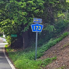 Heading north in Plata, Aibonito
 -

.jpg)
Major intersections
-
 PR-14 east at PR-173 intersection between Plata and Robles barrios, Aibonito
 -
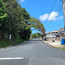
 Northern terminus of PR-173 from PR-1 and PR-8834 intersection in Río, Guaynabo
 -
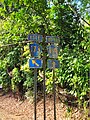
 Signs for PR-1 and PR-8834 at the northern terminus of PR-173 in Río, Guaynabo
.jpg)


| Municipality | Location | km [1] [2] | mi | Destinations | Notes |
|---|---|---|---|---|---|
| Aibonito | Robles– Plata line | 0.0 | 0.0 | Southern terminus of PR-173 | |
| Plata | 1.5 | 0.93 | |||
| 2.1– 2.2 | 1.3– 1.4 | ||||
| Cidra | Honduras | 5.8 | 3.6 | ||
| Rabanal | 6.4– 6.5 | 4.0– 4.0 | |||
| Toíta– Rabanal line | 8.0– 8.1 | 5.0– 5.0 | |||
| Rabanal | 9.0 | 5.6 | |||
| Sud– Rabanal line | 11.6– 11.7 | 7.2– 7.3 | |||
| Cidra barrio-pueblo | 12.4 12.2 [a] | 7.7 7.6 | Western terminus of PR-173 concurrency | ||
| 12.3
[a] 12.5 | 7.6 7.8 | Eastern terminus of PR-173 concurrency; one-way street; eastbound access via Calle Miguel Planellas or Calle Vicente Muñoz Barrios | |||
| Bayamón– Ceiba line | 13.8 | 8.6 | |||
| Monte Llano– Bayamón line | 15.6 | 9.7 | |||
| Aguas Buenas | Sumidero | 18.7 | 11.6 | ||
| Mula– Sumidero line | 22.9 47.6 [b] | 14.2 29.6 | Western terminus of PR-156 concurrency | ||
| Aguas Buenas barrio-pueblo | 50.0 [b] | 31.1 | |||
| 50.3
[b] 23.0 | 31.3 14.3 | Eastern terminus of PR-156 concurrency | |||
| Bairoa | 25.4 | 15.8 | |||
| Sonadora– Bairoa line | 25.5 | 15.8 | |||
| Jagüeyes– Sonadora line | 26.0 | 16.2 | |||
| 26.0– 26.1 | 16.2– 16.2 | ||||
| Guaynabo | Río | 32.2 | 20.0 | Northern terminus of PR-173 | |
1.000 mi = 1.609 km; 1.000 km = 0.621 mi
| |||||
Related route
Highway 7173 | |
|---|---|
| Location | Aguas Buenas |
| Length | 1.3 km [6] (0.81 mi) |
Puerto Rico Highway 7173 (PR-7173) is a dead end road that branches off from PR-173 in Sumidero. [7] The entire route is located in Sumidero, Aguas Buenas.
| km [6] | mi | Destinations | Notes | ||
|---|---|---|---|---|---|
| 1.3 | 0.81 | Western terminus of PR-7173 at Sector Las Corujas | |||
| 0.0 | 0.0 | Eastern terminus of PR-7173 | |||
| 1.000 mi = 1.609 km; 1.000 km = 0.621 mi | |||||
See also
References
- ^ a b Google (25 March 2020). "PR-173 south" (Map). Google Maps. Google. Retrieved 25 March 2020.
- ^ a b Google (25 March 2020). "PR-173 north" (Map). Google Maps. Google. Retrieved 25 March 2020.
- ^ "Aibonito, Memoria Núm. 43" (PDF). Puerto Rico Planning Board (in Spanish). 1955. Retrieved 11 August 2020.
- ^ National Geographic Maps (2011). Puerto Rico (Map). 1:125,000. Adventure Map (Book 3107). Evergreen, Colorado: National Geographic Maps. ISBN 978-1566955188. OCLC 756511572.
- ^ "Tránsito Promedio Diario (AADT)". Puerto Rico Department of Transportation and Public Works (in Spanish). p. 91. Archived from the original on 1 April 2019. Retrieved 19 June 2019.
- ^ a b Google (1 March 2020). "PR-7173" (Map). Google Maps. Google. Retrieved 1 March 2020.
- ^ "Avenida Las Corujas, Sumidero". www.cartogiraffe.com. Retrieved 1 February 2022.
External links
-
 Media related to
Puerto Rico Highway 173 at Wikimedia Commons
Media related to
Puerto Rico Highway 173 at Wikimedia Commons
|
| This Puerto Rico road-related article is a stub. You can help Wikipedia by expanding it. |