Highway 165 | |||||||||
|---|---|---|---|---|---|---|---|---|---|
| Ruta 165 | |||||||||
| Route information | |||||||||
| Maintained by Puerto Rico DTPW | |||||||||
| Length | 38.9 km [1] [2] (24.2 mi) | ||||||||
| Existed | 1953 [3]–present | ||||||||
| Major junctions | |||||||||
| West end | |||||||||
| |||||||||
| East end | |||||||||
| Location | |||||||||
| Country | United States | ||||||||
| Territory | Puerto Rico | ||||||||
| Municipalities | Naranjito, Toa Alta, Dorado, Toa Baja, Cataño, Guaynabo | ||||||||
| Highway system | |||||||||
| |||||||||
| |||||||||


Puerto Rico Highway 165 (PR-165) is the road that goes from Naranjito to Guaynabo. The highway passes by Toa Alta, Toa Baja, Dorado, Levittown, Cataño and Guaynabo. [4]
Route description
This highway begins at its junction with PR-164 (road from Naranjito to Corozal) and ends at San Patricio (near Caparra). From Naranjito to Toa Alta it is a rural road. In Toa Baja it becomes a divided highway. In Dorado the road is one lane in each direction and parallel to the northern coast of Puerto Rico. In Levittown it becomes a divided highway before ending at San Patricio. In Cataño it is a short highway which begins at the Bacardi Distillery and ends at the Federal Prison. [4]
- Puerto Rico Highway 165
-
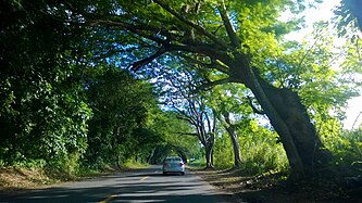 Heading south in Río Lajas, Dorado
 -
 Heading south to Río Lajas and Toa Alta in La Virgencita, Dorado
.jpg)
.jpg)
Major intersections
-

-
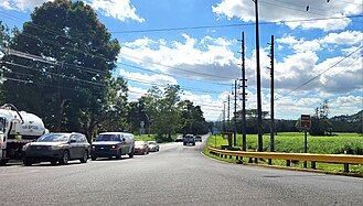
 PR-2 east near PR-165 interchange in Media Luna, Toa Baja
 -
 PR-165 south at PR-22 interchange in Media Luna, Toa Baja
 -
 PR-22 east approaching exits 7A-B to PR-165 in Pueblo Viejo, Guaynabo

.jpg)


| Municipality | Location | km [1] [2] | mi | Exit | Destinations | Notes |
|---|---|---|---|---|---|---|
| Naranjito | Lomas | 0.0 | 0.0 | Southern terminus of PR-165 | ||
| Toa Alta | Quebrada Cruz– Quebrada Arenas line | 4.7 | 2.9 | |||
|
Quebrada Arenas–
Quebrada Cruz– Galateo tripoint | 5.8 | 3.6 | ||||
| Galateo | 6.7– 6.8 | 4.2– 4.2 | ||||
| Contorno– Galateo line | 8.2 | 5.1 | Access to Río Lajas | |||
| Contorno | 10.6 | 6.6 | ||||
| 10.7– 10.8 | 6.6– 6.7 | |||||
| 11.4– 11.5 | 7.1– 7.1 | Roundabout | ||||
| Dorado | Río Lajas | 11.8 | 7.3 | |||
| 13.6 23.5 [a] | 8.5 14.6 | Western terminus of PR-2 concurrency | ||||
| Río de la Plata | 23.4 [a] | 14.5 | Puente de la Virgencita | |||
| Toa Baja | Media Luna | 22.9 [a] | 14.2 | |||
| 22.6
[a] 13.7 | 14.0 8.5 | 14 | Eastern terminus of PR-2 concurrency; trumpet interchange | |||
| 14.3– 14.7 | 8.9– 9.1 | 15 | PR-22 exits 22, 22A and 22B; partial cloverleaf interchange; southbound exits signed as 15A and 15B; no exit number northbound | |||
| 15.0 | 9.3 | |||||
| Media Luna– Sabana Seca line | 17.4 | 10.8 | ||||
| Dorado | Mameyal | 18.6 | 11.6 | |||
| Toa Baja | Sabana Seca | 26.7– 26.8 | 16.6– 16.7 | |||
| 29.6– 29.7 | 18.4– 18.5 | |||||
| Palo Seco | 31.1– 31.2 | 19.3– 19.4 | ||||
| Cataño | Palmas | 31.7– 31.8 | 19.7– 19.8 | |||
| 32.3– 32.4 | 20.1– 20.1 | |||||
| 34.5– 35.1 | 21.4– 21.8 | — | Diamond interchange | |||
| Guaynabo | Pueblo Viejo | 36.5– 36.9 | 22.7– 22.9 | — | ||
| 37.1– 37.2 | 23.1– 23.1 | |||||
| 37.4– 37.9 | 23.2– 23.5 | PR-22 exits 7A and 7B; partial cloverleaf interchange | ||||
| 38.9 | 24.2 | Northern terminus of PR-165 | ||||
1.000 mi = 1.609 km; 1.000 km = 0.621 mi
| ||||||
Related routes
Currently, Puerto Rico Highway 165 has two branches along its route. One of them is located in Toa Alta and the other is in Dorado.
Puerto Rico Highway 165R
Highway 165R | |
|---|---|
| Location | Toa Alta |
| Length | 0.65 km [5] (0.40 mi; 2,100 ft) |
Puerto Rico Highway 165R ( Spanish: Carretera Ramal 165, abbreviated Ramal PR-165 or PR-165R) is the road that goes to downtown Toa Alta, Puerto Rico. This road can be seen as the Business 165, since this road was the PR-165 through the area from the town center. [6] The entire route is located in Toa Alta.
-
 PR-165 north near PR-165R intersection in Contorno barrio
 -
 PR-165R north in Contorno barrio
 -
 PR-165R north entering downtown Toa Alta
 -
 PR-165R south approaching PR-165 junction in Contorno barrio

.jpg)
.jpg)

| Location | km [5] | mi | Destinations | Notes | |
|---|---|---|---|---|---|
| Contorno | 0.00 | 0.00 | Southern terminus of PR-165R; access to Naranjito, Dorado and Toa Baja | ||
| Toa Alta barrio-pueblo | 0.65 | 0.40 | PR-861 | Northern terminus of PR-165R; unsigned | |
| 1.000 mi = 1.609 km; 1.000 km = 0.621 mi | |||||
Puerto Rico Highway 6165
Highway 6165 | |
|---|---|
| Location | Dorado |
| Length | 0.8 km [7] (0.50 mi; 2,600 ft) |
Puerto Rico Highway 6165 (PR-6165) is the road that goes to downtown Dorado, Puerto Rico from PR-165. This road can be seen as the Business spur 165 because it connects PR-165 with PR-693 in downtown area. [6] The entire route is located in Dorado.
-
 Old sign for PR-165R in Dorado
 -
 Bridge on Calle Méndez Vigo (PR-6165) in Dorado
 -
 View of the La Plata River from bridge on Calle Méndez Vigo (PR-6165)
 -
 Sign for PR-6165 intersection in Dorado


| Location | km [7] | mi | Destinations | Notes | |
|---|---|---|---|---|---|
| Dorado barrio-pueblo | 0.0 | 0.0 | Western terminus of PR-6165; access to Hyatt Residence Club Dorado | ||
| Mameyal | 0.5 | 0.31 | Northern terminus of PR-854 | ||
| 0.8 | 0.50 | Eastern terminus of PR-6165; access to San Juan | |||
| 1.000 mi = 1.609 km; 1.000 km = 0.621 mi | |||||
See also
References
- ^ a b Google (2 March 2020). "PR-165 west" (Map). Google Maps. Google. Retrieved 2 March 2020.
- ^ a b Google (2 March 2020). "PR-165 east" (Map). Google Maps. Google. Retrieved 2 March 2020.
- ^ "Naranjito, Memoria Núm. 53" (PDF). Puerto Rico Planning Board (in Spanish). 1955. Retrieved 4 August 2020.
- ^ a b "Tránsito Promedio Diario (AADT)". Transit Data (Datos de Transito) (in Spanish). DTOP PR. pp. 87–88. Archived from the original on 1 April 2019.
- ^ a b Google (2 March 2020). "PR-165R" (Map). Google Maps. Google. Retrieved 2 March 2020.
- ^ a b National Geographic Maps (2011). Puerto Rico (Map). 1:125,000. Adventure Map (Book 3107). Evergreen, Colorado: National Geographic Maps. ISBN 978-1566955188. OCLC 756511572.
- ^ a b Google (2 March 2020). "PR-6165" (Map). Google Maps. Google. Retrieved 2 March 2020.
External links
-
 Media related to
Puerto Rico Highway 165,
Puerto Rico Highway 165R and
Puerto Rico Highway 6165 at Wikimedia Commons
Media related to
Puerto Rico Highway 165,
Puerto Rico Highway 165R and
Puerto Rico Highway 6165 at Wikimedia Commons - PR-165, Toa Alta, Puerto Rico