Highway 123 | ||||
|---|---|---|---|---|
| Ruta 123 | ||||
.svg) | ||||
| Route information | ||||
| Maintained by Puerto Rico DTPW | ||||
| Length | 78.40 km [1] (48.72 mi) | |||
| Existed | circa 1910–present | |||
| Major junctions | ||||
| South end | ||||
| ||||
| North end | ||||
| Location | ||||
| Country | United States | |||
| Territory | Puerto Rico | |||
| Municipalities | Ponce, Adjuntas, Utuado, Arecibo | |||
| Highway system | ||||
| ||||
Carretera Núm. 6 | ||||
| Location | Ponce, Puerto Rico | |||
| Built | 19th-century | |||
| NRHP reference No. | 100006919 | |||
| Added to NRHP | September 14, 2021 | |||


Puerto Rico Highway 123 (PR-123) is a secondary highway that connects the city Arecibo to the city of Ponce. It runs through the towns of Utuado and Adjuntas, before reaching Ponce. [1] A parallel road is being built, PR-10, that is expected to take on most of the traffic currently using PR-123.
History
The road dates from the late 19th century and it started as a road to link the coffee-farming mountain town of Adjuntas to the southern port city of Ponce for the export of coffee. [2] (Eventually the road was completed to the smaller northern port city of Arecibo as well, connecting the mountain town of Utuado in its way.) PR-123 was built under the colonial government of Spain in Puerto Rico to connect the coffee-growing town of Adjuntas to the port city of Ponce as a farm-to-market road. [3] By the early 20th century, it was already graced with many bungalow-style summerhouses. [4]
The construction of the first Ponce-to-Adjuntas road got underway through the dedicated efforts of local political leader, attorney, and composer Olimpio Otero in the late nineteenth century. [5] In 1887, the Ponce Municipal Assembly issued a resolution to use vagrants in the construction of this road, to add to the labor already being performed by prisoners. [6] In 1903, the Puerto Rico Legislature named a bridge on the Ponce to Adjuntas section of the road to his memory for his outstanding dedication to the building of that stretch of the road. [3] The bridge is located in the Magueyes barrio of the municipality of Ponce. During his 1910 surveys, American surveyor William H. Armstrong called the road "a beautiful work of engineering." [7] According to Armstrong, the road was 29 kilometers long and had 87 bridges and culverts.
-
 Bridge on the PR-123 road from Ponce to Adjuntas, ca. 1890s
 -
 The Ponce-Adjuntas Road in Ponce in 1899


True to its farm-to-market purpose, PR-123 was designed to descend from the mountain town of Adjuntas and make its way through the Cordillera Central until it reached the city of Ponce, edging Plaza Las Delicias, located just two blocks from the Plaza del Mercado de Ponce fruits-and-vegetables central market place. The road then continued south, via Avenida Hostos, to the port of Ponce where coffee and other farm products were shipped to the United States and Europe. Under the Plan Ponce en Marcha, Avenida Hostos will be enlarged from two to four lanes. [8]
PR-123 was signed PR-10 until a new and wider parallel road was built (see PR-10) which adopted its number. [9] [10] [11] This route signing for this old, winding road can still be seen in some old street maps of the city of Ponce. [12]
The stretch from Ponce to Adjuntas was built under the Spanish government. The remainder of the route to Arecibo was built after the Americans took over in 1898. [13] This second stretch opened on July 1, 1904. The whole course of the road from its southern end in Ponce to its northern end in Arecibo was signed as Road No. 6 in those days. [14] [15]
Navigating this first PR-10 road was very tedious as the road was engineered to run from mountainside to mountainside, following the contours of the mountains, and along the natural definitions of the course of rivers, to reach its destination. Such design, however, limited considerably the speed of travel. It was also necessary to drive through the congested downtown areas of the various towns and villages in the way to get from one terminus of the road to the other, something that proved to be very time-consuming as vehicular traffic in those towns and villages increased. Despite these drawbacks, the road was heavily used for many decades. However, as traffic on this road increased in the 1950s and 1960s, the road started to show its limits.
The completed road had a length of 82 km. [16]
-
 The Ponce–Adjuntas Road in Ponce in 1920, now a section of PR-123
 -
 Another view of a section of the Ponce-Adjuntas Road in 1920


Construction details
The road was built in 13 segments as follows: [17]
| Section No. | Begin km (mi) | End km (mi) | Length | Town | Builder(s) | Year begun | Year ended | Cost |
|---|---|---|---|---|---|---|---|---|
| 1 | 0.0 (0) | 15.0 (9.3) | 15.0 (9.3) | Ponce | Spain | unknown | pre-1898 | $146,333.08 |
| 2 | 15.0 (9.3) | 21.0 (13.0) | 6.0 (3.7) | – | PR | 1903 | $90,000.00 | |
| 3 | 21.0 (13.0) | 24.0 (14.9) | 3.0 (1.9) | – | US | unknown | 1901 | $42,527.28 |
| 4 | 24.0 (14.9) | 24.3 (15.1) | 0.3 (0.19) | – | Spain/US | <1898 | 1900 | $17,451.21 |
| 5 | 24.3 (15.1) | 30.1 (18.7) | 5.8 (3.6) | Adjuntas | US | unknown | 1901 | $85,053.72 |
| 6 | 30.1 (18.7) | 32.0 (19.9) | 1.9 (1.2) | – | US | unknown | 1900 | $28,858.92 [a] |
| 7 | 32.0 (19.9) | 38.0 (23.6) | 6.0 (3.7) | – | PR | 1899 | unknown | * [b] |
| 8 | 38.0 (23.6) | 43.2 (26.8) | 5.2 (3.2) | – | PR | unknown | 1903 | $79,000.00 |
| 9 | 43.2 (26.8) | 50.5 (31.4) | 7.3 (4.5) | Utuado | PR | 1899 | 1926? | $118,006.19 |
| 10 | 50.5 (31.4) | 55.0 (34.2) | 4.5 (2.8) | – | Spain | unknown | 1876 | $115,224.98 |
| 11 | 55.0 (34.2) | 64.3 (40.0) | 9.3 (5.8) | – | PR | 1901 | 1926? | $123,658.67 |
| 12 | 64.3 (40.0) | 69.0 (42.9) | 4.7 (2.9) | – | PR | <1898 | 1901 | $36,520.00 |
| 13 | 69.0 (42.9) | 81.5 (50.6) | 12.5 (7.8) | Arecibo | PR | 1898 | 1902 | $125,850.23 |
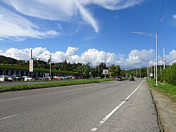
Characteristics
The road is prone to landslides and closings due to frequent heavy rains. [18]
-
 Pier at the end of PR-123, near El Ancla in Playa, Ponce - near the Southern terminus of PR-123
 -
-
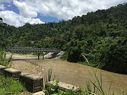 Río de Caguana as seen from PR-123 in Utuado
 -
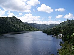 Lago Dos Bocas, view from the bridge on the dam facing south, PR-123

.jpg)


Major intersections
| Municipality | Location |
km [19] [20] [21] [22] | mi | Destinations | Notes |
|---|---|---|---|---|---|
| Ponce | Playa | 0.0 | 0.0 | Southern terminus of PR-123 | |
| 1.6 | 0.99 | Southern terminus of the Carretera Central | |||
| 1.7– 1.8 | 1.1– 1.1 | ||||
| 3.2 | 2.0 | Puente del Río Portugués over the Río Portugués | |||
| 3.5 | 2.2 | ||||
| Canas Urbano | 4.3– 4.4 | 2.7– 2.7 | |||
| Primero– Cuarto line | 4.6 | 2.9 | One-way streets; the Carretera Central continues toward Juana Díaz; PR-123P southbound access via Calle Aurora | ||
|
Primero–
Cuarto– Segundo– Tercero quadripoint | 5.2 | 3.2 | One-way streets | ||
| Primero– Segundo line | 5.3 | 3.3 | One-way streets; PR-14R northbound access via PR-14 | ||
| 5.5 | 3.4 | One-way street; northbound access via PR-1P | |||
|
Segundo–
Canas Urbano– Primero tripoint | 6.3 | 3.9 | |||
| Canas Urbano | 7.3 | 4.5 | |||
| Magueyes Urbano | 9.8 | 6.1 | |||
| Magueyes | 10.9 | 6.8 | |||
| Guaraguao | 21.6 | 13.4 | |||
| 24.4 | 15.2 | ||||
| 25.0– 25.1 | 15.5– 15.6 | ||||
| Adjuntas | Saltillo | 30.6 | 19.0 | Southern terminus of the Ruta Panorámica concurrency; the Ruta Panorámica continues toward Utuado | |
| Adjuntas barrio-pueblo | 34.3 | 21.3 | Northern terminus of the Ruta Panorámica concurrency; the Ruta Panorámica continues toward Lares | ||
| 35.3– 35.4 | 21.9– 22.0 | One-way streets; PR-521 access via Calle Rius Rivera | |||
| 35.7– 35.8 | 22.2– 22.2 | Puente Chavier over the Río Cidra [23] | |||
| Garzas | 37.5 | 23.3 | |||
| Juan González | 37.7 | 23.4 | |||
| 38.0 | 23.6 | ||||
| 38.1 | 23.7 | One-way ramp; southbound access via PR-5518 | |||
| Pellejas | 44.7 | 27.8 | |||
| Utuado | Arenas | 48.7 | 30.3 | Puente Blanco over the Río Pellejas [23] | |
| 49.5 | 30.8 | ||||
| 53.5 | 33.2 | ||||
| Utuado barrio-pueblo | 55.4– 55.5 | 34.4– 34.5 | |||
| 55.5– 55.6 | 34.5– 34.5 | ||||
| 55.6– 55.7 | 34.5– 34.6 | Puente de Utuado over the Río Grande de Arecibo [23] | |||
| 55.7 60.6 [a] | 34.6 37.7 | Eastern terminus of PR-111 concurrency | |||
| 60.3
[a] 55.8 | 37.5 34.7 | Western terminus of PR-111 concurrency | |||
| Río Abajo | 59.9– 60.0 | 37.2– 37.3 | |||
| Arecibo | Río Arriba | 68.8 | 42.8 | ||
| 70.5– 70.6 | 43.8– 43.9 | ||||
| 70.6 | 43.9 | ||||
| Hato Viejo | 78.40 | 48.72 | Northern terminus of PR-123; partial cloverleaf interchange; no entrance ramp to PR-10 southbound | ||
1.000 mi = 1.609 km; 1.000 km = 0.621 mi
| |||||
See also
References
- ^ a b "Tránsito Promedio Diario (AADT)". Transit Data (Datos de Transito) (in Spanish). DTOP PR. pp. 69–71. Archived from the original on 1 April 2019.
- ^ First Annual Register of Porto Rico, July, 1901. William H. Hunt, Secretary of Porto Rico. Puerto Rico Secretary's Office. July 1901. page 193. Accessed 20 February 2018.
- ^ a b A Resolution to Name and Designate "Otero Viaduct" a Certain Highway Bridge on the Section of the Arecibo-Ponce Road within the Municipality of Ponce. Acts of the Legislature of Puerto Rico. Approved 12 March 1903. By the Legislative Assembly of Puerto Rico. pp. 149-150. Retrieved 11 April 2010.
- ^ Elements to Bear in Mind about Ponce Architecture. Jorge Ortiz Colom. Instituto de Cultura Puertorriqueña, Ponce Office. November 2007. Page 8. Accessed 20 March 2018.
- ^ Legislative Assembly of Puerto Rico. A Resolution to Name and Designate "Otero Viaduct" a Certain Highway Bridge on the Section of the Arecibo-Ponce Road within the Municipality of Ponce. Acts of the Legislature of Puerto Rico. Approved 12 March 1903. pp. 149-150. Retrieved 11 April 2010.
- ^ Ileana M. Rodriguez-Silva. Silencing Race: Disentangling Blackness, Colonialism, and National Identities in Puerto Rico. New York. Palgrave Macmillan. 2012. p. 98.
- ^ Progressive Map of Porto Rico. By William H. Armstrong, First Lieutenant, Military Information Division. Puerto Rico Regiment, United States Army Corps of Engineers. Manuscritos - William Armstrong-Libro 1, Book 1: Describing roads in the jurisdictions of Jayuya, Sabana Grande, Juana Díaz, Lajas, Guánica, Yauco, Guayanilla, Adjuntas, Ponce, and Peñuelas. Coleccion Puertorriqueña, Universidad de Puerto Rico, Rio Piedras. Via "Biblioteca Virtual de Puerto Rico". (Original source: Biblioteca Digital Puertorriqueña http://bibliotecadigital.uprrp.edu/cdm/landingpage/collection/william) Published: 12 September 2016. Page 99. Accessed 22 November 2018.
- ^ Carmelo Rosario Natal. Ponce En Su Historia Moderna: 1945-2002. Published by Secretaría de Cultura y Turismo of the Government of the Autonomous Municipality of Ponce. Ponce, Puerto Rico. 2003. p. 298.
- ^ Abandonados los caminos y carreteras rurales. Eduardo L. Questell Rodríguez. Es Noticia. 5 July 2019. Accessed 6 July 2019. (Digital edition: Abandonados los caminos y carreteras rurales. Eduardo L. Questell Rodríguez. Es Noticia. 5 to 18 July 2019. p. 13.])
- ^ Avanza Construccion del Anillo de Circunvalacion. Archived 14 August 2014 at the Wayback Machine Amado Vega Velazquez. Periodico El Señorial. Government of the Municipality of Ponce, Puerto Rico. Año 2014. Edicion Especial. May 2014. page 3. Retrieved 13 August 2014.
- ^ Neysa Rodriguez Deynes, Rafael J. Torres Torres, and Carlos Aneiro Perez. Brevario Sobre la Historia de Ponce y sus Principales Lugares de Interes. Published by Secretaría de Cultura y Turismo of the Government of the Autonomous Municipality of Ponce. Ponce, Puerto Rico. 1st edition. 1991. p. 143.
- ^ Ponce Topographic Map. Map Styles: Map and Shaded. Trails.com. From: United States Geological Survey. Topo Map. Projection: NAD83/WGS84. Retrieved 20 September 2010.
- ^ The Commercial Guide and Business Directory of Porto Rico. New York: F.E. Platt, publisher. June 10, 1910. pp. 287-288. Accessed 16 November 2010.
- ^ Annual report of the Secretary of War. United States War Department. 1915. p. 280.
- ^ "Carretera Núm. 6" (PDF). Retrieved 30 July 2023.
- ^ "La Carretera Central: Su Historia." Progreso en la Construccion de Carreteras en Puerto Rico. (Table) Juan E. Castillo. Revista de Obras Publicas de Puerto Rico (Puerto Rico Public Works Journal). Year VII. Number 4. (April 1930) p.100. Accessed 8 February 2018.
- ^ History of Construction of Road No. 6 Ponce and Arecibo. Archivo General de Puerto Rico Mapoteca. 1903. Accessed 16 October 2018.
- ^ Guaraguao: al ras de la desesperación. Jason Rodríguez Grafal. La Perla del Sur. Ponce, Puerto Rico. Year 30. Issue 1479. Page 12. 4 April 2012. Retrieved 4 April 2012.
- ^ Google (27 March 2020). "PR-123 south" (Map). Google Maps. Google. Retrieved 27 March 2020.
- ^ Google (27 March 2020). "PR-123 south central" (Map). Google Maps. Google. Retrieved 27 March 2020.
- ^ Google (27 March 2020). "PR-123 north central" (Map). Google Maps. Google. Retrieved 27 March 2020.
- ^ Google (27 March 2020). "PR-123 north" (Map). Google Maps. Google. Retrieved 27 March 2020.
- ^ a b c Luis F. Pumarada O’Neill (1991). "Los Puentes Históricos de Puerto Rico" (PDF) (in Spanish). Retrieved 26 March 2020.
Further reading
- Fay Fowlie de Flores. Ponce, Perla del Sur: Una Bibliográfica Anotada. Second Edition. 1997. Ponce, Puerto Rico: Universidad de Puerto Rico en Ponce. p. 110. Item 564. LCCN 92-75480
- Eugenio Astol. "El diputado 'Carretera'". Puerto Rico Ilustrado. 16 de mayo de 1936. pp. 13, 66. (Colegio Universitario Tecnológico de Ponce, CUTPO)
External links
- Arecibo-Ponce Road c. 1930
- The Ponce-Adjuntas Road c. 1940s–1950s
- Juana Matos Bridge in Barrio Magueyes, Ponce, Puerto Rico c. 1908
- Another view of the Juana Matos Bridge on the Ponce-Adjuntas Road in Barrio Magueyes, Ponce, Puerto Rico c. 1908
- Abandoned Bus Stop at the intersection of PR-123 and PR-524 in Barrio Pellejas, Adjuntas