Puerto Rico, Caquetá | |
|---|---|
Municipality and town | |
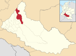
 Location of the municipality and town of Puerto Rico, Caquetá in the Caquetá Department of Colombia. | |
| Country | |
| Department | Caquetá Department |
| Population (2020 est.
[1]) | |
| • Total | 33,765 |
| Time zone | UTC-5 (Colombia Standard Time) |
Puerto Rico is a town and municipality in Caquetá Department, Colombia.
Climate
Puerto Rico has a very wet tropical rainforest climate (Af).
| Climate data for Puerto Rico | |||||||||||||
|---|---|---|---|---|---|---|---|---|---|---|---|---|---|
| Month | Jan | Feb | Mar | Apr | May | Jun | Jul | Aug | Sep | Oct | Nov | Dec | Year |
| Mean daily maximum °C (°F) | 31.5 (88.7) |
31.4 (88.5) |
30.6 (87.1) |
29.7 (85.5) |
29.4 (84.9) |
28.6 (83.5) |
28.4 (83.1) |
29.3 (84.7) |
30.1 (86.2) |
30.4 (86.7) |
30.4 (86.7) |
30.8 (87.4) |
30.1 (86.1) |
| Daily mean °C (°F) | 26.6 (79.9) |
26.8 (80.2) |
26.5 (79.7) |
26.2 (79.2) |
25.8 (78.4) |
25.2 (77.4) |
25.0 (77.0) |
25.4 (77.7) |
25.9 (78.6) |
26.2 (79.2) |
26.3 (79.3) |
26.4 (79.5) |
26.0 (78.8) |
| Mean daily minimum °C (°F) | 21.8 (71.2) |
22.2 (72.0) |
22.5 (72.5) |
22.7 (72.9) |
22.3 (72.1) |
21.9 (71.4) |
21.6 (70.9) |
21.6 (70.9) |
21.8 (71.2) |
22.1 (71.8) |
22.3 (72.1) |
22.1 (71.8) |
22.1 (71.7) |
| Average rainfall mm (inches) | 107.8 (4.24) |
199.1 (7.84) |
377.5 (14.86) |
495.3 (19.50) |
540.0 (21.26) |
497.6 (19.59) |
408.7 (16.09) |
324.9 (12.79) |
350.0 (13.78) |
351.7 (13.85) |
278.6 (10.97) |
132.3 (5.21) |
4,063.5 (159.98) |
| Average rainy days | 10 | 14 | 20 | 24 | 26 | 26 | 25 | 23 | 20 | 22 | 19 | 12 | 241 |
| Source: [2] | |||||||||||||
References
- ^ "Resultados y proyecciones (2005-2020) del censo 2005". Retrieved 19 April 2020.
- ^ "Data". www.ideam.gov.co. Retrieved 2020-07-06.
1°54′51″N 75°08′42″W / 1.91417°N 75.145°W

