Puerto Peñasco Municipality | |
|---|---|
 Seal | |
 Location of the municipality in Sonora. | |
| Country | |
| State | Sonora |
| Capital | Puerto Peñasco |
| Population (2015) | |
| • Total | 62,177 [1] |
| Time zone | UTC-7 ( Mountain Standard Time) |
| • Summer ( DST) | UTC-7 (No DST) |
Puerto Peñasco Municipality is a municipality in the Mexican state of Sonora in north-western Mexico. [2] As of 2015, the municipality had a total population of 62,177 inhabitants. [1] The only locality with a significant population is the municipal seat, also named Puerto Peñasco, which contains almost 99% of the municipality's population.
Most of the municipality consists of empty stretches of the Gran Desierto de Altar (Altar Desert) adjacent to and south of the international border with the U.S. state of Arizona.
Geography
The municipality lies at the northern end of the Gulf of California (Sea of Cortez).
As municipal seat, the city of Puerto Peñasco has governing jurisdiction over 27 other named communities, [3] which cover a territory of 9,774.5 square kilometres (3,774.0 sq mi). [4] The municipality has a total population of 62,177 inhabitants. [1] The municipality borders with the municipalities of San Luis Río Colorado Municipality, Plutarco Elías Calles Municipality, and Caborca Municipality. To its north-northwest is Yuma County, Arizona, in the United States, and to the south is the Gulf of California. [4]
Adjacent municipalities (municipios) and counties
- San Luis Río Colorado Municipality - west
- Caborca Municipality - southeast
- Plutarco Elías Calles Municipality - northeast
- Yuma County, Arizona - northwest
The municipality

The land is generally flat with the small mountain range of Sonoyta to the north and east of the area. Most of the territory is the Altar Desert, which extends north and east of the city, and a volcanic zone called Sierra El Pinacate. [4] [5] The municipality has 110 km of beaches. [6] Near the city are fields of sand dunes of the Altar Desert, which is one of the driest in the world. [4] ATVs and motocross are permitted on the sand dunes. [7] Most vegetation and animal life is typical for sandy deserts, scrub brush, reptiles (including the Gila monster) and small mammals. [4]
Farming and livestock is nearly non-existent due to the dry conditions. Some industry exists, associated with fishing such as canning and freezing. The commercial sector of the economy support 57% of the population selling food, clothes, pharmaceuticals and other items to both the local population and to tourists. The second most important economic sector is fishing, especially shrimp fishing. [4] Tourism drives most of the commercial sector. The municipality receives about 1,000 visitors a day, with about 85% coming from the U.S. state of Arizona. [6]

El Pinacate is a volcanic region and a biosphere reserve that covers 714,556.6 hectares which covers parts of the municipalities of Puerto Peñasco, San Luís Río Colorado and Plutarco Elías Calles. This area has been considered one of the most arid and inhospitable of the Sonoran Desert. In spite of this, the area contains a wide variety of wildlife and evidence of human habitation from ancient times, which has attracted the attention of both tourists and researchers. It contains 553 species of plants with cactuses such as saguaros, chollas and ocotillos dominating. With the rainy season, the area explodes with short-lived wildflowers. The area also contains 41 species of mammals, 237 species of birds, 45 species of reptiles, and four types of amphibians. It was declared a protected biosphere reserve by the Mexican government in 1993. The entrance to the biosphere park is located 50 km from the city of Puerto Peñasco. The nucleus of the biosphere consists of the Sierra el Pinacate, Adair Bay and Sierra del Rosario which cannot be developed under any circumstances. The main attraction for tourists is the volcanic craters. The major ones are named Badillo, Molina (or Trébol), McDougal (the largest) and Caravajales. In addition, there is the Grande Volcano which stands at 3,200 feet tall, and has a depth of 950 ft. [8]
San Jorge Island, also known as Bird Island, is really a small group of rocky outcroppings that are just above the surface of the sea about 40 km southeast of the city. The rocks are capped in white like the Alps, not with snow, but with the guano of innumerable sea birds such as seagulls and pelicans, which live here. Below the birds live approximately 3,000 sea lions very close to the water. It is the largest concentration of sea lions in Mexico. It is possible to kayak and/or snorkel here. [5]
Nine native cultures can be found in the municipality. The Guarijíos have a wide variety of crafts such as figures made with natural materials such as palm fronds and clay. They also make hats from a variety of natural fibers. The Mayos, who call themselves the Yoreme, have a rich oral tradition. Other groups include the Opatas, the Papagos, the Pimas, the Seris, the Yaquis, the Cucapa, and the Kikapu, all of whom are noted for basketmaking using desert plants. [9]
Government
Municipal presidents
| Municipal president | Term | Political party | Notes |
| Víctor Estrella Bustamante [10] | 1951–1954 |
PRI
|
|
| Rodolfo Rogel Villa | 1954–1957 | PRI
|
|
| Julián Bustamante | 1957–1958 | PRI
|
|
| Rafael Godoy Cisneros | 1958–1960 | PRI
|
|
| Eduardo Ibarra | 1961–1964 | PRI
|
|
| Francisco Higuera Padilla | 1964–1967 | PRI
|
|
| Gerardo Portugal Coronado | 1967–1970 | PRI
|
|
| Valente Cornejo López | 1970–1973 | PRI
|
|
| Óscar Palacio Madueño | 1973–1976 | PRI
|
|
| Gilberto Castillo Montiel | 1976–1979 | PRI
|
|
| Fernando Pérez Barnett | 1979–1982 | PRI
|
|
| Alfredo López Aceves | 1982–1985 | PRI
|
|
| Gerardo Portugal Martínez | 1985–1988 | PRI
|
|
| Genaro Alfredo Gastélum Cinco | 1988–1991 | PRI
|
|
| Fernando Martínez Vázquez [11] | 1991–1994 | PRI
|
|
| Óscar F. Palacio Soto | 1994 | PRI
|
Acting municipal president |
| Reyes Guadalupe Hernández Vega [12] | 1994–1997 | PRI
|
|
| Manuel Guillermo Flores Díaz [13] | 1997–2000 |
PAN
|
|
| José Rodrigo Vélez Acosta [14] | 2000–2003 | PRI
|
|
| Francisco Ramón Martínez González [15] [16] | 2003–2006 | PRI
|
|
| Heriberto Rentería Sánchez [17] [18] | 2006–2009 | PRI
Panal |
Coalition "Alliance PRI Sonora–Panal" |
| Alejandro Zepeda Munro [19] | 2009–2012 | PAN
|
|
| Gerardo Figueroa Zazueta [20] [21] | 2012–2015 | PRI
PVEM |
|
| Ernesto Roger Munro, Jr. [22] [23] [24] | 2015–2018 | PAN
|
|
| Ernesto Roger Munro, Jr. [25] | 2018–2021 | PAN
PRD |
Coalition "For Sonora to the Front" |
| Jorge Iván Pivac Carrillo [26] | 2021– | PAN
PRI PRD |
References
- ^ a b c "Número de habitantes. Sonora". Cuentame.inegi.org.mx. Retrieved 9 July 2018.
- ^ "-". Enciclopedia de los Municipios de México. Instituto Nacional para el Federalismo y el Desarrollo Municipal. Archived from the original on July 31, 2012. Retrieved January 4, 2010.
- ^ "INEGI Census 2010". Archived from the original on 2011-06-13.
- ^ a b c d e f "Enciclopedia de los Municipios de México Sonora Puerto Peñasco" (in Spanish). Mexico: INAFED. Archived from the original on December 1, 2008. Retrieved December 15, 2009.
- ^ a b Romo Cedano, Luis (June 2007). "Puerto Peñasco: Mar y desierto al extremo" [Puerto Peñasco:Sea and desert to the extreme]. Revista Travesias (in Spanish). Mexico. Archived from the original on September 16, 2009. Retrieved December 15, 2009.
- ^ a b "Destinos de Sonora-Puerto Peñasco" [Sonora Destinations – Puerto Peñasco] (in Spanish). Mexico: Government of Sonora. Archived from the original on 2010-03-06. Retrieved 2009-12-15.
- ^ "Sobre Puerto Peñasco" [About Puerto Peñasco] (in Spanish). Mexico: Explorando Mexico. Retrieved 2009-12-15.
- ^ "El Pinacate y Gran Desierto de Altar - Reservas Ecológicas de Sonora" [El Pinacate and the Great Altar Desert – Ecological Reserves of Sonora] (in Spanish). Mexico: Government of Sonora. Archived from the original on 2009-02-02. Retrieved 2009-12-15.
- ^ "Puerto Peñasco" (in Spanish). Buen Viaje Diario Turistico on line. Archived from the original on 2010-01-03. Retrieved 2009-12-15.
- ^ "Enciclopedia de los Municipios de México. Estado de Sonora. Puerto Peñasco" (in Spanish). Retrieved 31 March 2023.
- ^ "Mapa de Municipios gobernados por partido político. Período constitucional 1991–1994" (PDF) (in Spanish). IEES. Instituto Estatal Electoral y de Participación Ciudadana de Sonora. Retrieved 31 March 2023.
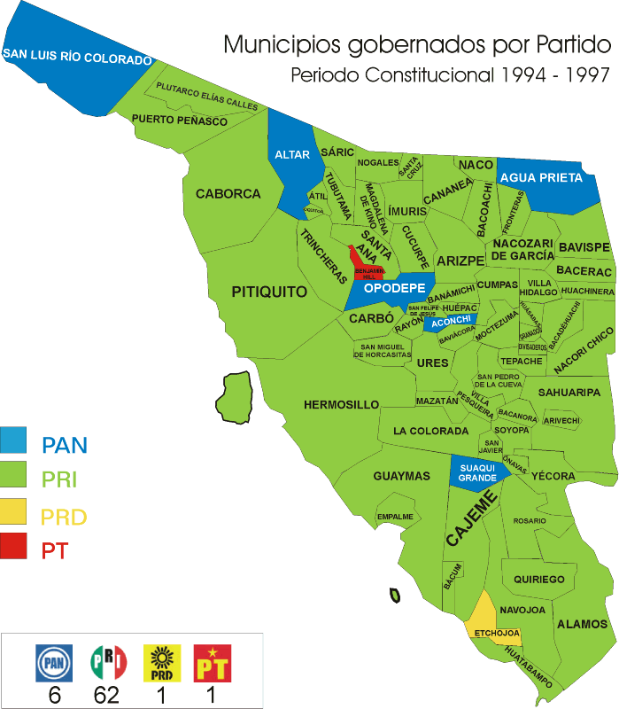
- ^ "Mapa de Municipios gobernados por partido político. Período constitucional 1994–1997" (in Spanish). IEES. Instituto Estatal Electoral y de Participación Ciudadana de Sonora. Retrieved 31 March 2023.
- ^ "Mapa de Municipios gobernados por partido político. Período constitucional 1997–2000" (PDF) (in Spanish). IEES. Instituto Estatal Electoral y de Participación Ciudadana de Sonora. Retrieved 31 March 2023.
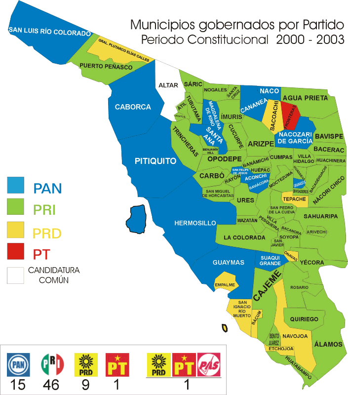
- ^ "Mapa de Municipios gobernados por partido político. Período constitucional 2000–2003" (in Spanish). IEES. Instituto Estatal Electoral y de Participación Ciudadana de Sonora. Retrieved 31 March 2023.
- ^ "Resultados oficiales de la elección de Ayuntamientos. 2003. Puerto Peñasco PRI: 6016 votos. PAN: 5813 votos. PRD: 252 votos. PT: 132 votos" (PDF) (in Spanish). IEES. Instituto Estatal Electoral y de Participación Ciudadana de Sonora. Retrieved 31 March 2023.
- ^ "Mapa de Municipios gobernados por partido político. Período constitucional 2003–2006" (PDF) (in Spanish). IEES. Instituto Estatal Electoral y de Participación Ciudadana de Sonora. Retrieved 31 March 2023.
- ^ "Resultados oficiales de la elección de Ayuntamientos. 2006. Puerto Peñasco. PRI: 9117 votos. PAN: 7107 votos. Coalition for the Good of All (PRD-Convergencia-PT): 528 votos" (PDF) (in Spanish). IEES. Instituto Estatal Electoral y de Participación Ciudadana de Sonora. Retrieved 31 March 2023.
- ^ "Mapa de Municipios gobernados por partido político. Período constitucional 2006–2009" (PDF) (in Spanish). IEES. Instituto Estatal Electoral y de Participación Ciudadana de Sonora. Retrieved 31 March 2023.
- ^ "Resultados oficiales de la elección de Ayuntamientos. 2009. Puerto Peñasco. PAN: 9730 votos. Alianza (PRI-PVEM-Panal): 7567 votos. PRD: 2912 votos. Convergencia: 405 votos. PT: 192 votos" (PDF) (in Spanish). IEES. Instituto Estatal Electoral y de Participación Ciudadana de Sonora. Retrieved 31 March 2023.
- ^ "Proceso Electoral 2011–2012. Elección de Ayuntamiento. 2012. Puerto Peñasco. PRI-PVEM: 11561 votos. PAN-Panal: 9325 votos. PRD: 277 votos. MC: 269. PT: 196 votos" (PDF) (in Spanish). IEES. Instituto Estatal Electoral y de Participación Ciudadana de Sonora. Retrieved 31 March 2023.
- ^ "Mapa de Municipios gobernados por partido político. Período constitucional 2012–2015" (PDF) (in Spanish). IEES. Instituto Estatal Electoral y de Participación Ciudadana de Sonora. Retrieved 31 March 2023.
- ^ "Proceso electoral 2014–2015. Cómputo por municipio. Elección de Ayuntamiento. Puerto Peñasco. PAN: 12853 votos. PRI: 8197 votos. Morena: 367 votos. MC: 358 votos. Partido Encuentro Social (PES): 295 votos. PRD: 160 votos. PT: 120 votos. Partido Humanista (PH): 82 votos. PVEM: 77 votos" (PDF) (in Spanish). IEES. Instituto Estatal Electoral y de Participación Ciudadana de Sonora. Retrieved 31 March 2023.
- ^ "Conformación de planillas de ayuntamiento. Proceso Electoral 2014–2015. Puerto Peñasco" (PDF) (in Spanish). Retrieved 31 March 2023.
- ^ "Mapa de Municipios gobernados por partido político. Período constitucional 2015–2018" (PDF) (in Spanish). Retrieved 31 March 2023.
- ^ "Memoria Estadística 2017–2018. Puerto Peñasco. Coalición "Por Sonora al Frente" (PAN-PRD): 8279 votos. Coalición "Todos por Sonora" (PRI-PVEM-Panal) 5455 votos. Coalición "Juntos Haremos Historia (PT-Morena-PES): 3389 votos" (PDF) (in Spanish). IEES. Instituto Estatal Electoral y de Participación Ciudadana de Sonora. Retrieved 31 March 2023.
- ^ "IEESonora. Resultados 2021. Ayuntamiento Puerto Peñasco. PAN-PRI-PRD: 7737 votos. Morena: 7359 votos. Partido Encuentro Solidario (PES): 4785 votos. Fuerza por México (Force for Mexico) FXM: 637 votos. MC: 294 votos. PVEM: 193 votos" (in Spanish). IEES. Instituto Estatal Electoral y de Participación Ciudadana de Sonora. Retrieved 31 March 2023.
Places adjacent to Puerto Peñasco Municipality | ||||||||||||||||
|---|---|---|---|---|---|---|---|---|---|---|---|---|---|---|---|---|
| ||||||||||||||||
