Pueblo | |
|---|---|
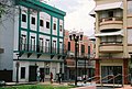
 Plaza La Convalecencia in the main town square. | |
 Location of Pueblo shown in yellow | |
| Coordinates: 18°23′38″N 66°02′52″W / 18.393852°N 66.047738°W [1] | |
| Commonwealth | |
| Municipality | |
| Area | |
| • Total | 0.73 sq mi (1.9 km2) |
| • Land | 0.73 sq mi (1.9 km2) |
| • Water | 0 sq mi (0 km2) |
| Elevation | 207 ft (63 m) |
| Population (2010) | |
| • Total | 8,720 |
| • Density | 11,945.2/sq mi (4,612.1/km2) |
| 2010 census | |
| Time zone | UTC−4 ( AST) |
Río Piedras Pueblo (officially just Pueblo, unofficially downtown Río Piedras), is one of 18 barrios in the municipality of San Juan, Puerto Rico. [3] [4] [5] Rio Piedras Pueblo is what used to be the urban center- barrio (downtown district) of the former municipality of Río Piedras until 1951, when the municipality of Rio Piedras was merged with the municipality of San Juan.
Rio Piedras Pueblo is bounded to the west by Hato Rey Sur and El Cinco, with Universidad barrio to the North, and with Sabana Llana Sur barrio to the south and east. It is made up of 6 subbarrios: Buen Consejo, Capetillo, Monte Rey, Río Piedras Antiguo, Ubarri, and Venezuela. The University of Puerto Rico, Rio Piedras is located nearby.
The central plaza and its church
Before the establishment of the town square, the area was the site of the Hermitage of Our Lady of the Pillar since at least 1647. [6] The central plaza, today known as Plaza de la Convalecencia (La Convalecencia Square), dates to 1823 when the town was granted municipality rights. The old city house and Casa del Rey date to this time. [7] Located across the central plaza is the Church of Our Lady of the Pillar, a Roman Catholic church which used to be the main Catholic parish of the former municipality. [8]
Demographics
| Census | Pop. | Note | %± |
|---|---|---|---|
| 1900 | 2,249 | — | |
| 1950 | 22,532 | — | |
| 1960 | 19,591 | −13.1% | |
| 1970 | 11,296 | −42.3% | |
| 1980 | 8,821 | −21.9% | |
| 1990 | 8,804 | −0.2% | |
| 2000 | 9,391 | 6.7% | |
| 2010 | 8,720 | −7.1% | |
| U.S. Decennial Census 1899 (shown as 1900) [9] 1910-1930 [10] 1930-1950 [11] 1980-2000 [12] 2010 [13] | |||
In 2010, it had a population of 8,720 residing in land area of 0.73 sq. mi. (1.86 km2).
Subbarrios
Pueblo comprises the following six subbarrios (3rd level subdivisions): [14]
Gallery
-
 Cityscape of downtown Rio Piedras (Pueblo).
 -
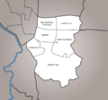 Subbarrios of Río Piedras Pueblo.
 -
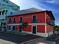
 Old city hall of Río Piedras on Juan Ponce de Leon Ave.
 -
 Church of Our Lady of the Pillar today.
 -
 Historic Casa Georgetti, today site of a museum and cultural center.
 -
![Historic building listed in the National Register of Historic Places since 2016,[7] today referred to as the Puerto Rico Gay Pride Community Building.](https://upload.wikimedia.org/wikipedia/commons/thumb/8/8d/Edificio_Comunidad_de_Orgullo_Gay_de_Puerto_Rico_-_San_Juan_Puerto_Rico.jpg/120px-Edificio_Comunidad_de_Orgullo_Gay_de_Puerto_Rico_-_San_Juan_Puerto_Rico.jpg) Historic building listed in the National Register of Historic Places since 2016, [7] today referred to as the Puerto Rico Gay Pride Community Building.
Historic building listed in the National Register of Historic Places since 2016, [7] today referred to as the Puerto Rico Gay Pride Community Building. -
 Juan Ponce de León Avenue.


.jpg)
![Historic building listed in the National Register of Historic Places since 2016,[7] today referred to as the Puerto Rico Gay Pride Community Building.](/info/en/?search=File:Edificio_Comunidad_de_Orgullo_Gay_de_Puerto_Rico_-_San_Juan_Puerto_Rico.jpg)

See also
References
- ^ a b "US Gazetteer 2019". US Census. US Government.
- ^ U.S. Geological Survey Geographic Names Information System: Pueblo barrio
- ^ Picó, Rafael; Buitrago de Santiago, Zayda; Berrios, Hector H. Nueva geografía de Puerto Rico: física, económica, y social, por Rafael Picó. Con la colaboración de Zayda Buitrago de Santiago y Héctor H. Berrios. San Juan Editorial Universitaria, Universidad de Puerto Rico,1969.
- ^ Gwillim Law (20 May 2015). Administrative Subdivisions of Countries: A Comprehensive World Reference, 1900 through 1998. McFarland. p. 300. ISBN 978-1-4766-0447-3. Retrieved 25 December 2018.
- ^ Puerto Rico: 2010 Population and Housing Unit Counts.pdf (PDF). U.S. Dept. of Commerce, Economics and Statistics Administration, U.S. Census Bureau. 2010.
- ^ "Breve historia del municipio de Río Piedras". EnciclopediaPR. Retrieved 2021-12-12.
- ^ a b "Una breve mirada a la historia de Río Piedras" (in Spanish). Retrieved 2021-12-12.
- ^ Mari Mut, José A. (2013-08-28). Los Pueblos de Puerto Rico y Las Iglesias de Sus Plazas [The Pueblos of Puerto Rico, and the Churches of its Plazas] (PDF) (in Spanish). Archived (PDF) from the original on 2020-12-14. Retrieved 2021-09-16.
- ^ "Report of the Census of Porto Rico 1899". War Department Office Director Census of Porto Rico. Archived from the original on July 16, 2017. Retrieved September 21, 2017.
- ^ "Table 3-Population of Municipalities: 1930 1920 and 1910" (PDF). United States Census Bureau. Archived (PDF) from the original on August 17, 2017. Retrieved September 21, 2017.
- ^ "Table 4-Area and Population of Municipalities Urban and Rural: 1930 to 1950" (PDF). United States Census Bureau. Archived (PDF) from the original on August 30, 2015. Retrieved September 21, 2014.
- ^ "Table 2 Population and Housing Units: 1960 to 2000" (PDF). United States Census Bureau. Archived (PDF) from the original on July 24, 2017. Retrieved September 21, 2017.
- ^ Puerto Rico: 2010 Population and Housing Unit Counts.pdf (PDF). U.S. Dept. of Commerce Economics and Statistics Administration U.S. Census Bureau. 2010. Archived (PDF) from the original on 2017-02-20. Retrieved 2019-08-02.
- ^ "US Census definition of "subbarrio"". factfinder.com. US Census. Archived from the original on 12 February 2019. Retrieved 5 January 2019.
