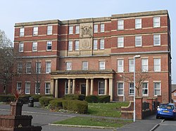
| Preston Royal Infirmary | |
|---|---|
 Main Block | |
Shown in
Preston | |
| Geography | |
| Location | Preston, England, United Kingdom |
| Coordinates | 53°45′58″N 2°41′33″W / 53.76603°N 2.69263°W |
| Organisation | |
| Care system | Public NHS |
| Type | Teaching Hospital |
| History | |
| Opened | 1869 |
| Closed | 1990 |
| Links | |
| Lists | Hospitals in England |

The Preston Royal Infirmary was an acute general hospital in Preston, Lancashire, England. Two remaining buildings are Grade II listed buildings. [1] [2]
History
The hospital had its origins in a House of Recovery constructed between 1829 and 1833. [1] It was extended by James Hibbert between 1866 and 1870 [3] to create the Preston and County of Lancaster Royal Infirmary; this facility became the Preston and County of Lancaster Queen Victoria Royal Infirmary in 1929. [4] A further two storeys were added to the main block in 1936. [1]
It joined the National Health Service as the Preston Royal Infirmary in 1948 and, after services had transferred to the Royal Preston Hospital, it closed in 1990. [4] Two buildings each gained Grade II listed building status on 7 April 1988, and were subsequently converted for use as student halls of residence. [1] [2]
References
- ^ a b c d Historic England. "Deepdale Hall (formerly main block of Preston Royal Infirmary) (1292423)". National Heritage List for England. Retrieved 1 December 2018.
- ^ a b Historic England. "Deepdale Hall (formerly west wing of Preston Royal Infirmary) (1207267)". National Heritage List for England. Retrieved 10 April 2014.
- ^ Hartwell & Pevsner (2009), p. 542
- ^ a b "Preston Infirmary, Preston". National Archives. Retrieved 30 November 2018.
Sources
- Hartwell, Clare; Pevsner, Nikolaus (2009) [1969], Lancashire: North, The Buildings of England, New Haven and London: Yale University Press, ISBN 978-0-300-12667-9

